File:AMH-4591-NA Map of the castle and city of Batavia.jpg
Original file (2,400 × 1,417 pixels, file size: 410 KB, MIME type: image/jpeg)
Captions
Captions
Summary
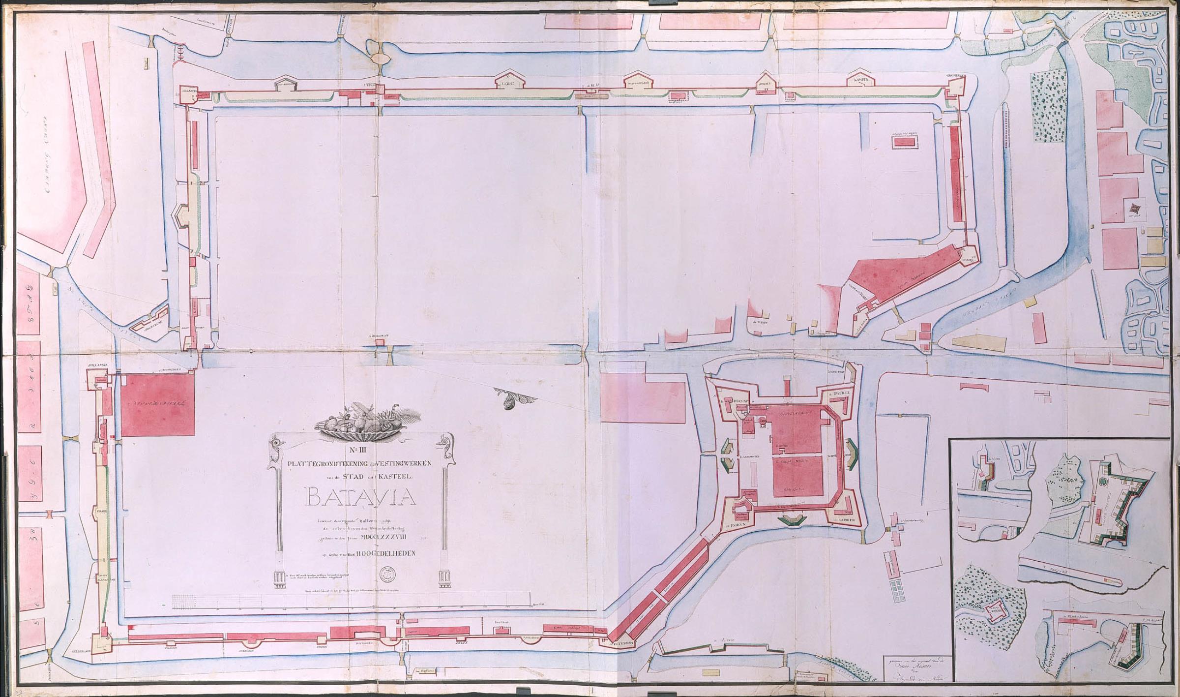
[edit]| Nederlands: Plattegrond van het kasteel en de stad Batavia
English: Map of the castle and city of Batavia Bahasa Indonesia: Peta kastil dan kota Batavia ( |
||||||||||||||||||||||||
|---|---|---|---|---|---|---|---|---|---|---|---|---|---|---|---|---|---|---|---|---|---|---|---|---|
| Author |
Nederlands: Carl Friedrich Reimer (gewerkt naar), Heymerd van Breda (landmeter / kaartenmaker)
English: Carl Friedrich Reimer (copied after), Heymerd van Breda (land surveyor / mapmaker) |
|||||||||||||||||||||||
| Title |
Nederlands: Plattegrond van het kasteel en de stad Batavia
English: Map of the castle and city of Batavia
Bahasa Indonesia: Peta kastil dan kota Batavia |
|||||||||||||||||||||||
| Description |
Nederlands: Titel catalogus Leupe (NA): Platte grondteekening der vestingwerken van de stad en Kasteel Batavia, benevens daar volgende batteryen.
De naam van de kopieerder Heymerd van Breda is bijgeschreven. Stempeltje: Depot des Cart. Pl. et Journ. de la Marine. Notities verso: 619 [met vette cijfers gestempeld op een etiketje] / (1788) [in potlood] / III [in potlood, schuin onder 1788] / No. 196 / no. 7 Reg 2 Fol 4.English: According to the Leupe catalogue (NA), the original title reads: Platte grondteekening der vestingwerken van de stad en Kasteel Batavia, benevens daar volgende batteryen.
The name of the person who made the copy, Heymerd van Breda, has been added. Stamp: Depot des Cart. Pl. et Journ. de la Marine. Notes on reverse: 619 [stamped in bold on a small label] / (1788) [in pencil] / III [in pencil, diagonally beneath 1788] / No. 196 / no. 7 Reg 2 Fol 4.Bahasa Indonesia: Menurut katalog Leupe (NA), judul aslinya berbunyi: Platte grondteekening der vestingwerken van de stad en Kasteel Batavia, benevens daar volgende batteryen.
Nama orang yang membuat salinan, Heymerd van Breda, telah ditambahkan. Stempel: Depot des Cart. Pl. et Journ. de la Marine. Tulisan di belakang: 619 [dicap tebal pada label kecil] / (1788) [menggunakan pensil] / III [dengan pensil, secara diagonal di bawah tulisan 1788] / No. 196 / no. 7 Reg 2 Fol 4. |
|||||||||||||||||||||||
| Date | circa 1788 | |||||||||||||||||||||||
| Medium |
Nederlands: ingekleurde tekening op papier
English: coloured drawing on paper
Bahasa Indonesia: gambar berwarna di atas kertas |
|||||||||||||||||||||||
| Dimensions | height: 173 cm (68.1 in); width: 101.5 cm (39.9 in) | |||||||||||||||||||||||
| Collection |
|
|||||||||||||||||||||||
| Accession number |
NL-HaNA_4.VEL_1191 (old number: VEL1191) |
|||||||||||||||||||||||
| Inscriptions |
Plattegrondtekening der vestingwerken van de stad en 't kasteel Batavia [enz.]
author: door Heymerd van Breda |
|||||||||||||||||||||||
| Notes |
English: Subjects: fortification, banderole / cartouche / ornamentation, chart / map / plan
Nederlands: Onderwerpen: vesting, banderol / cartouche / versiering, plattegrond / kaart
English: Fort: this image is related to a VOC fort called kasteel Batavia |
|||||||||||||||||||||||
| Source/Photographer |
|
|||||||||||||||||||||||
| Permission (Reusing this file) |
|
|||||||||||||||||||||||

| Object location | | View this and other nearby images on: OpenStreetMap |
|---|
File history
Click on a date/time to view the file as it appeared at that time.
| Date/Time | Thumbnail | Dimensions | User | Comment | |
|---|---|---|---|---|---|
| current | 16:42, 10 June 2014 | | 2,400 × 1,417 (410 KB) | HuskyBot (talk | contribs) | == {{int:filedesc}} == {{Artwork |title = {{nl|1=Plattegrond van het kasteel en de stad Batavia}} {{en|1=Map of the castle and city of Batavia}} |description = {{nl|1=Titel catalogus Leupe (NA): ''Platte grondt... |
You cannot overwrite this file.
File usage on Commons
The following page uses this file: