Category:18th-century maps of Batavia
Jump to navigation
Jump to search
Subcategories
This category has the following 2 subcategories, out of 2 total.
Media in category "18th-century maps of Batavia"
The following 63 files are in this category, out of 63 total.
-
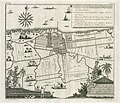
 AMH-5432-NA Map of Batavia and surrounding forts.jpg 2,400 × 1,720; 396 KB
-
 AMH-6707-NA Map showing land ownership and occupation around Batavia.jpg 2,400 × 1,648; 581 KB
-
 AMH-6708-NA Map showing land ownership and occupation around Batavia.jpg 2,400 × 1,449; 451 KB
-
 AMH-6621-NA Map of land parcels around Batavia.jpg 2,400 × 1,466; 503 KB
-
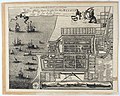
 A mapp of Batavia with all itt's forts. J.N. RMG F0087.tiff 4,805 × 3,749; 51.54 MB
-
 A town plan of the trading port Batavia Wellcome L0038151.jpg 3,888 × 3,156; 3.59 MB
-
 AMH-2527-NA The river of Batavia with plans for new windmills.jpg 2,400 × 1,658; 441 KB
-
 1717 map of Batavia by Herman Moll.jpg 1,214 × 751; 480 KB
-
-
 1723 GMG1097-1102 934 Batavia.jpg 3,886 × 3,259; 3.78 MB
-
 AMH-4587-NA Map for the fortification of the castle at Batavia.jpg 2,400 × 1,722; 514 KB
-
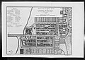
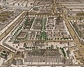
 AMH-6170-NA Map of the city of Batavia.jpg 2,400 × 1,386; 348 KB
-
 AMH-5468-NA Sketch of several farmlands on Batavia.jpg 1,939 × 2,400; 641 KB
-
 AMH-5465-NA Sketch of several farmlands on Batavia.jpg 2,400 × 1,766; 727 KB
-
 AMH-5466-NA Sketch of several farmlands on Batavia.jpg 1,848 × 2,400; 707 KB
-
 AMH-5467-NA Sketch of several farmlands on Batavia.jpg 1,916 × 2,400; 460 KB
-
 AMH-5469-NA Sketch of several farmlands on Batavia.jpg 1,901 × 2,400; 559 KB
-
 AMH-5533-NA Map of the oyster bank at Batavia.jpg 2,400 × 1,250; 367 KB
-

-

-
 AMH-7032-KB Map of Batavia.jpg 2,400 × 2,044; 1.65 MB
-

-
 AMH-7031-KB Map of the new Dutch church on Batavia.jpg 2,039 × 2,400; 1.23 MB
-
 AMH-7042-KB Map of the artisan's quarter in Batavia.jpg 2,400 × 2,042; 1.47 MB
-
 AMH-7046-KB Map of the Maronde trading post near Batavia.jpg 2,400 × 2,070; 1.37 MB
-
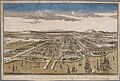
 Batavia, C. de Jonghe (1740).jpg 724 × 580; 235 KB
-
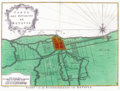
 AMH-5530-NA Map of the north coast of Java, from Geertruys Island to Brenong.jpg 2,400 × 1,268; 536 KB
-
-

-
 AMH-7034-KB Map of the island of Onrust off the coast of Batavia.jpg 2,400 × 2,050; 1.51 MB
-
 AMH-7050-KB Map of the city of Batavia.jpg 2,400 × 2,057; 1.23 MB
-
 Post Meester Cornelis Batavia 1744.jpg 1,000 × 852; 226 KB
-

-
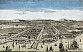
 Dutch Batavia 1754 High Quality.jpg 2,000 × 1,273; 478 KB
-
 Zbatavia.jpg 1,413 × 996; 336 KB
-
 Dutch Batavia circa 1760.jpg 700 × 639; 164 KB
-

-

-
-
 AMH-4577-NA Map of the Zoutelande staging post at Ansjol.jpg 2,400 × 1,116; 219 KB
-
 AMH-4575-NA Map of the waterway at Batavia.jpg 2,400 × 1,248; 412 KB
-
 AMH-4585-NA Map and elevations of the castle at Batavia.jpg 2,400 × 1,649; 515 KB
-
 AMH-4586-NA Map of the city and the castle at Batavia.jpg 1,398 × 2,400; 647 KB
-
 Histoire des deux Indes-Atlas-d31-C13-Batavia et environs.png 2,244 × 1,700; 1.42 MB
-
 AMH-5615-NA Plans for running water supply to the city of Batavia.jpg 2,400 × 1,504; 374 KB
-

-
 Tijgersgracht Batavia.jpg 1,065 × 858; 681 KB
-

-
-
 AMH-2528-NA Western territories of Batavia.jpg 2,400 × 1,714; 438 KB
-
 COLLECTIE TROPENMUSEUM De stad Batavia TMnr 3728-537.jpg 755 × 472; 120 KB
-
 AMH-4591-NA Map of the castle and city of Batavia.jpg 2,400 × 1,417; 410 KB
-
 AMH-4592-NA Map of the castle and city of Batavia.jpg 1,112 × 2,400; 441 KB
-
 AMH-4593-NA Map of the castle and city of Batavia.jpg 1,121 × 2,400; 438 KB
-
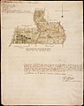
 AMH-4741-NA Map of Batavia and environs.jpg 2,400 × 704; 214 KB
-
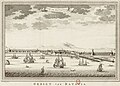
 La rade de Batavia.jpg 445 × 455; 80 KB
-

-
 AMH-4590-NA Map of the castle and city of Batavia.jpg 2,400 × 1,797; 524 KB
-
 104 Vue de Batavia XVIIIème siècle Auteur anonyme.jpg 3,418 × 2,238; 4.49 MB
-
 A map showing the Islands off Batavia (Jakarta) Wellcome L0038170.jpg 3,990 × 3,126; 2.84 MB
-
 AMH-4637-NA Map and elevation of the barracks at Batavia.jpg 2,400 × 1,809; 627 KB
-
 AMH-5581-NA Map of the hospital at Batavia.jpg 2,400 × 1,886; 579 KB
-
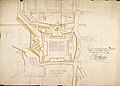
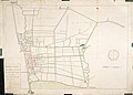
 AMH-6169-NA Map of land divisions around Batavia.jpg 2,400 × 1,707; 526 KB


_Prospect_von_Batavia_(titel_op_object),_RP-P-1911-211.jpg)


.jpg)


.jpg)


.jpg)
.jpg)
.jpg)


_-_A_van_Krevelt,_sculpsit..._Deze_platte_grond_is_vervaardigd_in_1770..._-_btv1b8459452b.jpg)

.jpg)


_Wellcome_L0038170.jpg)


