File:AERIAL VIEW OF THE MALL, LOOKING WEST FROM THE CAPITOL TO THE WASHINGTON MONUMENT FROM ABOVE THIRD STREET, NE. - National Mall and Monument Grounds, Washington, District of Columbia HABS DC,WASH,615-1.tif
Jump to navigation
Jump to search

Size of this JPG preview of this TIF file: 757 × 600 pixels. Other resolutions: 303 × 240 pixels | 606 × 480 pixels | 970 × 768 pixels | 1,280 × 1,014 pixels | 2,560 × 2,028 pixels | 4,759 × 3,770 pixels.
Original file (4,759 × 3,770 pixels, file size: 17.11 MB, MIME type: image/tiff)
Captions
Captions
Add a one-line explanation of what this file represents
Summary[edit]
| AERIAL VIEW OF THE MALL, LOOKING WEST FROM THE CAPITOL TO THE WASHINGTON MONUMENT FROM ABOVE THIRD STREET, NE. - National Mall and Monument Grounds, Washington, District of Columbia, DC | ||||
|---|---|---|---|---|
| Title |
AERIAL VIEW OF THE MALL, LOOKING WEST FROM THE CAPITOL TO THE WASHINGTON MONUMENT FROM ABOVE THIRD STREET, NE. - National Mall and Monument Grounds, Washington, District of Columbia, DC |
|||
| Depicted place | District of Columbia; District of Columbia; Washington | |||
| Date | Documentation compiled after 1933 | |||
| Dimensions | 4 x 5 in. | |||
| Current location |
Library of Congress Prints and Photographs Division Washington, D.C. 20540 USA http://hdl.loc.gov/loc.pnp/pp.print |
|||
| Accession number |
HABS DC,WASH,615-1 |
|||
| Credit line |
|
|||
| Notes |
|
|||
| Source | https://www.loc.gov/pictures/item/dc0787.photos.042661p | |||
| Permission (Reusing this file) |
|
|||

| Object location | | View this and other nearby images on: OpenStreetMap |
|---|
File history
Click on a date/time to view the file as it appeared at that time.
| Date/Time | Thumbnail | Dimensions | User | Comment | |
|---|---|---|---|---|---|
| current | 18:39, 10 July 2014 | 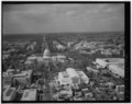 | 4,759 × 3,770 (17.11 MB) | Fæ (talk | contribs) | GWToolset: Creating mediafile for Fæ. HABS 08 July 2014 (701:800) |
You cannot overwrite this file.
File usage on Commons
The following page uses this file: