File:360° Schadonapaß.jpg
Jump to navigation
Jump to search

Size of this preview: 798 × 114 pixels. Other resolutions: 320 × 46 pixels | 640 × 92 pixels | 1,024 × 146 pixels | 1,280 × 183 pixels | 11,061 × 1,582 pixels.
Original file (11,061 × 1,582 pixels, file size: 5.06 MB, MIME type: image/jpeg)
Captions
Captions
Add a one-line explanation of what this file represents
| Description |
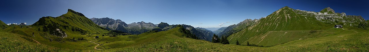
Deutsch: 11³° Uhr Mittag. 360°-Panorama auf dem Schadonapass an der Biberacher Hütte, die am Europäischen Fernwanderweg Nr.4 PYRENÄEN-NORDALPEN-PELOPONNES Alpine Variante, sowie dem Weitwanderweg 601 liegt. Die Berge von links nach rechts: das dunkle Bergmassiv ist der Große Widderstein (2533 m), der grüne Berg ist das Rothorn (2239 m). Am Fuß die Schadonaalpe und dahinter die Litehütte (Jagdhütte). Es folgt die Braunarlspitze (2649 m), Orgelspitze (2592 m), Löffelspitze (2563 m), Hochlichtspitze (2600 m), der östliche und westliche Johanneskopf, der Bratschenkopf (2520 m), der Feuerstein (2271 m) und die Disnerhöhe mit 2105 m. Der Gebirgseinschnitt hinter der Jägerhütte ist das Große Walsertal. Von dort führt der gerade Weg unter der Glattjöchlspitze (2106 m) von der Alpe Iscarnei hinauf zur Hochkünzelspitze (2397 m). Der Giglturm (2112 m) und die Wasserkluppe (2081 m) in Schröcken beenden das Panorama im Lechquellengebirge.
English: 360 ° panorama on the Schadonapass at the Biberacher hut on the European walking route E4 alpine variant, and on the trail 601. From left to right: the dark mountains is the Great Widderstein (2533 m), the green mountain is the Rothorn (2239 m). Following is the Braunarlspitze (2649 m), Orgelspitze (2592 m), Löffelspitze (2563 m), Hochlichtspitze (2600 m), the Eastern + Western Johanneskopf, Bratschenkopf (2520 m), Feuerstein (2271 m) and Disnerhöhe (2105 m). The gap behind the Hochsitz mountain is the Großes Walsertal. From there the road just below the Glattjöchlspitze (2106m) leads from the Iscarnei alp to the Hochkünzelspitze at 2397 m. The Giglturm (2112 m) and the Wasserkluppe (2081 m) in Schröcken end the panorama of Vorarlberg's Lechquellengebirge. Imahe taken at half past eleven.
Français : Image panoramique à 360° montrant la vue sur le Schadonapass depuis le refuge de Biberach, sur le Sentier européen E4 (variante alpine). De la gauche vers la droite, on distingue: le grand Widderstein (noir, 2533 m), et le Rothorn (vert, 2239 m). Viennent ensuite le Braunarlspitze (2649m), l'Orgelspitze (2592 m), le Löffelspitze (2563 m), le Hochlichtspitze (2600 m), les Johanneskopf oriental et occidental, le Bratschenkopf (2520 m), le Feuerstein (2271 m) et le Disnerhöhe (2105 m). l'encoche derrière l'Hochsitz s'appelle le Großes Walsertal. De là, la route sous le Glattjöchlspitze (2106 m) mène de l'Iscarnei alp au Hochkünzelspitze à 2397 m. Le Giglturm (2112 m) et le Wasserkluppe (2081 m, dans le Schröcken) ferment le panorama sur le Massif de Lechquellen dans le Vorarlberg, en Autriche.
|
||
| Date | |||
| Source | Own work | ||
| Author | böhringer friedrich | ||
| Permission (Reusing this file) |
I, the copyright holder of this work, hereby publish it under the following license: This file is licensed under the Creative Commons Attribution-Share Alike 2.5 Generic license.
|

|

This Photo was taken by Böhringer Friedrich.
|
Feel free to use my photos, but please mention me as the author and if you want send me a message. or (rufre@lenz-nenning.at) |
| 360° | View in 360° panoramic viewer
|
|---|
| Camera location | | View this and other nearby images on: OpenStreetMap |
|---|
This image has been assessed using the Quality image guidelines and is considered a Quality image.
|
| Annotations | This image is annotated: View the annotations at Commons |
File history
Click on a date/time to view the file as it appeared at that time.
| Date/Time | Thumbnail | Dimensions | User | Comment | |
|---|---|---|---|---|---|
| current | 19:42, 9 August 2009 | 11,061 × 1,582 (5.06 MB) | Böhringer (talk | contribs) | {{Information |Description= {{de| 11³° Uhr Mittag. 360° Panorama auf dem Schadonapass an der Biberacher Hütte, die am [[:de:Europäischer Fernwanderweg E4|Europäischen Fernwanderweg Nr.4 PYRENÄEN-NORDALPEN-PELOPONNES Alpine |
You cannot overwrite this file.
File usage on Commons
The following 24 pages use this file:
- Exzellente Bilder aus Vorarlberg
- Hiking
- Vorarlberg
- User:Böhringer
- User:Böhringer/Archive 2
- User:The High Fin Sperm Whale/Favourites
- Commons:Featured picture candidates/File:360° Schadonapaß.jpg
- Commons:Featured picture candidates/Log/August 2009
- Commons:Featured pictures/Places/Natural/Austria
- Commons:Featured pictures/Places/Panoramas
- Commons:Featured pictures/chronological/2009-B
- Commons:Picture of the Year/2009/Galleries/2009-B
- Commons:Picture of the Year/2009/Galleries/All
- Commons:Picture of the Year/2009/Galleries/Index/11
- Commons:Picture of the Year/2009/Galleries/Index/Panoramas
- Commons:Picture of the Year/2009/Galleries/Panoramas
- Commons:Picture of the Year/2009/Galleries/Panoramas/1
- Commons:Picture of the Year/2009/Galleries/Table/200908
- Commons:Picture of the Year/2009/R1/File:360° Schadonapaß.jpg
- Commons:Picture of the Year/2009/Results/R1/ALL/Table
- Commons:Picture of the Year/2009/Results/R1/Panoramas
- Commons:Picture of the Year/2009/Results/R1/Panoramas/Table
- Commons:Quality images/Subject/Places/Natural structures/Panorama/Archive 2008 to 2015
- Commons:Quality images candidates/Archives August 2009
File usage on other wikis
The following other wikis use this file:
- Usage on de.wikipedia.org
- Usage on fr.wikipedia.org
- Usage on ku.wikipedia.org
- Usage on pl.wikipedia.org
- Usage on sv.wikipedia.org
- Usage on vi.wikipedia.org