File:2022 East Timor, administrative divisions - de - colour.tif
Jump to navigation
Jump to search

Size of this JPG preview of this TIF file: 800 × 461 pixels. Other resolutions: 320 × 185 pixels | 640 × 369 pixels | 1,024 × 591 pixels | 1,280 × 738 pixels | 3,344 × 1,929 pixels.
Original file (3,344 × 1,929 pixels, file size: 18.46 MB, MIME type: image/tiff)
Captions
Captions
Add a one-line explanation of what this file represents
Summary[edit]
| Description |
Deutsch: Lagekarte der Gemeinden Osttimors seit 2022 English: Locator map of municipalities of East Timor since 2022 |
| Date | |
| Source | Own work |
| Author | J. Patrick Fischer |

|
This map image could be re-created using vector graphics as an SVG file. This has several advantages; see Commons:Media for cleanup for more information. If an SVG form of this image is available, please upload it and afterwards replace this template with
{{vector version available|new image name}}.
It is recommended to name the SVG file “2022 East Timor, administrative divisions - de - colour.svg”—then the template Vector version available (or Vva) does not need the new image name parameter. |
Licensing[edit]
I, the copyright holder of this work, hereby publish it under the following licenses:

|
Permission is granted to copy, distribute and/or modify this document under the terms of the GNU Free Documentation License, Version 1.2 or any later version published by the Free Software Foundation; with no Invariant Sections, no Front-Cover Texts, and no Back-Cover Texts. A copy of the license is included in the section entitled GNU Free Documentation License. |
This file is licensed under the Creative Commons Attribution-Share Alike 3.0 Unported license.
- You are free:
- to share – to copy, distribute and transmit the work
- to remix – to adapt the work
- Under the following conditions:
- attribution – You must give appropriate credit, provide a link to the license, and indicate if changes were made. You may do so in any reasonable manner, but not in any way that suggests the licensor endorses you or your use.
- share alike – If you remix, transform, or build upon the material, you must distribute your contributions under the same or compatible license as the original.
You may select the license of your choice.
File history
Click on a date/time to view the file as it appeared at that time.
| Date/Time | Thumbnail | Dimensions | User | Comment | |
|---|---|---|---|---|---|
| current | 19:14, 4 April 2022 | 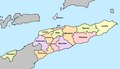 | 3,344 × 1,929 (18.46 MB) | J. Patrick Fischer (talk | contribs) | {{Information |Description={{de|Lagekarte der Gemeinden Osttimors seit 2022}} {{en|Locator map of municipalities of East Timor since 2022}} |Source= {{own}} |Date=2022-04-04 |Author=J. Patrick Fischer |Permission= |other_versions= }} == {{int:license-header}} == {{Self|GFDL|Cc-by-sa-3.0}} Category:Maps of municipalities of East Timor Category:Maps of Subdivisions of East Timor Category:Images by J. Patrick Fischer |
You cannot overwrite this file.
File usage on Commons
The following page uses this file:
File usage on other wikis
The following other wikis use this file:
- Usage on ar.wikipedia.org
- Usage on cs.wikipedia.org
- Usage on de.wikipedia.org
- Usage on es.wikipedia.org
- Usage on frr.wikipedia.org
- Usage on hu.wiktionary.org
- Usage on id.wikipedia.org
- Usage on incubator.wikimedia.org
- Usage on is.wikipedia.org
- Usage on ko.wikipedia.org
- Usage on mnw.wikipedia.org
- Usage on ms.wikipedia.org
- Larisula
- Lavateri
- Osso-Huna
- Samalari (Baguia)
- Gariuai
- Seiçal
- Samalari
- Caibada Uaimua
- Afaçá
- Buruma (Baucau)
- Buibau
- Bahú
- Uacala
- Bualale
- Guruça
- Uailili
- Atelari
- Libagua
- Nunira
- Saelari
- Sagadate
- Samalari (Laga)
- Soba (Laga)
- Tequinaumata
- Abafala
- Abo (Quelicai)
- Lacoliu
- Laisorulai de baixo
- Laisorulai de cima
- Lelalai
- Letemumo
- Macalaco
- Maluro
View more global usage of this file.