File:2006 Illinois gubernatorial election results map by county.svg
Jump to navigation
Jump to search

Size of this PNG preview of this SVG file: 600 × 600 pixels. Other resolutions: 240 × 240 pixels | 480 × 480 pixels | 768 × 768 pixels | 1,024 × 1,024 pixels | 2,048 × 2,048 pixels | 810 × 810 pixels.
Original file (SVG file, nominally 810 × 810 pixels, file size: 43 KB)
Captions
Captions
Add a one-line explanation of what this file represents
Summary[edit]
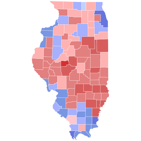
| Description |
English: Republican >= 30%
Republican >= 40%
Republican >= 50%
Republican >= 60%
Republican >= 70%
Democrat >= 30%
Democrat >= 40%
Democrat >= 50%
Democrat >= 60% |
| Date | |
| Source | File:Illinois Presidential Election Results 2016.svg |
| Author | US gov - derivative work: base map by Ali Zifan, coloring by Vartemp |
Licensing[edit]
This file is licensed under the Creative Commons Attribution-Share Alike 4.0 International license.
- You are free:
- to share – to copy, distribute and transmit the work
- to remix – to adapt the work
- Under the following conditions:
- attribution – You must give appropriate credit, provide a link to the license, and indicate if changes were made. You may do so in any reasonable manner, but not in any way that suggests the licensor endorses you or your use.
- share alike – If you remix, transform, or build upon the material, you must distribute your contributions under the same or compatible license as the original.
File history
Click on a date/time to view the file as it appeared at that time.
| Date/Time | Thumbnail | Dimensions | User | Comment | |
|---|---|---|---|---|---|
| current | 19:10, 24 December 2023 | | 810 × 810 (43 KB) | Putitonamap98 (talk | contribs) | shapes and corrected results |
| 04:04, 26 December 2022 |  | 744 × 744 (284 KB) | Gordfather69 (talk | contribs) | Shapes | |
| 21:55, 5 September 2022 |  | 187 × 337 (64 KB) | Elli (talk | contribs) | Reverted to version as of 05:14, 14 December 2021 (UTC) undo reverts to worse maps | |
| 23:37, 4 September 2022 |  | 187 × 337 (36 KB) | TylerKutschbach (talk | contribs) | Reverted to version as of 01:17, 23 July 2021 (UTC) Back to standard map | |
| 05:14, 14 December 2021 |  | 187 × 337 (64 KB) | Kingofthedead (talk | contribs) | Reverted to version as of 19:21, 22 January 2021 (UTC) | |
| 01:17, 23 July 2021 |  | 187 × 337 (36 KB) | TylerKutschbach (talk | contribs) | Reverted to version as of 00:57, 5 April 2020 (UTC) | |
| 19:21, 22 January 2021 |  | 187 × 337 (64 KB) | Kingofthedead (talk | contribs) | Reverted to version as of 19:13, 28 January 2020 (UTC) | |
| 00:57, 5 April 2020 |  | 187 × 337 (36 KB) | Melvingatez34 (talk | contribs) | standard shapes | |
| 19:13, 28 January 2020 |  | 187 × 337 (64 KB) | SpeedMcCool (talk | contribs) | The colors in the original map were incorrect. | |
| 05:18, 15 December 2019 |  | 187 × 337 (38 KB) | Melvingatez34 (talk | contribs) | Reverted to version as of 14:27, 8 March 2018 (UTC) |
You cannot overwrite this file.
File usage on Commons
The following 12 pages use this file:
- User:Magog the Ogre/Political maps/2018 December 21-31
- User:Magog the Ogre/Political maps/2018 March 1-10
- User:Magog the Ogre/Political maps/2019 December 11-20
- User:Magog the Ogre/Political maps/2020 April 1-10
- User:Magog the Ogre/Political maps/2020 January 21-31
- User:Magog the Ogre/Political maps/2021 December 11-20
- User:Magog the Ogre/Political maps/2021 January 21-31
- User:Magog the Ogre/Political maps/2021 July 21-31
- User:Magog the Ogre/Political maps/2022 December 21-31
- User:Magog the Ogre/Political maps/2022 September 1-10
- User:Magog the Ogre/Political maps/2023 December 21-31
- File:Illinois Governor Election Results by County, 2006.svg (file redirect)
File usage on other wikis
The following other wikis use this file: