File:2004 Doğubayazıt earthquake.jpg
Jump to navigation
Jump to search

Size of this preview: 513 × 599 pixels. Other resolutions: 205 × 240 pixels | 612 × 715 pixels.
Original file (612 × 715 pixels, file size: 199 KB, MIME type: image/jpeg)
Captions
Captions
Add a one-line explanation of what this file represents
| Description |
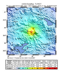
English: Intensity map of 2004 Doğubayazıt earthquake. |
|||
| Date | ||||
| Source | https://earthquake.usgs.gov/earthquakes/shakemap/atlas/shake/200407012230/download/intensity.jpg | |||
| Author | USGS | |||
| Permission (Reusing this file) |
|
File history
Click on a date/time to view the file as it appeared at that time.
| Date/Time | Thumbnail | Dimensions | User | Comment | |
|---|---|---|---|---|---|
| current | 10:22, 20 April 2011 | | 612 × 715 (199 KB) | Seksen iki yüz kırk beş (talk | contribs) | {{Information |Description ={{en|1=Intensity map of 2004 Doğubayazıt earthquake.}} |Source =http://earthquake.usgs.gov/earthquakes/shakemap/atlas/shake/200407012230/download/intensity.jpg |Author =USGS |Date =July 2, 2004 |P |
You cannot overwrite this file.
File usage on Commons
There are no pages that use this file.
File usage on other wikis
The following other wikis use this file:
- Usage on fr.wikipedia.org
- Usage on ku.wikipedia.org
- Usage on tr.wikipedia.org
- 2004 Doğubayazıt depremi
- Vikipedi:Günün maddeleri/Temmuz 2020
- Şablon:GM/2020-07-02
- Vikipedi:Günün kaliteli maddesi/Ağustos 2021
- Şablon:GKM/2021-08-09
- Kullanıcı:LostMyMind/GKM logları/2023
- Vikipedi:Günün kaliteli maddesi/Haziran 2022
- Şablon:GKM/2022-06-27
- Kullanıcı:LostMyMind/GKM logları/2021
- Kullanıcı:LostMyMind/GKM logları/2022
- Vikipedi:Günün kaliteli maddesi/Mayıs 2023
- Şablon:GKM/2023-05-10
- Kullanıcı:LostMyMind/GKM logları
- Vikipedi:Günün kaliteli maddesi/Mart 2024
- Şablon:GKM/2024-03-16