File:1867 Beers North Castle map Armonk closeup.jpg
Jump to navigation
Jump to search
No higher resolution available.
1867_Beers_North_Castle_map_Armonk_closeup.jpg (516 × 349 pixels, file size: 205 KB, MIME type: image/jpeg)
Captions
Captions
Add a one-line explanation of what this file represents
| Description |
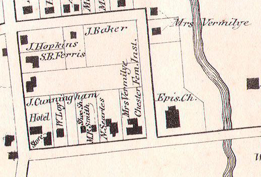
English: Closeup of an 1867 Beers map of North Castle showing the hamlet of Armonk and the future Bedford Road Historic District as they were at the time. |
|||
| Date | 1867; excerpt made 2014-05-14 | |||
| Source |
|
|||
| Author | http://www.geographicus.com/mm5/cartographers/beers.txt, Excerpt cropped by Daniel Case shortly before upload | |||
| Permission (Reusing this file) |
|
|||
| Other versions | Original file here |

File history
Click on a date/time to view the file as it appeared at that time.
| Date/Time | Thumbnail | Dimensions | User | Comment | |
|---|---|---|---|---|---|
| current | 00:39, 15 May 2014 | | 516 × 349 (205 KB) | Daniel Case (talk | contribs) | {{Information |Description ={{en|1=Closeup of an 1867 Beers map of North Castle showing the hamlet of Armonk and the future Bedford Road [[w:Historic districts... |
You cannot overwrite this file.
File usage on Commons
There are no pages that use this file.
File usage on other wikis
The following other wikis use this file:
- Usage on en.wikipedia.org