File:1865 Bellin Sea Chart of Western Africa ( Senegal, Gambia, Guinea, etc.) - Geographicus - WestAfrica2-bellin-1765.jpg
Jump to navigation
Jump to search

Size of this preview: 380 × 599 pixels. Other resolutions: 152 × 240 pixels | 304 × 480 pixels | 487 × 768 pixels | 649 × 1,024 pixels | 1,299 × 2,048 pixels | 4,000 × 6,306 pixels.
Original file (4,000 × 6,306 pixels, file size: 4.54 MB, MIME type: image/jpeg)
Captions
Captions
Add a one-line explanation of what this file represents
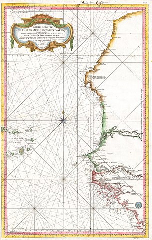
| Jacques-Nicolas Bellin: Carte Reduite Des Costes Occidentales D’Afrique.
( |
||||||||||||||||||||
|---|---|---|---|---|---|---|---|---|---|---|---|---|---|---|---|---|---|---|---|---|
| Artist |
|
|||||||||||||||||||
| Title |
Carte Reduite Des Costes Occidentales D’Afrique. |
|||||||||||||||||||
| Description |
English: This large nautical chart of Western African was produced by the French Cartographer Jacques-Nicolas Bellin. Depicts Western Africa from The Canary Islands South through Western Sahara, Senegal, Guinea-Bissau, the Gambia, Guinea, and Sierra Leone. This is primarily a costal chart with depth soundings and navigational marks, but does show the river courses and considerable interior details in the Cape Verde Islands. The remainder of the interior remains largely unmapped. There is a large decorative title cartouche in the upper left as well as a Depot del la Marine stamp in the lower right. All in all, an extraordinary sea chart of Africa’s northwest coast. |
|||||||||||||||||||
| Date | 1765 | |||||||||||||||||||
| Dimensions | height: 22 in (55.8 cm); width: 35 in (88.9 cm) | |||||||||||||||||||
| Accession number |
Geographicus link: WestAfrica2-bellin-1765 |
|||||||||||||||||||
| Source/Photographer |
|
|||||||||||||||||||
| Permission (Reusing this file) |
|
|||||||||||||||||||
File history
Click on a date/time to view the file as it appeared at that time.
| Date/Time | Thumbnail | Dimensions | User | Comment | |
|---|---|---|---|---|---|
| current | 10:55, 24 March 2011 | | 4,000 × 6,306 (4.54 MB) | BotMultichillT (talk | contribs) | {{subst:User:Multichill/Geographicus |link=http://www.geographicus.com/P/AntiqueMap/WestAfrica2-bellin-1765 |product_name=1865 Bellin Sea Chart of Western Africa ( Senegal, Gambia, Guinea, etc.) |map_title=Carte Reduite Des Costes Occidentales D’Afrique |
You cannot overwrite this file.
File usage on Commons
The following page uses this file:
_-_Geographicus_-_WestAfrica2-bellin-1765.jpg)
File usage on other wikis
The following other wikis use this file:
- Usage on de.wikipedia.org
- Usage on en.wikipedia.org
- Usage on es.wikipedia.org
- Usage on fa.wikipedia.org
- Usage on fi.wikipedia.org
- Usage on it.wikipedia.org
- Usage on uk.wikipedia.org
_-_Geographicus_-_WestAfrica2-bellin-1765.jpg&oldid=752602188)