File:1855 Colton Map of the World on Mercator Projection - Geographicus - WorldMercator-colton-1855.jpg
Jump to navigation
Jump to search

Size of this preview: 800 × 533 pixels. Other resolutions: 320 × 213 pixels | 640 × 426 pixels | 1,024 × 682 pixels | 1,280 × 853 pixels | 2,560 × 1,705 pixels | 5,000 × 3,331 pixels.
Original file (5,000 × 3,331 pixels, file size: 5.34 MB, MIME type: image/jpeg)
Captions
Captions
Add a one-line explanation of what this file represents
| J. H. Colton: Colton's Map of The World on Mercator's Projection.
( |
|||||||||||||||||||||
|---|---|---|---|---|---|---|---|---|---|---|---|---|---|---|---|---|---|---|---|---|---|
| Artist |
|
||||||||||||||||||||
| Title |
Colton's Map of The World on Mercator's Projection. |
||||||||||||||||||||
| Description |
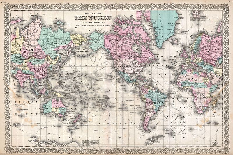
English: A beautiful 1855 first edition example of Colton's map of the World on a Mercator Projection. Centered on the continent of America, this map of the world is hand colored in pink, green, yellow and blue pastels. This map is a reduction and re-engraving of Colton's important 1848 wall map of the world. Colton identifies the routes taken by various important explorers including Cook, Vancouver, Vincennes, and Perouse. A notes at the bottom of the map describes the 1841 discoveries of Mt. Terror and Mt. Erebus in Antarctica by Captain Ross. Much of central Africa is marked Unexplored Regions. Surrounded by Colton's typical spiral motif border. Dated and copyrighted to J. H. Colton, 1855. Published from Colton's 172 William Street Office in New York City. Issued as page nos. 8 and 9 in volume 1 of the first edition of George Washington Colton's 1855 Atlas of the World . |
||||||||||||||||||||
| Date | 1855 (dated) | ||||||||||||||||||||
| Dimensions | height: 16 in (40.6 cm); width: 27 in (68.5 cm) | ||||||||||||||||||||
| Accession number |
Geographicus link: WorldMercator-colton-1855 |
||||||||||||||||||||
| Source/Photographer |
Colton, G. W., Colton's Atlas of the World Illustrating Physical and Political Geography, Vol 2, New York, 1855 (First Edition).
|
||||||||||||||||||||
| Permission (Reusing this file) |
|
||||||||||||||||||||

File history
Click on a date/time to view the file as it appeared at that time.
| Date/Time | Thumbnail | Dimensions | User | Comment | |
|---|---|---|---|---|---|
| current | 15:51, 23 March 2011 | | 5,000 × 3,331 (5.34 MB) | BotMultichillT (talk | contribs) | {{subst:User:Multichill/Geographicus |link=http://www.geographicus.com/P/AntiqueMap/WorldMercator-colton-1855 |product_name=1855 Colton Map of the World on Mercator Projection |map_title=Colton's Map of The World on Mercator's Projection. |description=A b |
You cannot overwrite this file.
File usage on Commons
The following page uses this file:
File usage on other wikis
The following other wikis use this file:
- Usage on incubator.wikimedia.org