File:1818 Pinkerton Map of North America and South America - Geographicus - AmericaNS-pinkerton-1818.jpg
Jump to navigation
Jump to search

Size of this preview: 442 × 599 pixels. Other resolutions: 177 × 240 pixels | 354 × 480 pixels | 567 × 768 pixels | 756 × 1,024 pixels | 1,512 × 2,048 pixels | 3,691 × 5,000 pixels.
Original file (3,691 × 5,000 pixels, file size: 3.64 MB, MIME type: image/jpeg)
Captions
Captions
Add a one-line explanation of what this file represents
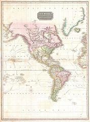
| John Pinkerton: The World on Mercator's Projection Western Part.
( |
|||||||||||||||||||||
|---|---|---|---|---|---|---|---|---|---|---|---|---|---|---|---|---|---|---|---|---|---|
| Artist |
|
||||||||||||||||||||
| Title |
The World on Mercator's Projection Western Part. |
||||||||||||||||||||
| Description |
English: A rare and important 1818 map of the Western Hemisphere by John Pinkerton. Depicts North America, Central America and South America as well as parts of Polynesia, Siberia, Greenland, Iceland, Europe and Africa. The routes of various important explores are noted, including Cook, Vancouver, Perouse, and the return route of the Resolution. In North America, thanks primarily to the work of Cook in the Pacific Northwest the coasts are rendered with considerable accuracy. The interior of North America, particularly the American West, is still rather vague, though much of the cartography is clearly derived from Humboldt's explorations. Notes the apocryphal River Buenaventura as well as a conjectural placement of the western extreme of the Missouri River. The United States, still quite small, does not yet include Florida, Louisiana, California or Texas. South America exhibits its typical clear outline and speculative interior. Pinkerton resurrects the idea of Lake Parima in Guyana - supposed site of El Dorado - which had all but disappeared from most other early 19th century. He has however, dropped the Apocryphal Laguna de Xarayes, commonly located at the northern extremis of the Paraguay or Parma River. However, he does note several supposed gold mines deep in the Amazon, which may or may not reflect indigenous legends of El Dorado. Drawn by L. Herbert and engraved by Samuel Neele under the direction of John Pinkerton. The map comes from the scarce American edition of Pinkerton’s Modern Atlas, published by Thomas Dobson & Co. of Philadelphia in 1818. |
||||||||||||||||||||
| Date | 1818 (undated) | ||||||||||||||||||||
| Dimensions | height: 28 in (71.1 cm); width: 21 in (53.3 cm) | ||||||||||||||||||||
| Accession number |
Geographicus link: AmericaNS-pinkerton-1818 |
||||||||||||||||||||
| Source/Photographer |
Pinkerton, J., A Modern Atlas, from the Lates and Best Authorities, Exhibiting the Various Divisions of the World with its chief Empires, Kingdoms, and States; in Sixty Maps, carefully reduced from the Larges and Most Authentic Sources. 1818, Philadelphia, Thomas Dobson Edition.
|
||||||||||||||||||||
| Permission (Reusing this file) |
|
||||||||||||||||||||

File history
Click on a date/time to view the file as it appeared at that time.
| Date/Time | Thumbnail | Dimensions | User | Comment | |
|---|---|---|---|---|---|
| current | 05:36, 23 March 2011 | | 3,691 × 5,000 (3.64 MB) | BotMultichillT (talk | contribs) | {{subst:User:Multichill/Geographicus |link=http://www.geographicus.com/P/AntiqueMap/AmericaNS-pinkerton-1818 |product_name=1818 Pinkerton Map of North America and South America |map_title=The World on Mercator's Projection Western Part. |description=A rar |
You cannot overwrite this file.
File usage on Commons
The following page uses this file:
File usage on other wikis
The following other wikis use this file:
- Usage on el.wikipedia.org