File:1732 Herman Moll Map of the West Indies, Florida, Mexico, and the Caribbean - Geographicus - WestIndies-moll-1720.jpg
Jump to navigation
Jump to search

Size of this preview: 800 × 468 pixels. Other resolutions: 320 × 187 pixels | 640 × 374 pixels | 1,024 × 599 pixels | 1,280 × 749 pixels | 2,560 × 1,497 pixels | 6,000 × 3,509 pixels.
Original file (6,000 × 3,509 pixels, file size: 6.54 MB, MIME type: image/jpeg)
Captions
Captions
Add a one-line explanation of what this file represents
| Artist | ||||||
| Title |
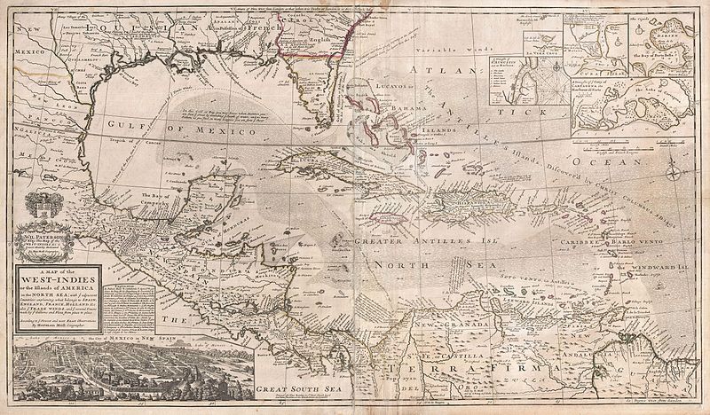
A Map of the West-Indies or the Islands of America in the North Sea; with ye adjacent Countries; explaining what belongs to Spain, England, France, Holland &c. also ye Trade Winds, and ye several Tracts made by ye Galeons and Flota from place to place. According to ye newest and most exact observations, by Herman Moll, Geographer. |
|||||
| Description |
English: One of the most remarkable and intriguing maps of the West Indies to appear in the 18th century. This is Herman Moll's superb circa 1720 mapping of the West Indies, Caribbean, Gulf of Mexico, Mexico, and the Spanish Main. Monumental in proportion, rich in descriptive text, and exhaustive it its attention to detail, this map is best understood as a guide to English piracy and privateering in the West Indies. Moll, most likely through his acquaintance with pirates William Dampier and Woodes Rogers, offers a wealth of information on the traffic of silver bearing Spanish treasure fleets en route from the Mexican port of Veracruz, through the islands, to Spanish ports in Europe. Following the dotted line, Moll identifies the Spanish treasure fleet's entrada into the Caribbean via the passage between Granada and Trinidad. The fleet then sailed westwards, skirting the Spanish Main until they reached Cartagena, where they rested and reprovisioned before heading northwards, rounding western Cuba and stopping in Havana. Using the strong Gulf Stream current - shown here - ships would sail northwards from Havana while being steadily forced to the southeast thus alighting at the deep water port of Veracruz. On the return, laden with silver from the mines of San Luis Potosi, the Spanish fleet took advantage of eastward blowing trade winds, which helped to overcome the strong current on the sail to Havana. From Havana they would travel northwards via the narrow passage between Florida and the Bahamas before cutting eastward and out to sea at St. Augustine. It was here, in this crucial passage between the English dominated Bahamas and Spanish Florida, that the most nefarious pirates lay in wait for their prey. In addition to descriptions of the sailing routes and currents, Moll provides insets of five important Spanish ports, including St. Augustine, Veracruz, Havana, Porto Bella, and Cartagena. As privateer fleets grew in strength and number in the early 18th century full scale assaults on major ports became increasingly common. Moll's choice of these key treasure ports leaves little doubt regarding his intentions and sources. Moll further fills this marvelous map with numerous notations that, while bearing no direct impact on piracy in the region, do offer considerable insight into his political persuasions. He identifies, for example the river route through Tabasco and Chiapas, via which supplies and cannons were transported to the important Pacific port of Acapulco. He also notes the Spanish fort of Pensacola where all their Indians have Deserted and gone to ye French at Mobile. Just to the east of this, in northern Florida, he identifies the land of the Apalache, once a powerful Indian empire which by Moll's time had all but vanished. This area was attacked and, according to Moll, brought over to English rule by the governor of South Carolina, James Moore, in 1704. In a few areas he also comments on some of the produce and mineral richness of the land, identifying the Silver Mines of Coahuila, the American Indian horseman of the Great Plains, Cacao Plantations in Costa Rica, sources of indigo, cochineal, and silvester in the mountains of Guatemala, and the great number of Breeves in Cuba and Texas. Breeves, curiously, were a kind of wild Spanish bovine that later evolved into the Texas Longhorn. Cartographically this map does offer a few interesting innovations. These include Moll's careful and accurate depiction of the Gulf Stream current as well as his orientation of Florida's St. John's River (St. Whan's R). This is the first map since the 16th century Le Moyne map to correctly plot the St. John's river running south from its entrada north of St. Augustine. Earlier maps plotted the river running northwest into the great lake of Apalache - an error dating to Mercator's faulty 1608 mapping of the region. |
|||||
| Date | circa 1720(undated) | |||||
| Dimensions | height: 24 in (60.9 cm); width: 40 in (101.6 cm) | |||||
| Accession number |
Geographicus link: WestIndies-moll-1720 |
|||||
| Source/Photographer |
Moll, H., A New and Complete Atlas, c. 1720.
|
|||||
| Permission (Reusing this file) |
|
|||||
File history
Click on a date/time to view the file as it appeared at that time.
| Date/Time | Thumbnail | Dimensions | User | Comment | |
|---|---|---|---|---|---|
| current | 00:33, 24 March 2011 | | 6,000 × 3,509 (6.54 MB) | BotMultichillT (talk | contribs) | {{subst:User:Multichill/Geographicus |link=http://www.geographicus.com/P/AntiqueMap/WestIndies-moll-1720 |product_name=1732 Herman Moll Map of the West Indies, Florida, Mexico, and the Caribbean |map_title=A Map of the West-Indies or the Islands of Ameri |
You cannot overwrite this file.
File usage on Commons
The following page uses this file:
File usage on other wikis
The following other wikis use this file:
- Usage on de.wikipedia.org