File:1690 Coronelli Map of Holland or the Netherlands (2 sheets) - Geographicus - Holland-coronelli-1692.jpg
Jump to navigation
Jump to search

Size of this preview: 397 × 599 pixels. Other resolutions: 159 × 240 pixels | 318 × 480 pixels | 509 × 768 pixels | 679 × 1,024 pixels | 1,357 × 2,048 pixels | 4,000 × 6,034 pixels.
Original file (4,000 × 6,034 pixels, file size: 7.38 MB, MIME type: image/jpeg)
Captions
Captions
Add a one-line explanation of what this file represents
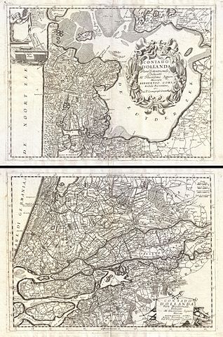
| Vincenzo Coronelli: Contado d'Ollanda Parte Settentrionale. - Contado d'Ollanda Parte Meridionale.
( |
|||||||||||||||||||||||||||
|---|---|---|---|---|---|---|---|---|---|---|---|---|---|---|---|---|---|---|---|---|---|---|---|---|---|---|---|
| Artist |
|
||||||||||||||||||||||||||
| Title |
Contado d'Ollanda Parte Settentrionale. - Contado d'Ollanda Parte Meridionale. |
||||||||||||||||||||||||||
| Description |
English: A spectacular example of Coronelli's two part map of Holland or the Netherlands. The upper sheet covers from Friesland to Amsterdam including all of the Zuyder Zee. The southern map covers from the Haarlem Meer south to Breeda and east to Batenborg. Identifies countless cities and towns throughout with larger centers appearing in block form. This map also prominently displays Holland's elaborate canal and irrigation network. Cartographically Coronelli probably drew the material for this map from earlier work by the prominent Dutch cartographers Claes Jansz Visscher or Fredrick de Wit. Each sheet has its own decorative title cartouche, though that of the upper sheet is notably more elaborate being dramatically engraved in the Italian baroque style. The upper sheet additionally boasts a second cartouche in the upper left quadrant that has been left blank - this was most likely intended for a legend that was never completed. Though this map was issued in both Coronelli's 1697 issue of the Atlante Veneto and the 1692 Corso Geográfico , we are able to firmly associate this example with the later due to its blank verso. |
||||||||||||||||||||||||||
| Date | 1692 (undated) | ||||||||||||||||||||||||||
| Dimensions | height: 35 in (88.9 cm); width: 23 in (58.4 cm) | ||||||||||||||||||||||||||
| Accession number |
Geographicus link: Holland-coronelli-1692 |
||||||||||||||||||||||||||
| Source/Photographer |
Coronelli, V. M., Corso Geográfico, 1692.
|
||||||||||||||||||||||||||
| Permission (Reusing this file) |
|
||||||||||||||||||||||||||

File history
Click on a date/time to view the file as it appeared at that time.
| Date/Time | Thumbnail | Dimensions | User | Comment | |
|---|---|---|---|---|---|
| current | 10:22, 24 March 2011 | | 4,000 × 6,034 (7.38 MB) | BotMultichillT (talk | contribs) | {{subst:User:Multichill/Geographicus |link=http://www.geographicus.com/P/AntiqueMap/Holland-coronelli-1692 |product_name=1690 Coronelli Map of Holland or the Netherlands (2 sheets) |map_title=Contado d'Ollanda Parte Settentrionale. - Contado d'Ollanda Par |
You cannot overwrite this file.
File usage on Commons
The following page uses this file:
_-_Geographicus_-_Holland-coronelli-1692.jpg)
_-_Geographicus_-_Holland-coronelli-1692.jpg&oldid=744104004)