File:1675 bird's eye view of Constantinopoli by Antonio Lafreri.tif
Jump to navigation
Jump to search

Size of this JPG preview of this TIF file: 800 × 532 pixels. Other resolutions: 320 × 213 pixels | 640 × 425 pixels | 1,024 × 680 pixels | 1,280 × 851 pixels | 2,560 × 1,701 pixels | 5,297 × 3,520 pixels.
Original file (5,297 × 3,520 pixels, file size: 53.37 MB, MIME type: image/tiff)
Captions
Captions
Add a one-line explanation of what this file represents
Summary[edit]
| Description |
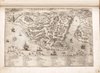
English: ga10 2006-03-10 sent to CMT Relief shown pictorially. Phillips, 3392 Each plate or leaf is numbered with pencil, pen-and-ink, or both, with some numbers crossed out. Map 79 is printed on blue paper. Strips of paper affixed to the margins of some plates. Rebound in brown leather incorporating original tooled front and back boards. Includes manuscript table of contents, which does not correspond exactly to the current arrangement of plates. Available also through the Library of Congress Web site as a raster image. |
||
| Title | Geografia tavole moderne di geografia de la maggior parte del mondo di diversi avtori raccolte et messe secondo l'ordine di Tolomeo con i disegni di molte città et fortezze di diverse provintie stampate in rame con stvdio et diligenza. | ||
| Shelf ID | G1015 .L25 1575 | ||
| Parent | https://www.loc.gov/resource/g3200m.gct00410/ | ||
| Sheet title | Constantinopoli | ||
| Date | |||
| Source | https://www.loc.gov/item/2006629143/ | ||
| Author | Lafréry, Antoine | ||
| Permission (Reusing this file) |
|
||
| Other versions | |||
| Location | Earth (Planet) · Italy · Earth (Planet). | ||
| Part of | American Memory · General Maps · Catalog · Geography And Map Division | ||
| Subject | Earth (Planet) · Atlases · Italy · Early Works To 1800 · World Atlases |

Licensing[edit]
|
This is a faithful photographic reproduction of a two-dimensional, public domain work of art. The work of art itself is in the public domain for the following reason:
The official position taken by the Wikimedia Foundation is that "faithful reproductions of two-dimensional public domain works of art are public domain".
This photographic reproduction is therefore also considered to be in the public domain in the United States. In other jurisdictions, re-use of this content may be restricted; see Reuse of PD-Art photographs for details. | ||||
File history
Click on a date/time to view the file as it appeared at that time.
| Date/Time | Thumbnail | Dimensions | User | Comment | |
|---|---|---|---|---|---|
| current | 12:01, 27 June 2020 |  | 5,297 × 3,520 (53.37 MB) | Balkanique (talk | contribs) | File:Geografia tavole moderne di geografia de la maggior parte del mondo di diversi avtori raccolte et messe secondo l'ordine di Tolomeo con i disegni di molte città et fortezze di diverse provintie LOC 2006629143-93.tif cropped 10 % horizontally, 19 % vertically using CropTool with precise mode. |
You cannot overwrite this file.
File usage on Commons
The following 2 pages use this file: