File:Εκστρατείες του Μεγάλου Αλεξάνδρου.svg
Jump to navigation
Jump to search

Size of this PNG preview of this SVG file: 800 × 433 pixels. Other resolutions: 320 × 173 pixels | 640 × 347 pixels | 1,024 × 554 pixels | 1,280 × 693 pixels | 2,560 × 1,386 pixels | 1,243 × 673 pixels.
Original file (SVG file, nominally 1,243 × 673 pixels, file size: 399 KB)
Captions
Captions
Add a one-line explanation of what this file represents
Summary[edit]
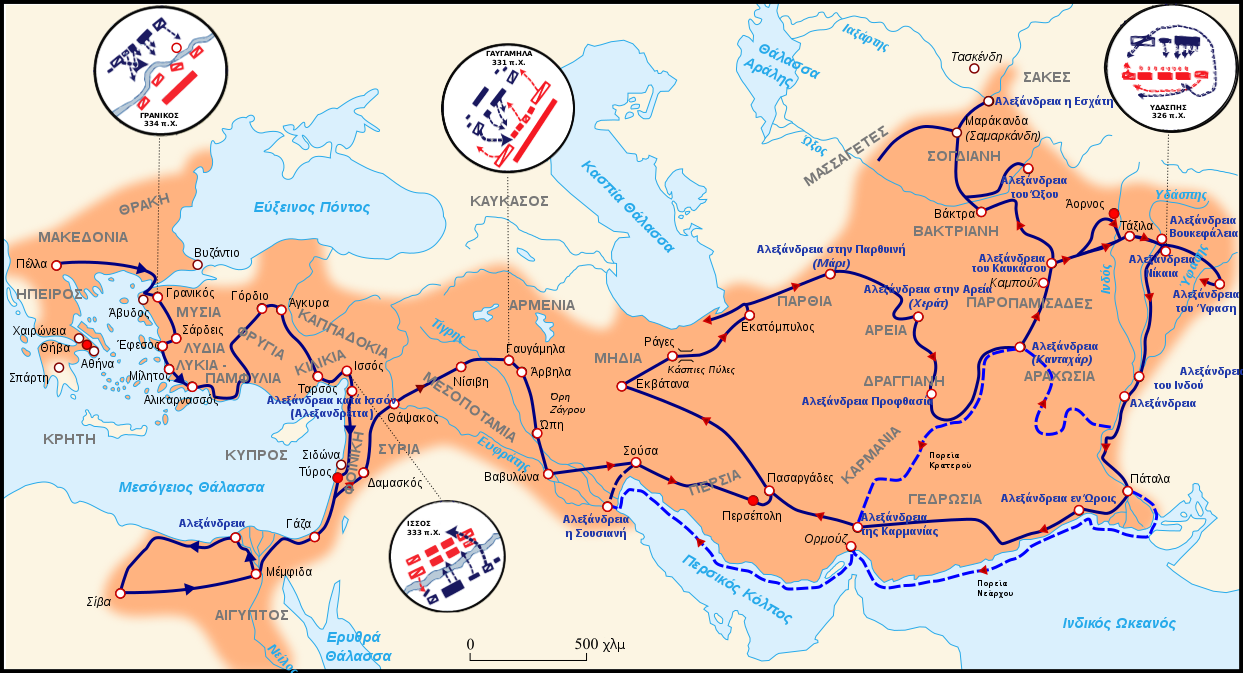
| Description |
Ελληνικά: Εκστρατείες του Μεγάλου Αλεξάνδρου, με πορεία κατεύθυνσης, απεικόνιση των σχηματισμών των κύριων μαχών, και χρωματική επισήμανση των ιδρυθείσων πόλεων
English: Campaigns of Alexander the Great, with directional arrowheads, major battle formations, and color indication of founded cities |
| Date | |
| Source |
|
| Author |
George Tsiagalakis Based on sources from: |
| Other versions |
 Πόλεις που ιδρύθηκαν από τον Μέγα_Αλέξανδρο Πόλεις που ιδρύθηκαν από τον Μέγα_Αλέξανδρο |


This W3C-unspecified vector image was created with Inkscape .
Licensing[edit]
I, the copyright holder of this work, hereby publish it under the following license:
This file is licensed under the Creative Commons Attribution-Share Alike 3.0 Unported license.
- You are free:
- to share – to copy, distribute and transmit the work
- to remix – to adapt the work
- Under the following conditions:
- attribution – You must give appropriate credit, provide a link to the license, and indicate if changes were made. You may do so in any reasonable manner, but not in any way that suggests the licensor endorses you or your use.
- share alike – If you remix, transform, or build upon the material, you must distribute your contributions under the same or compatible license as the original.
Original upload log[edit]
This image is a derivative work of the following images:
- File:MacedonEmpire.jpg licensed with Cc-by-sa-3.0-migrated, GFDL-GMT
- 2006-04-13T18:47:39Z Captain Blood 2000x961 (825270 Bytes) A. in Arachosia corr.
- 2006-03-24T17:38:35Z Captain Blood 2000x961 (825243 Bytes) {{GFDL-GMT}}
- File:Mapa_de_Alejandrías.svg licensed with Cc-by-sa-3.0
- 2009-09-26T00:17:57Z Mircalla22 1243x673 (204990 Bytes) {{Information |Description={{es}}Mapa del imperio macedónico durante el gobierno de Alejandro Magno. {{fr}}Carte de l'Empire Macédonien sous Alexandre III "Le Grand" dans l'Antiquité {{en}}Map of Macedonian Empire under Alexander III "The great" command in Antic period
- File:Imperio_de_Alejandro_Magno_con_ruta.svg licensed with Cc-by-sa-3.0
- 21:10, 10 October 2009 2009-10-10T00:10:07Z Mircalla22 1243x673 (204990 Bytes) {{Information |Description={{es}} Mapa del imperio macedónico durante el gobierno de Alejandro Magno incluyendo ruta de conquista {{fr}}Carte de l'Empire Macédonien sous Alexandre III "Le Grand" dans l'Antiquité {{en}}Map of Macedonian Empire under A
File history
Click on a date/time to view the file as it appeared at that time.
| Date/Time | Thumbnail | Dimensions | User | Comment | |
|---|---|---|---|---|---|
| current | 14:50, 1 December 2014 | | 1,243 × 673 (399 KB) | Gts-tg (talk | contribs) | Changed route colour while preserving arrowheads, couple of minor tweaks + altered marks for Kabul & Tashkent for purposes of uniformity (although smaller these cities existed at the time) |
| 22:20, 28 November 2014 |  | 1,243 × 673 (409 KB) | Dipa1965 (talk | contribs) | Corrected spelling of Greek nameplaces. Changed fonts to the loyalty-free Liberation Sans (best compatibility with Wikimedia). Corrected some locations. Added two major modern cities (Kabul, Tashkent). Used italic font and black circles for the modern... | |
| 19:50, 27 November 2014 |  | 1,243 × 673 (423 KB) | Gts-tg (talk | contribs) | User created page with UploadWizard |
You cannot overwrite this file.
File usage on Commons
The following 4 pages use this file:
File usage on other wikis
The following other wikis use this file:
- Usage on el.wikipedia.org
- Usage on hyw.wikipedia.org