London Borough of Croydon
There are many skyscrapers, structures and towers in the London Borough of Croydon, ranging from the Victorian Croydon Clocktower (now an arts centre) to 21st century luxury apartment buildings. Croydon has a population of over 330,587.[1] At its core is Croydon, a former market town, with interests in producing charcoal, tanned leather, and brewing.[2] It was heavily bombed in the Second World War mainly because of its aerodrome Croydon Airport, leading to the destruction of some buildings. Most of the city's tallest buildings are office blocks constructed during the mid-20th century. However, since then many of these office blocks have become outdated, prompting a huge redevelopment programme for the town centre, called Croydon Vision 2020. The town has since witnessed a boom in the construction of high rise apartments, such as IYLO and Altitude 25, a former brownfield site.
Geographically, commercially, and culturally, Croydon is dominated by its immediate neighbour London, whose geographic centre lies only 9.5 miles away across south London. In some ways being so close to the capital city has been good for the town, in terms of population and business growth, being named as London's Third City and London's Manhattan. But being in the suburbia of London has become a hindrance as well, in terms of tourism to the town. Some of the early high-rise buildings have subsequently been demolished themselves, such as Wettern House to allow for new skyscrapers to be constructed.[3]
borough in the London Region in England    | |||||
| Upload media | |||||
| Instance of | |||||
|---|---|---|---|---|---|
| Location | Greater London, London, England | ||||
| Capital | |||||
| Legislative body |
| ||||
| Executive body |
| ||||
| Head of government |
| ||||
| Inception |
| ||||
| Population |
| ||||
| Area |
| ||||
| Replaces |
| ||||
| Replaced by |
| ||||
| Different from | |||||
| official website | |||||
 | |||||
-

-
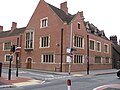
 Croydon Town Hall
 -
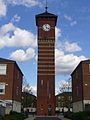
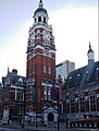 Croydon Clocktower Art Centre
 -

-
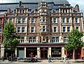
 Jurys Inn, Lansdowne Road/Wellesley Road
 -
-
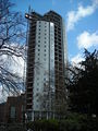
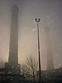
 IYLO under construction 2 June 2010
 -
 The 'Red Deer', South Croydon


Historic[edit]
The London Borough of Croydon was formed in 1965 from the the Coulsdon and Purley Urban District and the County Borough of Croydon. It is now governed by a cabinet-style council created in 2001. The name Croydon comes from Crogdene or Croindone, named by the Saxons in the 8th century when they settled here, although the area had been inhabited since pre-historic times.[4]
-

-
 Arthur Conan Doyle's house in South Norwood
 -

-
-
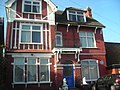
 Historic houses
 -

-
 Purley Council Offices
 -

-
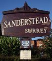 Sanderstead village sign has a representation of the church on the top of it
 -

-

-

-
 Warlingham Park Hospital Strictly speaking it is just outside the borough but it took its victims from Croydon
 -


Croydon Clocktower[edit]
The Croydon Clocktower on Katharine Street in Central Croydon is an arts centre. It contains the Museum of Croydon, the Riesco Gallery with a collection of Chinese pottery and ceramics, the David Lean Cinema, the Braithwaite Hall used for concerts and conferences, and a café and bar. The museum includes exhibits about the important black composer Samuel Coleridge-Taylor (1875-1912) who lived most of his life in Croydon. Croydon Central Library is inside the clocktower.


Retail[edit]
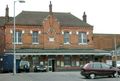
North End is the main shopping street in the borough. It is pedestrianised road holds both of the main shopping centres, Centrale and Whitgift Centre plus a forthcoming one called Park Place. Significantly, 'Westfield Shopping Centre is, as of late 2013, confirmed as moving into central Croydon and plans to bring a John Lewis into the town centre as part of its store range. The road currently offers many well-known shops such as: Waterstones, Next, Zara, French Connection, Pret a Manger and large branches of Debenhams, and House of Fraser. North End was closed off to all forms of motor traffic in 1989, to entice shoppers to choose Croydon over its main south-east London rival Bromley.
North End is the home of the only Allders left standing, after the company went into liquidation, which finally lead to the collapse of the group apart from the Croydon flagship store which opened in 1862. This Allders is the fourth largest department store in the United Kingdom and boasts the largest carpet department in Europe.
-

-
 Grants centre
 -

-
 High Street, Croydon
 -


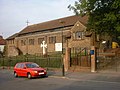
Churches[edit]
-

-
 West Croydon Baptist Church
 -
 St Paul's Church, Thornton Heath
 -
 St Alban's Church, Grange Road, Thornton Heath
 -
 The Coptic Orthodox Church of St. Mary and St. Shenouda in Rickman Hill, Coulsdon


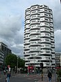
Offices and high rise luxury apartments[edit]
In contrast to the vast majority of London's tallest buildings, Croydon's high-rises were constructed in the 1960s and 70s as part of a project to create the South of England's largest office space outside of Central London.[5] That said, a number of Croydon's high-rise offices have since undergone major refurbishment and gained a more contemporary look, whilst others have been demolished and replaced by newer buildings. There are plans to build more new high-rises (generally luxury apartments as opposed to offices), some over 50 storeys, eg 1 Landsdowne Road.
-

-

-

-
 Offices in East Croydon
 -
 Office entrance
 -

-

-

-
-

-
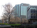 Modern offices
 -
 Altitude 25, a 25 storey luxury apartment building completed circa 2010
 -
 Saffron Square development in Wellesley Road (final completion early 2016).


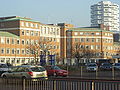
Schools[edit]
The London Borough of Croydon is one of the boroughs in London with the most schools. They include primary schools (95), secondary schools (21) and three further education establishments.[6] Croydon College has its main building in Central Croydon, it is a high rise building.[7] John Ruskin College[8] is one of the other colleges in the borough, located in Addington and Coulsdon College[9] in Coulsdon. The London Borough of Croydon is the local education authority for the borough.
-

-
-
 Old Palace School (Croydon Palace)


.JPG)
Parks[edit]
The London Borough of Croydon has over 120 parks and open spaces within its boundaries, ranging from the 200 acre (80ha) Selsdon Wood Nature Reserve to many recreation grounds and sports fields scattered throughout the Borough. Some of the open spaces in Croydon form part of the well-known London LOOP walks where the first section was opened on May 3, 1996, with a ceremony on Farthing Downs in Coulsdon. As a borough in Outer London it also contains some open countryside in the form of country parks. Croydon Council is associated with several other boroughs who are taking part in the Downlands Countryside Management Project.


Transport[edit]
Croydon is a hub for transport, and is one of the most commuter friendly places to live in London. The old London to Brighton road, the A23, passes through the west of the borough on Purley Way, the retail district of Croydon which includes an IKEA store. The M25 motorway forms part of the boundary of the borough. The M23 motorway also starts at the very south of the borough and borders Tandridge.
Air[edit]
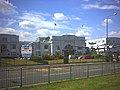
Croydon Airport was in Purley Way straddled the boundary between what are now the London boroughs of Croydon and Sutton. It was the main airport for London before it was replaced by Northolt Aerodrome, Heathrow and Gatwick.
-
 Airport House, the remains of the airport terminal buildings
 -
 Preserved de Havilland Heron ouside of Airport House
_-_geograph.org.uk_-_33436.jpg)

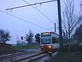
Trams[edit]
- See also Tramlink
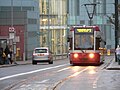
Croydon is the hub of Tramlink services. The highly successful environmentally-friendly and reliable light rail system carries around 22 million passengers a year. It is the only tram system in London: once called the Croydon Tramlink, the name was changed due to expansion.
-

-

-

-

-

-
 Tram in Croydon town centre
 -
 Tram in traffic at West Croydon
 -
 Tram going past Centrale
 -
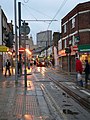 Tram on Croydon high street
 -


Railway[edit]
South London has an extensive railway network, the busiest in London. The main line through Croydon is the Brighton Main Line from Victoria and London Bridge station to Sussex, Surrey and Kent. The main operator of services in the borough is Southern and others include Southeastern, First Capital Connect and CrossCountry. East Croydon station is the largest and busiest station in Croydon, third busiest in London, excluding Travelcard Zone 1. A pilot scheme launched by the SRA, TFL and three train operators is designed to encourage more passengers to travel off-peak. In full partnership with the South London Boroughs, including Croydon, SWELTRAC, SELTRANS and the transport users group, the scheme promotes the advantages of off-peak travel following improvements to safety, travel connections and upgrading of station facilities.
-
 Map of lines in the Croydon area before 1911
 -

-

-

-
-

-

-
-

-
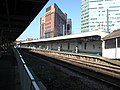


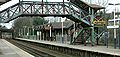
East Croydon station[edit]
-

-
 Tramlink at East Croydon
 -
 Station concourse
 -
 Station frontage


Skyline[edit]

See also[edit]
- A gallery of images of Sanderstead
References[edit]
- ↑ Key Figures for 2001 Census: Census Area Statistics. National Statistics (2001). Archived from the original on 2011-06-12. Retrieved on 2007-10-11.
- ↑ Basic History of Croydon. Croyweb (2004). Retrieved on 2007-09-25.
- ↑ Supplementary Planning Guidance. Croydon Council. Archived from the original on 2008-08-30. Retrieved on 2008-03-23.
- ↑ Croydon: Introduction and Croydon Palace. British History Online (2006). Retrieved on 2007-10-12.
- ↑ Salford. Skyscraperpage.com. Retrieved on 2008-02-26.
- ↑ London Borough of Croydon: Education and learning
- ↑ Croydon College: About the College. Archived from the original on 2007-07-13. Retrieved on 2008-03-24.
- ↑ John Ruskin College
- ↑ Home - Coulsdon College website