| name
|
ID
|
located in the administrative territorial entity
|
location
|
coordinate location
|
image
|
Akolan tila   
(agricultural environment)
|
1314
|
. . Ii
|
|
65°20′16″N 25°23′04″E / 65.337899°N 25.384566°E / 65.337899; 25.384566
|
 Upload an image of this heritage site Upload an image of this heritage site
|
Ala-Temmeksen jokivarsitalot
(riverside settlement)
|
1421
|
. . Liminka
|
|
64°45′55″N 25°32′38″E / 64.765208242°N 25.543987886°E / 64.765208242; 25.543987886
|
Upload an image of this heritage site
|
Haapajärven kirkkoranta
(landscape of religious buildings)
|
1407
|
. . Haapajärvi
|
|
|
Upload an image of this heritage site
|
Haapasepän tila ja Temmeksen kirkko
(agricultural environment)
|
2075
|
. Temmes. Tyrnävä
|
|
|
Upload an image of this heritage site
|
Haapaveden Vanhatien raitti
(historic road)
|
1408
|
. . Haapavesi
|
|
|
Upload an image of this heritage site
|
Haapavesi college
(agricultural environment
educational institution)
|
1409
|
. . Haapavesi
|
|
|
Upload an image of this heritage site
|
Hailuoto
(island)
|
1394
|
. . Hailuoto
|
|
65°02′00″N 24°42′00″E / 65.03333055555555°N 24.7°E / 65.03333055555555; 24.7
|
 
|
Halosenniemi Sawmill
(sawmill)
|
278
|
. Halosenniemi. Oulu
|
|
65°14′39″N 25°19′47″E / 65.244096207°N 25.329809514°E / 65.244096207; 25.329809514
|
Upload an image of this heritage site
|
Haukiputaan kirkko ympäristöineen
(landscape of religious buildings)
|
2076
|
. Haukipudas village. Oulu
|
|
|
Upload an image of this heritage site
|
Hietasaaren huvila-alue
(villa area)
|
2091
|
. Hietasaari. Oulu
|
|
65°01′15″N 25°25′41″E / 65.020765768°N 25.427994504°E / 65.020765768; 25.427994504
|
Upload an image of this heritage site
|
Honkakosken tila
(heritage site
Kronohemman)
|
1393
|
. . Tyrnävä
|
|
|
Upload an image of this heritage site
|
Huttusen laatikko
(cultural landscape)
|
5168
|
. . Oulu
|
|
65°00′29″N 25°28′25″E / 65.007927965°N 25.473517708°E / 65.007927965; 25.473517708
|
Upload an image of this heritage site
|
Iin Haminan vanha satama- ja kauppapaikka
(water traffic site)
|
1311
|
. . Ii
|
|
|
Upload an image of this heritage site
|
Iso-Kraaselin ja Taskun tunnusmajakat
(water traffic site)
|
2920
|
. . Raahe
|
|
|
Upload an image of this heritage site
|
Jylkän talonpoikaistila
(agricultural environment)
|
2199
|
. . Kalajoki
|
|
|
Upload an image of this heritage site
|
Kalajoen pappila
(landscape of religious buildings)
|
5263
|
. . Kalajoki
|
|
|
Upload an image of this heritage site
|
Kalajokivarsi Ylivieskan keskustassa ja Savisilta
(riverside settlement)
|
172
|
. . Ylivieska
|
|
|
Upload an image of this heritage site
|
Kalapudas
(village)
|
1420
|
. . Merijärvi
|
|
64°18′02″N 24°33′36″E / 64.300438°N 24.560009°E / 64.300438; 24.560009
|
Upload an image of this heritage site
|
Kallankari Islands
(island
autonomous administrative territorial entity)
|
1313
|
. . Kalajoki
|
|
64°19′00″N 23°30′00″E / 64.316666666667°N 23.5°E / 64.316666666667; 23.5
|

|
Kallioniemi
(house museum
house)
|
4551
|
. Jokijärvi. Taivalkoski
|
|
65°30′04″N 28°34′31″E / 65.501222°N 28.575389°E / 65.501222; 28.575389
|

|
Kankaanpääntien kylämaisema
(village)
|
4342
|
. . Lumijoki
|
|
|
Upload an image of this heritage site
|
Karjasilta
(district of Oulu)
|
2092
|
. . Oulu
|
|
65°00′06″N 25°29′38″E / 65.001666666667°N 25.493888888889°E / 65.001666666667; 25.493888888889
|
 
|
Kempeleen kirkonmäki
(landscape of religious buildings)
|
1410
|
. . Kempele
|
|
|
Upload an image of this heritage site
|
Kiimingin kirkko ympäristöineen
(landscape of religious buildings)
|
1321
|
. . Oulu
|
|
|
Upload an image of this heritage site
|
Korhoskylä
(village
asemakylä)
|
4363
|
. . Sievi
|
|
|
Upload an image of this heritage site
|
Kyösti ja Kalervo Kallion talot
(cultural landscape)
|
2232
|
. . Nivala
|
|
|
Upload an image of this heritage site
|
Kärsämä
(exclave
village in Finland)
|
4549
|
. . Siikalatva
|
|
64°32′28″N 25°47′25″E / 64.54115556111111°N 25.79020293888889°E / 64.54115556111111; 25.79020293888889
|
Upload an image of this heritage site
|
Kärsämäki Church
(church building)
|
1322
|
. . Kärsämäki
|
|
63°58′43″N 25°46′00″E / 63.9786°N 25.7667°E / 63.9786; 25.7667
63°58′43″N 25°46′00″E / 63.97863343°N 25.7667075°E / 63.97863343; 25.7667075
|

|
Köyhänperän latoalue
(agricultural environment)
|
4386
|
. . Nivala
|
|
63°52′54″N 25°04′21″E / 63.881577847°N 25.072562563°E / 63.881577847; 25.072562563
|
Upload an image of this heritage site
|
Lamminaho House
(farmhouse
museum farm
open-air museum
farm)
|
957
|
. . Vaala
|
|
64°35′11″N 26°44′18″E / 64.586391°N 26.738253°E / 64.586391; 26.738253
|

|
Lapinkylän tuulimyllyt
(cultural landscape)
|
3996
|
. . Lumijoki
|
|
|
Upload an image of this heritage site
|
Limingan Ranta
(residential area)
|
1412
|
. . Liminka
|
|
|
Upload an image of this heritage site
|
Limingan kirkko ympäristöineen
(landscape of religious buildings)
|
1323
|
. . Liminka
|
|
|

|
Linnanmaa campus
(university campus)
|
5064
|
. Linnanmaa. Oulu
|
|
65°03′33″N 25°27′58″E / 65.059166666667°N 25.466111111111°E / 65.059166666667; 25.466111111111
|

|
Maikkula reserve company
(historical military facility
barracks)
|
1395
|
. . Oulu
|
|
|

|
Martinniemi Sawmill
(sawmill)
|
4137
|
. Martinniemi. Oulu
|
|
65°12′58″N 25°17′14″E / 65.216222222222°N 25.287333333333°E / 65.216222222222; 25.287333333333
|

|
Mattilanperän kylä
(village)
|
4334
|
. . Alavieska
|
|
64°06′55″N 24°18′09″E / 64.11529722222222°N 24.30245°E / 64.11529722222222; 24.30245
|
Upload an image of this heritage site
|
Montta power plant
(hydroelectric power station)
|
1292
|
. Montta. Muhos
|
|
64°49′15″N 26°00′52″E / 64.820833333333°N 26.014444444444°E / 64.820833333333; 26.014444444444
|

|
Muhos Church
(parish church
church building)
|
4346
|
. Muhos parish village. Muhos
|
|
64°48′56″N 25°59′16″E / 64.8156°N 25.9878°E / 64.8156; 25.9878
64°48′57″N 25°59′16″E / 64.81573635°N 25.98774493°E / 64.81573635; 25.98774493
64°48′57″N 25°59′16″E / 64.8157264°N 25.9877138°E / 64.8157264; 25.9877138
|

|
Naamangan kylä
(village)
|
4353
|
. . Pudasjärvi
|
|
65°34′26″N 27°39′56″E / 65.57376976°N 27.665661067°E / 65.57376976; 27.665661067
|
Upload an image of this heritage site
|
Nikolan umpipiha
(cultural landscape)
|
1414
|
. . Siikajoki
|
|
|
Upload an image of this heritage site
|
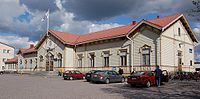
Oulainen railway station
(railway station
rail yard
station located on surface)
|
4195
|
. . Oulainen
|
|
64°16′10″N 24°49′17″E / 64.26953°N 24.82128°E / 64.26953; 24.82128
|

|
Oulu Cemetery
(cemetery)
|
1418
|
. Intiö. Oulu
|
|
65°00′46″N 25°29′29″E / 65.0128°N 25.4914°E / 65.0128; 25.4914
|

|
Oulu Prison
(prison)
|
936
|
. Myllytulli. Oulu
|
|
65°01′05″N 25°29′22″E / 65.0181°N 25.489444444444°E / 65.0181; 25.489444444444
|

|
Oulu Town Canal Park Zone
(park)
|
4488
|
. Keskustan suuralue. Oulu
|
|
|

|
Oulu railway station
(railway station
rail yard
station located on surface
junction station)
|
4194
|
11a Rautatienkatu. Vaara. Oulu
|
|
65°00′41″N 25°29′02″E / 65.01142201°N 25.48397964°E / 65.01142201; 25.48397964
|
|
Oulu sniper barracks
(historical military facility)
|
1426
|
. . Oulu
|
|
65°01′09″N 25°29′58″E / 65.01913°N 25.499496°E / 65.01913; 25.499496
|

|
Oulujoen ja Sotkamon reitin voimalaitokset
(industrial landscape)
|
1292
|
. Montta. Oulu
Vaala
Utajärvi
Muhos
|
|
|
Upload an image of this heritage site
|
Oulujoen suistoalueen historiallinen kokonaisuus
(cultural landscape)
|
2081
|
. . Oulu
|
|
|
Upload an image of this heritage site
|
Oulujoki Church
(church building)
|
4486
|
. Kirkkokangas. Oulu
|
|
65°00′20″N 25°33′47″E / 65.00543513°N 25.56299428°E / 65.00543513; 25.56299428
65°00′19″N 25°33′47″E / 65.0054162°N 25.5629972°E / 65.0054162; 25.5629972
|

|
Oulun rantakortteleiden julkinen kaupunkitila
(urban landscape)
|
1474
|
. . Oulu
|
|
|
Upload an image of this heritage site
|
Oulun vanha monumentaalikeskus ja Franzénin puisto
(urban landscape)
|
2077
|
. . Oulu
|
|
|
Upload an image of this heritage site
|
Paavola church landscape
(landscape of religious buildings)
|
4360
|
. Paavola
Paavola. Siikajoki
|
|
|
Upload an image of this heritage site
|
Pateniemi Sawmill
(sawmill)
|
336
|
. Pateniemi. Oulu
|
|
65°05′08″N 25°23′53″E / 65.085615988°N 25.398122672°E / 65.085615988; 25.398122672
|
Upload an image of this heritage site
|
Piippola
(urban area in Finland
village with a church
village in Finland)
|
2068
|
. . Siikalatva
|
|
64°10′39″N 25°57′58″E / 64.1775°N 25.96611111111111°E / 64.1775; 25.96611111111111
|
Upload an image of this heritage site
|
Plassin vanha markkinapaikka
(cultural landscape)
|
1312
|
. . Kalajoki
|
|
64°16′06″N 23°55′53″E / 64.268336823°N 23.931515185°E / 64.268336823; 23.931515185
|
Upload an image of this heritage site
|
Pohjanmaa Coastal Road
(historic road
tourist route in Finland)
|
4372
|
. . Raahe
Pyhäjoki
Ii
Kalajoki
Siikajoki
Lumijoki
Oulu
|
|
|

|
Pohjanmaan teollisuuden kartanot
(manor environment)
|
4736
|
. . Ii
|
|
|
Upload an image of this heritage site
|
Pudasjärven kirkkomaisema
(landscape of religious buildings)
|
2016
|
. . Pudasjärvi
|
|
|
Upload an image of this heritage site
|
Pyhäjoen kalarannat
(cultural landscape)
|
1392
|
. . Pyhäjoki
|
|
|
Upload an image of this heritage site
|
Pyramidikattoiset kesänavetat
(cultural landscape)
|
2107
|
. . Kuusamo
Ii
Pudasjärvi
Oulu
|
|
|
Upload an image of this heritage site
|
Päivärinne Sanatorium
(hospital)
|
4347
|
. Päivärinne. Muhos
|
|
64°52′56″N 25°51′50″E / 64.88219325539917°N 25.863937564241105°E / 64.88219325539917; 25.863937564241105
|

|
Raahe seminar
(university campus
educational institution)
|
5082
|
. . Raahe
|
|
64°41′37″N 24°28′05″E / 64.693473°N 24.468165°E / 64.693473; 24.468165
64°41′37″N 24°28′02″E / 64.6934884°N 24.4672016°E / 64.6934884; 24.4672016
|

|
Raahen Pekkatori ja ruutukaava-alueen puutalokorttelit
(urban landscape)
|
1462
|
. . Raahe
|
|
|
Upload an image of this heritage site
|
Raahen rautatieasema ja tullikamari
(railway environment)
|
4196
|
. . Raahe
|
|
|
Upload an image of this heritage site
|
Rajaniemen kylä
(village)
|
1398
|
. . Pyhäjoki
|
|
64°26′39″N 24°08′51″E / 64.444104234°N 24.147493692°E / 64.444104234; 24.147493692
|
Upload an image of this heritage site
|
Raksilan puutaloalue
(residential area)
|
5105
|
. . Oulu
|
|
|
Upload an image of this heritage site
|
Rantsilan kirkko ja vanha raitti
(landscape of religious buildings)
|
1329
|
. Rantsila. Siikalatva
|
|
|
Upload an image of this heritage site
|
Raumankarin vanha asutus ja Himangan kirkko
(landscape of religious buildings)
|
1640
|
. Himanka. Kalajoki
|
|
|
Upload an image of this heritage site
|
Ruukki Rural Institute
(educational institution)
|
4324
|
. . Siikajoki
|
|
64°41′02″N 25°05′09″E / 64.684026942°N 25.085744761°E / 64.684026942; 25.085744761
|
Upload an image of this heritage site
|
Röyttä
(island)
|
2919
|
. . Ii
|
|
65°16′36″N 25°12′29″E / 65.27653333°N 25.20808333°E / 65.27653333; 25.20808333
|

|
Sahanseudun Katinhännän asuinalue
(industrial heritage site)
|
4848
|
. . Siikajoki
|
|
64°38′55″N 25°07′08″E / 64.648572325°N 25.118771543°E / 64.648572325; 25.118771543
|
Upload an image of this heritage site
|
Saloisten kellotapuli
(cultural landscape)
|
1327
|
. . Raahe
|
|
|
Upload an image of this heritage site
|
Salpa Line
(historical military facility
fortified line)
|
2021
|
. . Kuusamo
|
|
|

|
Saviselkä–Piippola Museum Road
(museum road)
|
1411
|
. . North Ostrobothnia
|
|
64°04′10″N 26°02′44″E / 64.0694°N 26.04563°E / 64.0694; 26.04563
|

|
Siikajoen kirkko ympäristöineen
(landscape of religious buildings)
|
1330
|
. . Siikajoki
|
|
|
Upload an image of this heritage site
|
Siikajoki rafting canal
(canal)
|
1308
|
. . Vaala
|
|
64°25′52″N 26°38′14″E / 64.431111°N 26.637222°E / 64.431111; 26.637222
|
Upload an image of this heritage site
|
Toppilan satama ja teollisuusalue
(industrial heritage site)
|
2080
|
. . Oulu
|
|
|
Upload an image of this heritage site
|
Turkansaari Open Air Museum
(open-air museum
museum)
|
4687
|
165 Turkansaarentie. Madekoski. Oulu
|
|
64°56′54″N 25°42′25″E / 64.94833333°N 25.70694444°E / 64.94833333; 25.70694444
|

|
Tyrnävän Meijeritie
(historic road)
|
3997
|
. . Tyrnävä
|
|
64°45′44″N 25°38′43″E / 64.762147603°N 25.645337496°E / 64.762147603; 25.645337496
|
Upload an image of this heritage site
|
Ulkokrunnin lighthouse and pilot station
(lighthouse
pilot station)
|
2918
|
. . Ii
|
|
65°23′21″N 24°50′20″E / 65.389055555556°N 24.838861111111°E / 65.389055555556; 24.838861111111
|
Upload an image of this heritage site
|
Vaala railway station
(railway station)
|
4199
|
. . Vaala
|
|
64°33′29″N 26°50′33″E / 64.558055555556°N 26.8425°E / 64.558055555556; 26.8425
|

|
Vareksen tila
(farm)
|
2074
|
. . Siikalatva
|
|
|
Upload an image of this heritage site
|
Varjakan saha
(sawmill)
|
4352
|
. . Oulu
|
|
|
Upload an image of this heritage site
|
Vihanti mine
(mine)
|
1456
|
. Lampinsaari. Raahe
|
|
64°24′35″N 25°08′22″E / 64.40983333°N 25.13947222°E / 64.40983333; 25.13947222
|

|
Vuotungin kylä
(village)
|
3931
|
. . Kuusamo
|
|
66°08′48″N 29°34′58″E / 66.146731141°N 29.582889706°E / 66.146731141; 29.582889706
|
Upload an image of this heritage site
|
Vähäkangas
(village)
|
4370
|
. . Ylivieska
|
|
64°03′55″N 24°40′30″E / 64.065299758°N 24.674940646°E / 64.065299758; 24.674940646
|
Upload an image of this heritage site
|
Ylikiiminki Church
(church building)
|
1331
|
. Ylikiiminki. Oulu
|
|
65°01′47″N 26°07′36″E / 65.029833333333°N 26.126583333333°E / 65.029833333333; 26.126583333333
65°01′47″N 26°07′36″E / 65.029852°N 26.12658838°E / 65.029852; 26.12658838
65°01′47″N 26°07′36″E / 65.0298428°N 26.126599°E / 65.0298428; 26.126599
|

|
museum bridge
()
|
4845
|
. . Raahe
Pyhäjoki
Muhos
|
|
|

|
route d'Ossoudarev
(historic road)
|
1391
|
. . Vaala
Utajärvi
Muhos
|
|
|
Upload an image of this heritage site
|


