Commons:Wiki4Alps/Sierre
Jump to navigation
Jump to search
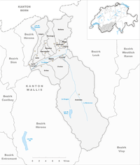
Map of Sierre

List of the cultural heritage of the district of Sierre in the Canton Valais[edit]

List of Monuments in the district of Sierre in the Canton Valais.
Update: 31 August 2018
List[edit]
| KGS-Nr | Upload | Foto | Object | Other | Cov. | Cat. | Type | Address | Town | Coordinates | |||
|---|---|---|---|---|---|---|---|---|---|---|---|---|---|
| 9699 | 
|
Ilôt Bosquet/Chlasche, Pierre à cupules | A | F | Grimentz | Anniviers |
| ||||||
| 7106 | 
|
Groupe des 5 moulins | A | G | Route d’Ayer, Saint-Luc | Anniviers |
| ||||||
| 7107 | 
|
Maison bourgeoisiale | B | G | Rue du Cervin, Saint-Luc | Anniviers |
| ||||||
| 6769 | 
|
Maison bourgeoisiale (collections) | B | S | Rue du Village, Grimentz | Anniviers |
| ||||||
| 7101 | 
|
Chapelle Saint-Jean (mobilier) | B | G | Saint-Jean en Bas, Saint-Jean | Anniviers |
| ||||||
| 7100 | 
|
Chapelle Saint-Symphorien | B | G | Pinsec, Saint-Jean | Anniviers |
| ||||||
| 7204 | .jpg)
|
Chpelle Sainte-Marie du Château avec archives | B | G | Route des Landoux, Vissoie | Anniviers |
| ||||||
| 6689 | 
|
Église Sainte-Barbe | B | G | Déjo Vella, Chandolin | Anniviers |
| ||||||
| 7206 | .jpg)
|
Église Sainte-Euphémie | B | G | Place de la Poste, Vissoie | Anniviers |
| ||||||
| 6768 | 
|
Les Trois Caves Blanches | B | G | Route de Moiry, Grimentz | Anniviers |
| ||||||
| 7205 | 
|
Cure | B | G | Place de la Poste 4, Vissoie | Anniviers |
| ||||||
| 7108 | 
|
Pierre des Sauvages (grand pierreà cupules) | B | F | Saint-Luc | Anniviers |
| ||||||
| 7207 | .jpg)
|
Tour et musée | B | G/S | Place de la Tour, Vissoie | Anniviers |
| ||||||
| 7208 | 
|
Vicariat | B | G | Place de la Poste 5, Vissoie | Anniviers |
| ||||||
| 6680 | Ancien Chalet et Chapelle de Chastonay | B | G | Chemin d’Orzival, Vercorin | Chalais |
| |||||||
| 6681 | Clocher et choeur de l'ancienne église | B | G | Rue de l’Église, Vercorin | Chalais |
| |||||||
| 6677 | 
|
Les Granges | B | G | Rue de la Laiterie | Chalais |
| ||||||
| 6678 | Maison Siegen | B | G | Route du Tombec, Réchy | Chalais |
| |||||||
| 6692 | 
|
Pont de fer sur le Rhône | B | G | Grande Avenue | Chippis |
| ||||||
| 13913 | 
|
Site industriel d'Alusuisse, rive gauche, avec usine hydroélectrique | B | G | Rue de l’Industrie | Chippis |
| ||||||
| 6691 | 
|
Église Saint-Urban et école | B | G | Rue Saint-Urbain | Chippis |
| ||||||
| 6772 | Château Morestel (maison de commune) | B | G | Rue du Château 10 | Grône |
| |||||||
| 6773 | Sägewerk | B | G | Scierie, Loye | Grône |
| |||||||
| 6774 | Refuge de la Vallée de Rechy | B | F | Route du Bisse Morété | Chippis |
| |||||||
| 6797 | 
|
Église Saint-Pierre et clocher | B | G | Chemin du Dailly | Lens, Switzerland |
| ||||||
| 6798 | 
|
Le Manoir | B | G | Chemin du Châtelard 18 | Lens, Switzerland |
| ||||||
| 6799 | 
|
Statue monumentale du Christ-Roi et site préhistorique du Châtelard | B | F/K | Le Châtelard | Lens, Switzerland |
| ||||||
| 6800 | 
|
Maison peinte (ancienne auberge) | B | G | Chemin du Tsaretton, Vaas | Lens, Switzerland |
| ||||||
| 6850 | 
|
Pont voûté sur la Raspille | B | G | Route des Marais | Miège |
| ||||||
| 6853 | Roches des Fées | A | G | Route de l’Aminona | Mollens |
| |||||||
| 6851 | Église de Saint-Maurice-de-Laques avec la cure | B | G | Route de l’Église | Mollens |
| |||||||
| 6852 | Grenier en pierre | B | G | Ruelle du Grenier 6 | Mollens |
| |||||||
| 10361 | Hotel Bella Lui | A | G | Montana-Station 21 | Montana |
| |||||||
| 10576 | Sanatorium La Moubra | B | G | Route de la Moubra 43 | Montana |
| |||||||
| 14951 | Tour Super-Crans | B | G | Randogne |
| ||||||||
| 9702 | Crête des Barmes, gravures rupestres néolithiques | A | F | Les Planisses | Saint-Léonard |
| |||||||
| 7103 | 
|
Altes Pfarrhaus | B | G | Rue du Château | Saint-Léonard |
| ||||||
| 7104 | Gravures rupestres en dessus du lac souterrain | B | F | Route du Simplon | Saint-Léonard |
| |||||||
| 7105 | 
|
Maison Zen-Ruffinen | B | G | Rue du Château 1/3 | Saint-Léonard |
| ||||||
| 7007 | 
|
Central électrique et bâtiments Alusuisse, Chippis | A | G | Route de Sous-Géronde | Sierre |
| ||||||
| 7013 | 
|
Granges, Puits | B | G | Rue du Coin | Sierre |
| ||||||
| 7003 | 
|
Château Bellevue (Hôtel de ville) | B | G | Rue du Bourg 14 | Sierre |
| ||||||
| 7004 | 
|
Château de Villa | B | G | Rue Sainte-Catherine 2 | Sierre |
| ||||||
| 7005 | 
|
Château des Vidomnes | B | G | Rue du Bourg 24 | Sierre |
| ||||||
| 7006 | 
|
Château Mercier (1908) avec jardin | B | G | Montée du Château 19 | Sierre |
| ||||||
| 7010 | 
|
Géronde, couvent, église et site | B | G | Chemin des Bernardines 53 | Sierre |
| ||||||
| 7011 | 
|
Géronde, ruine de la chapelle St-Félix | B | F/G | Chemin des Bernardines | Sierre |
| ||||||
| 7014 | Grottes de Géronde | B | G | Routes des Falaises | Sierre |
| |||||||
| 7002 | 
|
Chapelle Saint-Ginier | B | G | Rue de Saint-Ginier | Sierre |
| ||||||
| 7008 | 
|
Église Notre-Dame des Marais | B | G | Rue de Tservetta 317 | Sierre |
| ||||||
| 7009 | 
|
Église Sainte-Catherine | B | G | Rue du Bourg 315 | Sierre |
| ||||||
| 10611 | 
|
Clinique Sainte-Claire | B | G | Rue de Plantzette 51 | Sierre |
| ||||||
| 7015 | 
|
Maison de Chastonay/Glarey | B | G | Route du Simplon 35 | Sierre |
| ||||||
| 7016 | 
|
Maison Pancrace de Courten et archives de la fondation Rainer Maria Rilke | B | G | Rue du Bourg 30 | Sierre |
| ||||||
| 7012 | 
|
Granges, colline des Châteaux | B | F/G | Route de la Crête-Blanche, Granges | Sierre |
| ||||||
| 7018 | 
|
Tour de Goubing | B | G | Chemin de Goubing 24 | Sierre |
| ||||||
| 10704 | 
|
Musée valaisan de la vigne et du vin | B | S | Rue Sainte-Catherine 6 | Sierre |
| ||||||
| 8747 | Collection d’étains dans l'Hôtel de ville | B | S | Rue du Bourg 14 | Sierre |
| |||||||
| 7163 | Tour | A | G | Rue du Château | Venthône |
| |||||||
| 7160 | 
|
Château des Anchettes avec greniers, raccards et chapelle (ensemble) | B | G | Route d’Anchettes | Venthône |
| ||||||
| 7162 | 
|
Église Saint-Sébastien | B | G | Rue du Château | Venthône |
| ||||||
| 7161 | Cure (ancienne tour Vareilli) | B | G | Route du Village 14b | Venthône |
| |||||||
| 7178 | 
|
Tour médiévale (Rilke) | B | G | Route du Moulin, Muzot | Veyras |
| ||||||
| 7176 | 
|
Chapelle Saint-François | B | G | Avenue Saint-François | Veyras |
| ||||||
| 7177 | 
|
Chapelle Sainte-Marie | B | G | Route du Moulin, Muzot | Veyras |
|