Commons:Featured picture candidates/File:Plan de Paris en 1657.JPG
Jump to navigation
Jump to search

File:Plan de Paris en 1657.JPG, featured[edit]
Voting period is over. Please don't add any new votes.Voting period ends on 11 Jan 2011 at 16:37:57 (UTC)
Visit the nomination page to add or modify image notes.

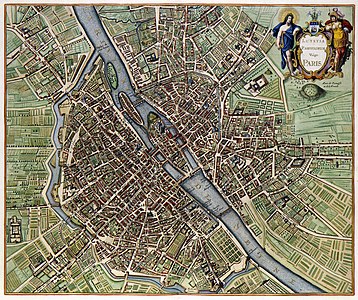
 Info created by Johannes Janssonius - uploaded by Thesupermat - nominated by Paris 16 (talk) 16:37, 2 January 2011 (UTC)
 Support -- Paris 16 (talk) 16:37, 2 January 2011 (UTC)
- Support --IdLoveOne (talk) 21:03, 2 January 2011 (UTC)
- Support Very high quality : I can see my house ! --Jebulon (talk) 23:52, 2 January 2011 (UTC)
- Support this first version of google earth.--Garrondo (talk) 07:37, 3 January 2011 (UTC)
- Support --Schnobby (talk) 09:37, 3 January 2011 (UTC)
- Support --Cayambe (talk) 17:31, 3 January 2011 (UTC)
- Support Good quality given the age of the plan (354 years old), but otherwise I wouldn´t support it.--Snaevar (talk) 22:41, 3 January 2011 (UTC)
- Support--MrPanyGoff 10:15, 4 January 2011 (UTC)
- Support It's my city...! --Citron (talk) 11:28, 4 January 2011 (UTC)
- Support Very nice quality. Steven Walling 08:25, 5 January 2011 (UTC)
- Support --ComputerHotline (talk) 19:48, 5 January 2011 (UTC)
- InfoBizarre : le nord est au sud ouest.--Pline (talk) 18:05, 6 January 2011 (UTC)
 Oppose Very nice copy of a historical map by a great cartographer. Unfortunately, the reproduction is not that good: chromatic aberration (especially in the upper part and upper left corner) and several disturbing dusts in the cartouche. -- MJJR (talk) 22:24, 6 January 2011 (UTC)
- Support --Michael Gäbler (talk) 23:23, 6 January 2011 (UTC)
- Support--shizhao (talk) 08:50, 11 January 2011 (UTC)
- Oppose Lots of great detail, but the chromatic aberration is too strong for me. --Avenue (talk) 13:00, 11 January 2011 (UTC)
Confirmed results:
Result: 13 support, 2 oppose, 0 neutral → featured. /George Chernilevsky talk 17:11, 11 January 2011 (UTC)
This image will be added to the FP gallery: Non-photographic media/Maps