Category:Zuiderhaven 2, Harlingen
Jump to navigation
Jump to search
| Object location | | View all coordinates using: OpenStreetMap |
|---|
 | |||||
| Upload media | |||||
| Instance of |
| ||||
|---|---|---|---|---|---|
| Location | Harlingen, Friesland, Netherlands | ||||
| Located on street | |||||
| Owned by |
| ||||
| Heritage designation |
| ||||
| Inception |
| ||||
 | |||||
|
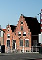
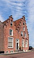
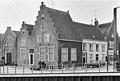
This is a category about rijksmonument number 20789
|
| Address |
|
Media in category "Zuiderhaven 2, Harlingen"
The following 12 files are in this category, out of 12 total.
-
 Exterieur OVERZICHT - Harlingen - 20269905 - RCE.jpg 1,197 × 1,200; 310 KB
-
 Exterieur OVERZICHT, VOORGEVELS - Harlingen - 20269906 - RCE.jpg 1,200 × 1,200; 340 KB
-
 Harlingen, Zuiderhaven 2.JPG 1,671 × 2,401; 1.14 MB
-
 Harlingen. Zuiderhaven 2. 12-07-2021. (actm.) 01.jpg 2,318 × 3,090; 6.8 MB
-
 Harlingen. Zuiderhaven 2. 12-07-2021. (actm.) 02.jpg 2,729 × 4,610; 12.04 MB
-
 INTERIEUR, GROTE KAMER - Harlingen - 20269907 - RCE.jpg 1,195 × 1,200; 226 KB
-
 Overzicht even zijde - Harlingen - 20101815 - RCE.jpg 1,200 × 950; 282 KB
-
 Voor- en zijgevel - Harlingen - 20101821 - RCE.jpg 1,200 × 811; 203 KB
-
 Voorgevel - Harlingen - 20102360 - RCE.jpg 949 × 1,200; 232 KB
-

-
 Zicht over het water - Harlingen - 20102356 - RCE.jpg 928 × 1,200; 207 KB
-
 Zicht over het water - Harlingen - 20379998 - RCE.jpg 859 × 1,200; 173 KB


_01.jpg)
_02.jpg)


