Category:Wisconsin Highway 54
Jump to navigation
Jump to search
 | number: | (fifty-four) |
|---|---|---|
| State highways in Wisconsin: | 34 · 35 · 36 · 37 · 38 · 39 · 40 · 42 · 44 · 46 · 47 · 48 · 49 · 50 · 52 · 54 · 55 · 56 · 57 · 58 · 59 · 60 · 64 · 65 · 66 · 67 · 68 · 69 · 70 · 71 · 72 · 73 |
state highway in Wisconsin, United States  | |||||
| Upload media | |||||
| Instance of | |||||
|---|---|---|---|---|---|
| Location | |||||
| Transport network | |||||
| Owned by | |||||
| Maintained by | |||||
| Length |
| ||||
| Terminus | |||||
| |||||
English: Media related to Wisconsin Highway 54, a 243.12-mile (391.26 km) state highway in Wisconsin, United States.
Subcategories
This category has the following 2 subcategories, out of 2 total.
N
- North Channel Bridge (4 F)
Media in category "Wisconsin Highway 54"
The following 47 files are in this category, out of 47 total.
-

-
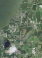 Aerial view of the University of Wisconsin–Green Bay and vicinity in Brown County 2020.png 9,340 × 12,754; 215.77 MB
-
-
 BironWisconsin2.jpg 2,304 × 1,398; 1.5 MB
-
 BironWisconsinSign.jpg 2,086 × 1,501; 1.47 MB
-
 Black River Falls Downtown Looking North WIS54.jpg 1,906 × 1,230; 895 KB
-
 Black River Falls Wisconsin Downtown2 WIS54.jpg 1,936 × 1,288; 1.03 MB
-
 BlackCreekWisconsinWisconsinWIS47WIS54.jpg 2,304 × 1,728; 819 KB
-
 BRF Downtown from church.jpg 2,032 × 1,524; 440 KB
-
 BuffaloCountyWisconsinSignWIS54.jpg 1,936 × 1,288; 1.36 MB
-
 Casco WI looking west WIS54.jpg 2,130 × 1,005; 1.13 MB
-

-
 GalesvilleWisconsinSignWIS54US53WIS93.jpg 1,936 × 1,288; 1.14 MB
-
 Hwy 187 & Hwy 54 Intersection Shioc.jpg 965 × 528; 53 KB
-
 Hwy 76 & Hwy 54 Intersection Shioc.jpg 909 × 514; 38 KB
-
 KewauneeCountyWisconsinWelcomeSignFarmingWIS54.jpg 1,936 × 1,288; 712 KB
-
 Liberty Outagamie County Wisconsin Sign.jpg 1,920 × 1,280; 928 KB
-
 LuxemburgWisconsinDowntown2.jpg 2,304 × 1,728; 746 KB
-
 MarshlandWisconsinDowntownWIS54WIS35GreatRiverRoad.jpg 1,936 × 1,288; 1.07 MB
-
 MarshlandWisconsinSignWIS54.jpg 1,936 × 1,288; 1.31 MB
-
 MelroseWisconsinDowntownWIS54.jpg 1,936 × 1,288; 1.09 MB
-
-
 NorthBendWisconsinSignWIS54.jpg 1,932 × 1,236; 1.02 MB
-
 Northport Waupaca County CDP Wisconsin Sign.jpg 1,752 × 1,184; 969 KB
-
 Northport Waupaca County Wisconsin looking west WIS54.jpg 1,920 × 1,280; 1.1 MB
-
 OneidaWisconsinSign.jpg 2,304 × 1,504; 523 KB
-
 OneidaWisconsinWIS54.jpg 2,304 × 1,728; 746 KB
-
 OneidaWisconsinWIS54b.jpg 2,304 × 1,453; 597 KB
-
 PortEdwardsWisconsinSign.jpg 2,304 × 1,728; 735 KB
-
 Royalton Wisconsin Downtown WIS54.jpg 1,920 × 1,180; 966 KB
-
 Royalton Wisconsin Sign WIS54.jpg 1,746 × 1,174; 919 KB
-
 SeymourWisconsin1.jpg 2,201 × 1,174; 370 KB
-
 ShioctonAirportOverviewWIS54.jpg 1,936 × 1,288; 767 KB
-
 US41WIS54.jpg 2,304 × 1,728; 762 KB
-
 WalhainWisconsinDowntownWIS54.jpg 1,936 × 1,218; 631 KB
-
 WalhainWisconsinSignWIS54.jpg 1,936 × 1,288; 685 KB
-
 WIS 54.svg 384 × 384; 2 KB
-
 Wis-54 & Wis-35 & US-53 junction Galesville.jpg 3,916 × 3,982; 10.75 MB
-
 Wis-54 & Wis-35 junction.jpg 4,000 × 3,000; 8.53 MB
-
 Wis-54 terminus with MN-43.jpg 4,000 × 3,000; 8.3 MB
-
 WIS172WestTerminus.jpg 2,304 × 1,728; 742 KB
-
 WIS172WestTerminus2.jpg 2,300 × 1,434; 632 KB
-
 WIS187SouthTerminusShioctonWisconsinWIS54.jpg 1,936 × 1,180; 1.09 MB
-
 WIS54EastTerminus.jpg 2,304 × 1,728; 838 KB
-
 Wisconsin State Highway 54 & 93.jpg 4,117 × 3,039; 8.02 MB
-
 WisconsinRapidsWisconsinDowntownWIS13WIS54.jpg 2,180 × 1,464; 1.59 MB
-
 WisconsinRiverWisconsinRapidsWIS54WIS13.jpg 2,304 × 1,728; 732 KB


Categories:
- State highways in Wisconsin by number
- Roads numbered 54
- Transport in Buffalo County, Wisconsin
- Transport in Trempealeau County, Wisconsin
- Transport in Jackson County, Wisconsin
- Transport in Wood County, Wisconsin
- Transport in Portage County, Wisconsin
- Transport in Waupaca County, Wisconsin
- Transport in Outagamie County, Wisconsin
- Transport in Brown County, Wisconsin
- Transport in Kewaunee County, Wisconsin