Category:Winter in Wiltshire
Jump to navigation
Jump to search
Ceremonial counties of England: Bedfordshire · Berkshire · Buckinghamshire · Cambridgeshire · Cheshire · Cornwall · Cumbria · Derbyshire · Devon · Dorset · Durham · East Riding of Yorkshire · East Sussex · Essex · Gloucestershire · Greater London · Greater Manchester · Hampshire · Herefordshire · Hertfordshire · Isle of Wight · Kent · Lancashire · Leicestershire · Lincolnshire · Merseyside · Norfolk · North Yorkshire · Northamptonshire · Northumberland · Nottinghamshire · Oxfordshire · Rutland · Shropshire · Somerset · South Yorkshire · Staffordshire · Suffolk · Surrey · Tyne and Wear · Warwickshire · West Sussex · West Yorkshire · Wiltshire · Worcestershire
City-counties: Bristol ·
Former historic counties:
Other former counties:
City-counties: Bristol ·
Former historic counties:
Other former counties:
Media in category "Winter in Wiltshire"
The following 66 files are in this category, out of 66 total.
-
 'Springfield Cottage' in Farley, Wiltshire, England.jpg 3,749 × 2,812; 11.48 MB
-
 Almshouses - Fox's Hospital - Farley, Wiltshire, England.jpg 4,040 × 2,273; 9.88 MB
-
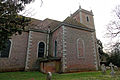 All Saints Church, Farley, Wiltshire, England from NE.jpg 4,608 × 3,072; 14.54 MB
-
 All Saints Church, Farley, Wiltshire, England from NW.jpg 4,555 × 3,415; 17.33 MB
-
 All Saints Church, Farley, Wiltshire, England from SE.jpg 4,460 × 2,973; 13.35 MB
-
 All Saints Church, Farley, Wiltshire, England from SW.jpg 4,608 × 3,072; 12.94 MB
-
 Allotments, Hindon - geograph.org.uk - 1704764.jpg 640 × 480; 84 KB
-
 Apartments by the River Avon - geograph.org.uk - 137901.jpg 640 × 480; 99 KB
-
 Bales block the gap, Croucheston - geograph.org.uk - 1653338.jpg 640 × 480; 164 KB
-
 Barn conversion in Farley, Wiltshire, England.jpg 4,608 × 2,304; 8.5 MB
-
 Barn, house and road junction, Farley, Wiltshire, England.jpg 4,608 × 3,072; 16.61 MB
-
 Beech hedge. Ferne - geograph.org.uk - 1154021.jpg 480 × 640; 176 KB
-
 Beech trees, Throope Bottom - geograph.org.uk - 1651539.jpg 640 × 481; 170 KB
-
 Been sledgin', Bishopstone - geograph.org.uk - 1655636.jpg 640 × 481; 116 KB
-
 St John the Baptist Church, Bishopstone - geograph.org.uk - 1144981.jpg 640 × 480; 135 KB
-
 Bishopstone Hollow - geograph.org.uk - 1653526.jpg 640 × 480; 215 KB
-
 Bishopstone Meadow - geograph.org.uk - 1655986.jpg 640 × 480; 150 KB
-
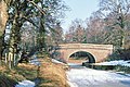 Bristow Bridge - geograph.org.uk - 1170882.jpg 640 × 426; 113 KB
-
 Canal bridge and parapet, East Grimstead, Wiltshire, England.jpg 4,608 × 3,456; 16.98 MB
-
 Canal bridge east parapet, East Grimstead, Wiltshire, England.jpg 4,608 × 3,456; 18.01 MB
-
 Canal bridge west parapet, East Grimstead, Wiltshire, England.jpg 4,608 × 3,456; 20.57 MB
-
 Charlton all saints.JPG 3,488 × 2,616; 4.38 MB
-
 Church of the Holy Trinity - sign board - East Grimstead, Wiltshire, England.jpg 3,827 × 3,062; 12.12 MB
-
 Church of the Holy Trinity porch and nave, East Grimstead, Wiltshire, England.jpg 4,320 × 3,456; 14.66 MB
-
 Church of the Holy Trinity, East Grimstead, Wiltshire, England from NW.jpg 4,254 × 3,328; 13.81 MB
-
 Church of the Holy Trinity, East Grimstead, Wiltshire, England, from NE.jpg 3,456 × 3,456; 12.48 MB
-
 Church of the Holy Trinity, East Grimstead, Wiltshire, England, from NW.jpg 3,347 × 3,347; 12.59 MB
-
 Church of the Holy Trinity, East Grimstead, Wiltshire, England, from SE.jpg 4,103 × 3,058; 12.13 MB
-
 Church of the Holy Trinity, East Grimstead, Wiltshire, England, from SW.jpg 3,066 × 3,066; 11.57 MB
-
 All Saints Church tower, Farley, Wiltshire, England from the west.jpg 3,160 × 4,214; 15.24 MB
-
 Faulston Farm - geograph.org.uk - 1651312.jpg 640 × 480; 155 KB
-
 Faultston Lane, Bishopstone - geograph.org.uk - 1650689.jpg 640 × 480; 174 KB
-
 Field roller - geograph.org.uk - 1079341.jpg 640 × 452; 193 KB
-
 Great Durnford church in snow.jpg 1,603 × 1,073; 270 KB
-
 Ha'penny Bridge in winter - geograph.org.uk - 333653.jpg 640 × 480; 107 KB
-
 Happy Lichen - geograph.org.uk - 350611.jpg 480 × 640; 122 KB
-
 Heytesbury, Wiltshire - geograph.org.uk - 65241.jpg 640 × 480; 87 KB
-
 Highworth cemetery at the winter solstice - geograph.org.uk - 638069.jpg 640 × 480; 103 KB
-
 Hoar frost, Harewarren - geograph.org.uk - 1116235.jpg 480 × 640; 177 KB
-

-
 Iced teasels, Bishopstone - geograph.org.uk - 1630610.jpg 480 × 640; 158 KB
-
 Keevil Wick Farm in winter - geograph.org.uk - 1073222.jpg 640 × 515; 155 KB
-
 Kennet and Avon Canal in the big freeze - geograph.org.uk - 1170869.jpg 640 × 419; 126 KB
-
 Leywood Bridge in Winter - geograph.org.uk - 690282.jpg 480 × 640; 135 KB
-
 Liden Lagoon, Swindon (6) - geograph.org.uk - 1148958.jpg 479 × 640; 173 KB
-

-
 Mill Lane, Swindon, in winter - geograph.org.uk - 1480989.jpg 640 × 430; 111 KB
-

-
-

-
 Sheep, Throope Down - geograph.org.uk - 1651512.jpg 640 × 481; 199 KB
-
 Stonehenge Winter Solstice 2011.jpg 3,072 × 2,304; 1.34 MB
-

-

-
 The Lamb Inn, Hindon - geograph.org.uk - 1704797.jpg 640 × 480; 111 KB
-
 Tractor Tracks and Winter Feed - geograph.org.uk - 298096.jpg 640 × 480; 89 KB
-
 View down the High Street, Hindon - geograph.org.uk - 1704811.jpg 640 × 480; 75 KB
-

-

-
 St Marys (Old Church) Wilton - geograph.org.uk - 1145300.jpg 640 × 480; 163 KB
-
 Winter at Heaven's Gate - geograph.org.uk - 1121255.jpg 640 × 480; 98 KB
-

-
 Winter Feed - geograph.org.uk - 301121.jpg 640 × 480; 127 KB
-
 Winter Quarters - geograph.org.uk - 129537.jpg 640 × 480; 73 KB
-
 Winter sunset, Avebury henge - geograph.org.uk - 1098514.jpg 427 × 640; 107 KB
-
 Wood pigeons, near Wanborough - geograph.org.uk - 1144382.jpg 640 × 480; 175 KB


_-_geograph.org.uk_-_1148958.jpg)


_Wilton_-_geograph.org.uk_-_1145300.jpg)


