Category:Willington, Derbyshire
Jump to navigation
Jump to search

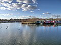
English: Willington is a village in the district of South Derbyshire, in the East Midlands region of England. The village's population is approximately 2700 (2007).
village and civil parish in South Derbyshire district, Derbyshire, England  | |||||
| Upload media | |||||
| Instance of | |||||
|---|---|---|---|---|---|
| Location | South Derbyshire, Derbyshire, East Midlands, England | ||||
| Said to be the same as | Willington (Wikimedia duplicated page, civil parish) | ||||
| official website | |||||
 | |||||
Subcategories
This category has the following 8 subcategories, out of 8 total.
B
- Blue Bus of Willington (1 F)
D
- Derby with Burton Services (5 F)
M
T
W
- Willington Bridge (7 F)
- Willington Power Station (30 F)
- Willington railway station (5 F)
Media in category "Willington, Derbyshire"
The following 200 files are in this category, out of 281 total.
(previous page) (next page)-
 'Just because we can' - geograph.org.uk - 3182165.jpg 3,264 × 2,448; 4.03 MB
-
 'OK' Diner by to the A38 Road - geograph.org.uk - 2877192.jpg 3,072 × 2,150; 1.06 MB
-
 2021-04-10 Mercia Marina, Trent and Mersey Canal, Willington, Derbyshire (1).jpg 3,000 × 2,000; 4.2 MB
-
 2021-04-10 Mercia Marina, Trent and Mersey Canal, Willington, Derbyshire.jpg 3,000 × 2,000; 4.67 MB
-
 A distant view of Willington - geograph.org.uk - 5680470.jpg 2,000 × 1,333; 1.76 MB
-
 A train to Derby - geograph.org.uk - 3939617.jpg 1,200 × 900; 228 KB
-

-
 A38 Crossing the A50 at Junction 4 - geograph.org.uk - 4239232.jpg 640 × 480; 258 KB
-
 A38 north of Willington crossroads - geograph.org.uk - 2396128.jpg 640 × 480; 49 KB
-
 A50 at the A38 junction - geograph.org.uk - 2340205.jpg 640 × 480; 58 KB
-
 A50 Junction 4 - geograph.org.uk - 4239228.jpg 640 × 480; 238 KB
-
 A50 passing under the A38 - geograph.org.uk - 3413403.jpg 640 × 428; 42 KB
-
 A5132 heading east - geograph.org.uk - 3424074.jpg 640 × 480; 61 KB
-
 A5132 heading east - geograph.org.uk - 3424113.jpg 640 × 480; 44 KB
-
 Across the A38 - geograph.org.uk - 5019382.jpg 1,600 × 1,199; 257 KB
-

-
 At Mercia Marina - geograph.org.uk - 4538271.jpg 1,024 × 731; 913 KB
-
 Bargare Lane in Willington, Derbyshire - geograph.org.uk - 5597275.jpg 1,280 × 828; 1.33 MB
-
 Barns near Willington - geograph.org.uk - 3580012.jpg 1,280 × 960; 291 KB
-
 Birmingham train rushing by - geograph.org.uk - 1924797.jpg 640 × 427; 98 KB
-
 Blue boat under blue skies - geograph.org.uk - 1922116.jpg 640 × 427; 100 KB
-
 Bridge 15BB - geograph.org.uk - 3356838.jpg 1,200 × 900; 236 KB
-
-
 Bridges at the A50-A38 junction - geograph.org.uk - 2340218.jpg 640 × 480; 64 KB
-
 Broadbeam canal trip boat at Willington, Derbyshire - geograph.org.uk - 5050424.jpg 1,595 × 1,080; 2.01 MB
-
 Buckford Bridge - geograph.org.uk - 5131657.jpg 800 × 600; 103 KB
-
 By Willington Power station - geograph.org.uk - 5483927.jpg 2,000 × 1,333; 1.43 MB
-
 Canal at Willington in Derbyshire - geograph.org.uk - 5565016.jpg 1,518 × 1,080; 2.41 MB
-
 Canal milepost at Willington - geograph.org.uk - 3182184.jpg 3,264 × 2,448; 5.83 MB
-
 Canal milepost at Willington - geograph.org.uk - 3580003.jpg 960 × 1,280; 486 KB
-
 Canal milepost commemorative plaque - geograph.org.uk - 3580005.jpg 1,280 × 960; 580 KB
-
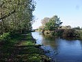
 Canal north of Willington - geograph.org.uk - 3961154.jpg 1,600 × 1,200; 435 KB
-
 Canal-side industry - geograph.org.uk - 1924646.jpg 640 × 427; 116 KB
-

-
 Centre of Willington - geograph.org.uk - 1924765.jpg 640 × 427; 79 KB
-
 Cherry Tree Farm - geograph.org.uk - 2781765.jpg 1,200 × 900; 142 KB
-
 Church of St Michael, Willington - geograph.org.uk - 3216503.jpg 3,620 × 2,714; 1.88 MB
-
 Class 37 558 "Avro Vulcan XH558" North Staffs jn.jpg 5,101 × 2,960; 18.3 MB
-
 Cooling tower near Willington - geograph.org.uk - 3580038.jpg 853 × 1,280; 151 KB
-

-
 Cooling Towers at Willington - geograph.org.uk - 4292598.jpg 4,000 × 3,000; 2.61 MB
-
 Cooling Towers at Willington - geograph.org.uk - 5394165.jpg 640 × 480; 344 KB
-
 Cooling towers, former Willington power station - geograph.org.uk - 3424105.jpg 900 × 1,200; 289 KB
-
-
 Cornfield and cooling towers - geograph.org.uk - 3580008.jpg 1,280 × 949; 428 KB
-
 Could this be Eeyore^ DSCN2958 - Flickr - ianpreston.jpg 4,608 × 3,456; 6.25 MB
-
 Dead tree by the Trent and Mersey Canal - geograph.org.uk - 3993413.jpg 2,048 × 1,360; 658 KB
-
 Defunct cooling towers - geograph.org.uk - 5483924.jpg 2,000 × 1,333; 1.39 MB
-
 Derby ^ Burton Services - geograph.org.uk - 5116770.jpg 800 × 457; 65 KB
-
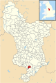 Derbyshire UK parish map highlighting Willington.svg 888 × 1,308; 2.35 MB
-
 Disused cooling towers - geograph.org.uk - 4900209.jpg 3,264 × 2,448; 2.52 MB
-
 Disused power station, Willington - geograph.org.uk - 4149783.jpg 592 × 640; 187 KB
-
 Drain culvert under the canal - geograph.org.uk - 3356828.jpg 1,200 × 900; 383 KB
-
 Early morning sun on Mercia Marina - geograph.org.uk - 5892526.jpg 5,013 × 3,342; 3.06 MB
-
 Entrance to Mercia Marina - geograph.org.uk - 3961161.jpg 1,600 × 1,200; 578 KB
-
 Entrance to the Mercia Marina - geograph.org.uk - 4618376.jpg 800 × 586; 146 KB
-
 Etwall Road - geograph.org.uk - 3580014.jpg 1,280 × 960; 522 KB
-
 Etwall Road level crossing - geograph.org.uk - 3580009.jpg 1,280 × 960; 365 KB
-
 Etwall Road level crossing - geograph.org.uk - 3580016.jpg 1,280 × 960; 324 KB
-
 Etwall Road, Willington - geograph.org.uk - 4864133.jpg 3,264 × 2,448; 4.73 MB
-
 Farmland near Willington - geograph.org.uk - 3745050.jpg 4,000 × 3,000; 2.03 MB
-
 Farmland west of Willington - geograph.org.uk - 3424072.jpg 640 × 480; 48 KB
-
 Fence by Twyford Road - geograph.org.uk - 4900219.jpg 3,264 × 2,448; 4.7 MB
-
 Field by Trent ^ Mersey Canal, Willington - geograph.org.uk - 5359782.jpg 1,024 × 768; 116 KB
-
 Field north of Willington - geograph.org.uk - 4864161.jpg 3,264 × 2,448; 4.16 MB
-
 Field of Sheep near the A38 Road - geograph.org.uk - 3745069.jpg 4,000 × 3,000; 1.68 MB
-
 Flood Plain of the River Trent - geograph.org.uk - 5311126.jpg 2,000 × 1,333; 1.48 MB
-
 Footbridge - geograph.org.uk - 258577.jpg 640 × 426; 114 KB
-
 Footbridge over the Burton to Derby railway line - geograph.org.uk - 3216556.jpg 3,299 × 2,565; 2.02 MB
-
 Footpath alongside the Burton to Derby railway line - geograph.org.uk - 3216541.jpg 4,000 × 3,000; 4.77 MB
-
 Footpath by the railway to Willington at sunset - geograph.org.uk - 4331819.jpg 1,200 × 900; 236 KB
-
 Footpath crossing railway north of Willington, Derbyshire - geograph.org.uk - 5050578.jpg 1,440 × 1,080; 1.76 MB
-
 Footpath level crossing - geograph.org.uk - 3939611.jpg 1,200 × 900; 220 KB
-
 Footpath round the west side of Willington - geograph.org.uk - 3216533.jpg 4,000 × 3,000; 4.59 MB
-
 Footpath to the ford - geograph.org.uk - 1888709.jpg 480 × 640; 192 KB
-
 Footpath to Willington , beside the railway - geograph.org.uk - 3960565.jpg 1,600 × 1,200; 521 KB
-
 Footpath towards Etwall - geograph.org.uk - 3580019.jpg 1,280 × 960; 302 KB
-
 Footpath, Meadow Lane - geograph.org.uk - 252265.jpg 461 × 640; 171 KB
-
 Ford on the River Trent at Ferry Meadow - geograph.org.uk - 1890234.jpg 480 × 640; 180 KB
-
 Former transshipment basin - geograph.org.uk - 3356817.jpg 1,200 × 900; 250 KB
-
 Fuel Filling Station - A38 - geograph.org.uk - 3880728.jpg 3,966 × 1,920; 3.29 MB
-
 Grazing, Potlocks House Farm - geograph.org.uk - 3424108.jpg 640 × 480; 51 KB
-
 Green Plantation - geograph.org.uk - 3356822.jpg 1,200 × 900; 215 KB
-
 Gull at Mercia Marina - geograph.org.uk - 4846955.jpg 640 × 480; 210 KB
-
 Hanson's Reach Marketing Suite - geograph.org.uk - 3960575.jpg 1,600 × 1,200; 461 KB
-
 Hill Farm, near Willington - geograph.org.uk - 380556.jpg 640 × 480; 84 KB
-
 Hotel off the A38, near Willington - geograph.org.uk - 2262009.jpg 640 × 480; 43 KB
-
 Houses on the Castle Way, Willington - geograph.org.uk - 1924752.jpg 640 × 427; 87 KB
-
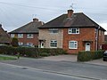 Houses on Twyford Road, Willington - geograph.org.uk - 3424081.jpg 640 × 480; 63 KB
-
 Lane Markings - geograph.org.uk - 707864.jpg 427 × 640; 207 KB
-
 Level Crossing - geograph.org.uk - 273600.jpg 640 × 426; 99 KB
-
 Level Crossing Willington - geograph.org.uk - 1065836.jpg 640 × 480; 64 KB
-
 Looking down on the A50 - geograph.org.uk - 707726.jpg 640 × 427; 246 KB
-

-
 Looking towards Repton - geograph.org.uk - 5311128.jpg 2,000 × 1,333; 1.51 MB
-

-
 Low Bridge - geograph.org.uk - 3580030.jpg 1,280 × 960; 303 KB
-
 Melting frost - geograph.org.uk - 707837.jpg 427 × 640; 217 KB
-
 Mercia Marina - geograph.org.uk - 4846957.jpg 640 × 481; 367 KB
-
 Mercia Marina - geograph.org.uk - 5444892.jpg 2,000 × 1,333; 1.81 MB
-
 Mercia Marina - geograph.org.uk - 5444897.jpg 2,000 × 1,333; 1.51 MB
-
 Mercia Marina at night - geograph.org.uk - 5260434.jpg 1,600 × 1,067; 436 KB
-

-

-
 Mercia Marina, Willington - geograph.org.uk - 4846947.jpg 640 × 481; 487 KB
-
 Moored narrowboat at Willington in Derbyshire - geograph.org.uk - 5050646.jpg 1,280 × 960; 1,013 KB
-
 Moorings at Mercia Marina - geograph.org.uk - 4539405.jpg 1,024 × 731; 877 KB
-
 Moorings at Willington - geograph.org.uk - 3960579.jpg 1,600 × 1,200; 400 KB
-
 Moorings at Willington in Derbyshire - geograph.org.uk - 5596978.jpg 1,280 × 860; 899 KB
-
 Moorings at Willington in Derbyshire - geograph.org.uk - 5596979.jpg 1,280 × 844; 1.14 MB
-
 Moorings at Willington in Derbyshire - geograph.org.uk - 5596983.jpg 1,280 × 960; 1.26 MB
-
 More fields - geograph.org.uk - 5445926.jpg 2,000 × 1,333; 2.04 MB
-
 Narrowboat on the Trent ^ Mersey Canal - geograph.org.uk - 4620616.jpg 800 × 554; 124 KB
-
 Narrowboats - geograph.org.uk - 5892525.jpg 5,472 × 3,648; 6.93 MB
-
 On the Trent and Mersey Canal - geograph.org.uk - 1924562.jpg 640 × 427; 131 KB
-
 Only the towers are left - geograph.org.uk - 6205868.jpg 2,000 × 1,330; 1.43 MB
-
 Overbridge at A50 junction - geograph.org.uk - 4569479.jpg 640 × 352; 45 KB
-
 Petrol station on the A38 - geograph.org.uk - 2920763.jpg 1,024 × 768; 149 KB
-
 Playing Fields - geograph.org.uk - 258558.jpg 640 × 426; 79 KB
-
 Plenty of moorings at Willington - geograph.org.uk - 1924624.jpg 640 × 427; 105 KB
-
 Police car - geograph.org.uk - 5665897.jpg 3,562 × 2,438; 1.11 MB
-

-

-
 Rail bridge over the Trent ^ Mersey Canal - geograph.org.uk - 4864185.jpg 3,264 × 2,448; 4.87 MB
-
 Burton, Dove, Egginton & Willington RJD 22.jpg 1,888 × 2,861; 877 KB
-

-
 Railway bridge at Willington, Derbyshire - geograph.org.uk - 1607643.jpg 640 × 470; 133 KB
-

-
 Railway from the footbridge southwest of Willington - geograph.org.uk - 3960561.jpg 1,600 × 1,200; 370 KB
-
 Railway line north of Willington, Derbyshire - geograph.org.uk - 5050536.jpg 1,280 × 825; 856 KB
-
 Railway line north of Willington, Derbyshire - geograph.org.uk - 5050556.jpg 1,280 × 765; 751 KB
-
 Railway near Willington - geograph.org.uk - 3200802.jpg 640 × 443; 86 KB
-
 Railway north of Willington, Derbyshire - geograph.org.uk - 5050565.jpg 1,280 × 960; 757 KB
-
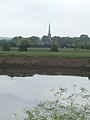
 Repton and the River Trent - geograph.org.uk - 3558522.jpg 3,264 × 2,448; 3.36 MB
-
 Repton Road (B5008), Willington - geograph.org.uk - 3216510.jpg 3,785 × 2,820; 2.28 MB
-
 Returning the empties - geograph.org.uk - 3968893.jpg 1,200 × 900; 213 KB
-
 River Trent from Willington Bridge.jpg 3,072 × 2,304; 2.59 MB
-
 River Trent near Willington - geograph.org.uk - 380263.jpg 640 × 480; 89 KB
-
 Roadside cedar - geograph.org.uk - 380548.jpg 640 × 480; 100 KB
-
 Roundabout over the A50 - geograph.org.uk - 707819.jpg 640 × 427; 134 KB
-
 Rumenco Farm - geograph.org.uk - 3939644.jpg 1,200 × 900; 179 KB
-
 Service stop, A38, south of the A50 junction - geograph.org.uk - 5019392.jpg 1,600 × 1,134; 279 KB
-
 Shops at Willington - geograph.org.uk - 4779385.jpg 3,264 × 2,448; 4.1 MB
-
 Sign at the Green Dragon - geograph.org.uk - 1924784.jpg 547 × 640; 145 KB
-
 Signage and road junction - geograph.org.uk - 5665885.jpg 4,690 × 3,647; 1.7 MB
-
 St Michael's Church, Willington - geograph.org.uk - 2770691.jpg 800 × 600; 96 KB
-
 St Michael's Church, Willington - geograph.org.uk - 3960571.jpg 1,600 × 1,200; 575 KB
-
 St Michael's Church, Willington - geograph.org.uk - 5115189.jpg 800 × 600; 154 KB
-
 St. Michael's Church Willington - geograph.org.uk - 5311124.jpg 2,000 × 1,283; 2.19 MB
-
 Stairs to the Roundabout on the Derby Nomad Way - geograph.org.uk - 3939632.jpg 900 × 1,200; 339 KB
-

-
 Stile on a footpath to Willington - geograph.org.uk - 3968880.jpg 1,200 × 900; 272 KB
-
 Stile on the Derby Nomad Way at Rumenco Farm - geograph.org.uk - 3939651.jpg 1,200 × 900; 332 KB
-
 Stiles on the Airport Way - geograph.org.uk - 3939662.jpg 1,200 × 900; 390 KB
-
 Stubble field and bales at Willington - geograph.org.uk - 4864176.jpg 3,264 × 2,448; 4.98 MB
-
 The A38 - geograph.org.uk - 5465513.jpg 2,000 × 1,333; 2.12 MB
-
 The A38 crosses the A50 - geograph.org.uk - 2920497.jpg 4,000 × 3,000; 4.06 MB
-
 The A38 towards Burton - geograph.org.uk - 5465519.jpg 2,000 × 1,333; 2.09 MB
-
 The B5008 - geograph.org.uk - 5444890.jpg 2,000 × 1,333; 2.76 MB
-
 The Boardwalk, Mercia Marina - geograph.org.uk - 4846961.jpg 640 × 481; 508 KB
-
 The Boat Inn - geograph.org.uk - 1928183.jpg 1,200 × 900; 244 KB
-
 The Castle Way (A5132), Willington - geograph.org.uk - 3424080.jpg 640 × 480; 55 KB
-

-
 The Castle Way, Willington - geograph.org.uk - 1924721.jpg 640 × 427; 86 KB
-
 The Dragon - geograph.org.uk - 2847148.jpg 1,200 × 900; 148 KB
-
 The entrance to Mercia Marina - geograph.org.uk - 5115193.jpg 800 × 496; 110 KB
-
 The Green Dragon, Willington - geograph.org.uk - 1924777.jpg 640 × 543; 111 KB
-
 The Green Man - geograph.org.uk - 5665893.jpg 6,000 × 4,000; 2.46 MB
-
 The Lobby Emporium - geograph.org.uk - 3580027.jpg 1,280 × 1,280; 377 KB
-
 The new Co-op - geograph.org.uk - 4333248.jpg 1,200 × 900; 188 KB
-
 The outskirts of Willington - geograph.org.uk - 5444874.jpg 2,000 × 1,333; 2.13 MB
-

-
 The railway at Willington - geograph.org.uk - 5284769.jpg 1,067 × 1,600; 405 KB
-
 The remains of Willington Power Station - geograph.org.uk - 5284764.jpg 1,600 × 1,067; 400 KB
-
 The Rising Sun - geograph.org.uk - 3580022.jpg 1,280 × 960; 181 KB
-
 The Rising Sun - geograph.org.uk - 5665890.jpg 6,000 × 4,000; 1.65 MB
-
 The Rising Sun at Willington - geograph.org.uk - 3182092.jpg 3,264 × 2,448; 3.51 MB
-
 The Rising Sun goes Thai - geograph.org.uk - 3677359.jpg 1,200 × 900; 136 KB
-
 The River Trent at Willington Bridge, Derbyshire - geograph.org.uk - 5597289.jpg 1,280 × 940; 1.01 MB
-
 The River Trent from Willington Bridge - geograph.org.uk - 3878624.jpg 3,878 × 2,830; 1.34 MB
-

-

-

-

-

-
 The Trent and Mersey Canal at Willington - geograph.org.uk - 3878528.jpg 3,808 × 2,724; 1.57 MB
-
 The Trent and Mersey Canal west of Willington - geograph.org.uk - 3216564.jpg 4,000 × 3,000; 4.82 MB
-
 The Trent ^ Mersey Canal - geograph.org.uk - 5101947.jpg 640 × 480; 38 KB
-
 The Trent ^ Mersey Canal at Willington - geograph.org.uk - 5110763.jpg 800 × 600; 172 KB
-
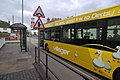 The Villager at Willington - geograph.org.uk - 1542697.jpg 640 × 428; 70 KB
-
 This is South Derbyshire.jpg 3,008 × 1,200; 2.37 MB
-
 This way to Willington - geograph.org.uk - 3968876.jpg 1,200 × 900; 176 KB
-
 Through the yellow stuff - geograph.org.uk - 3939602.jpg 1,200 × 900; 231 KB
-
 Tight bridge over Twyford Road - geograph.org.uk - 680694.jpg 640 × 477; 88 KB
-
 Train next to the Trent ^ Mersey Canal - geograph.org.uk - 4618182.jpg 800 × 564; 166 KB
-
 Trent and Mersey Canal at Willington in Derbyshire - geograph.org.uk - 5050429.jpg 1,440 × 977; 1.67 MB
-
 Trent and Mersey Canal at Willington in Derbyshire - geograph.org.uk - 5564994.jpg 1,600 × 1,200; 1.89 MB
-

-

-


.jpg)


,_Willington_-_geograph.org.uk_-_3216510.jpg)


,_Willington_-_geograph.org.uk_-_3424080.jpg)


