Category:Welzow
Jump to navigation
Jump to search
town in Brandenburg state, Germany     | |||||
| Upload media | |||||
| Instance of |
| ||||
|---|---|---|---|---|---|
| Part of |
| ||||
| Location | Spree-Neiße District, Brandenburg, Germany | ||||
| Street address |
| ||||
| Population |
| ||||
| Area |
| ||||
| Elevation above sea level |
| ||||
| official website | |||||
 | |||||
Subcategories
This category has the following 10 subcategories, out of 10 total.
Media in category "Welzow"
The following 35 files are in this category, out of 35 total.
-
De-Welzow.ogg 1.8 s; 18 KB
-
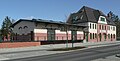
 29601-Welzow-1959-Bahnhof-Brück & Sohn Kunstverlag.jpg 1,528 × 1,000; 453 KB
-
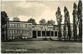 29602-Welzow-1959-Puschkinschule-Brück & Sohn Kunstverlag.jpg 1,536 × 1,000; 444 KB
-
 29603-Welzow-1959-An der Aue-Brück & Sohn Kunstverlag.jpg 1,534 × 1,000; 481 KB
-
 AG Eintracht Braunkohlenwerke und Briketfabriken 1905.jpg 2,985 × 2,109; 969 KB
-
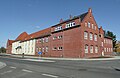
 Alte Dorfschule Welzow.jpg 2,816 × 2,112; 2.19 MB
-
 Bahnhof Welzow.jpg 2,816 × 1,434; 1.65 MB
-
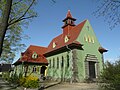
 Casino der Eintracht AG Welzow.jpg 3,232 × 2,608; 1.28 MB
-
 Ehemalige Kleinkinderschule Welzow.jpg 2,703 × 2,112; 2.11 MB
-
 Ehrenmal für Opfer des Faschismus Welzow.jpg 2,112 × 2,816; 2.15 MB
-
 Feuerwehrdepot Welzow.jpg 2,816 × 2,112; 2.7 MB
-
 Field near Haidemühl 2019-06-05 01.jpg 5,184 × 3,888; 9.87 MB
-
 Field near Haidemühl 2019-06-05 02.jpg 5,184 × 3,888; 10.64 MB
-
 Field near Haidemühl 2019-06-05 03.jpg 5,184 × 3,888; 9.41 MB
-
 Field near Haidemühl 2019-06-05 04.jpg 5,184 × 3,888; 10.53 MB
-
 Field near Haidemühl 2019-06-05 05.jpg 5,184 × 3,888; 10.05 MB
-
 Field near Haidemühl 2019-06-05 06.jpg 5,184 × 3,888; 9.66 MB
-
 Field near Haidemühl 2019-06-05 07.jpg 5,184 × 3,888; 10.01 MB
-
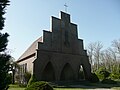
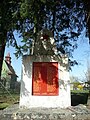
 Friedhofskapelle Jahnstraße Welzow.jpg 2,816 × 2,112; 2.35 MB
-
 Friedhofskapelle Liesker Weg Welzow.jpg 2,816 × 2,112; 2.25 MB
-
 Hotel Rathsburg Welzow.jpg 2,547 × 2,890; 702 KB
-
 Johann Wolfgang von Goethe Grundschule Welzow.jpg 3,192 × 2,082; 827 KB
-
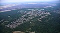 KLG 0169 Welzow.jpg 6,016 × 3,384; 8.42 MB
-
 Kumpelklause, Spremberger Straße 77, Welzow.jpg 3,264 × 2,448; 2.56 MB
-
 L522 Welzow 2019-06-05 01.jpg 5,184 × 3,888; 9.67 MB
-
 L522 Welzow 2019-06-05 02.jpg 5,184 × 3,888; 10.1 MB
-
 Proschim Widerstand gegen Abbagerung (1).JPG 3,072 × 2,304; 2.93 MB
-
 Puschkin Schule Welzow.jpg 2,816 × 2,112; 2.27 MB
-
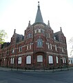
 Rathaus Welzow.jpg 2,816 × 2,112; 2.33 MB
-
 Sowjetischer Ehrenfriedhof Welzow.jpg 2,112 × 2,816; 2.42 MB
-
 Verwaltungsgebaeude Eintracht AG Welzow.jpg 2,816 × 2,112; 2.58 MB
-
 Welzow - ehemaliges Hotel Rathsburg, Brandenburg, 2021.jpg 5,096 × 3,590; 14.26 MB
-
 Welzow in SPN.png 299 × 299; 8 KB
-
 Welzow Sowjetischer Ehrenfriedhof.jpg 2,112 × 2,816; 2.15 MB
-
 Wohnhaeuser Beethovenstrasse Welzow.jpg 2,786 × 2,092; 2.28 MB


.JPG)


