Category:Watertower Geesthacht
Jump to navigation
Jump to search
| Object location | | View all coordinates using: OpenStreetMap |
|---|
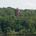
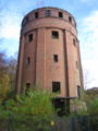
former water tower in Geesthacht, Germany  | |||||
| Upload media | |||||
| Instance of | |||||
|---|---|---|---|---|---|
| Part of | |||||
| Location | Krümmel, Geesthacht, Herzogtum Lauenburg, Schleswig-Holstein, Germany | ||||
| Street address |
| ||||
| Owned by | |||||
| Heritage designation | |||||
 | |||||
The pictures of this category show a cultural heritage monument according to the Cultural Heritage Protection Law of Schleswig-Holstein with the ID 10009
|
Media in category "Watertower Geesthacht"
The following 8 files are in this category, out of 8 total.
-
 21502 Geesthacht, Germany - panoramio.jpg 1,552 × 2,592; 882 KB
-
 Dynamitfabrik kruemmel wasserturm 01.jpg 640 × 640; 97 KB
-
 Dynamitfabrik kruemmel wasserturm 02.jpg 1,296 × 972; 415 KB
-
 FIMG-logo-wasserturm XM.gif 270 × 500; 41 KB
-
 Krümmel Wasserturm.jpg 788 × 1,050; 160 KB
-
 Lce6.jpg 2,272 × 1,712; 1.93 MB
-
 Lce9.jpg 2,272 × 1,712; 1.84 MB
-
 Wasserturm Dyna.jpg 576 × 768; 109 KB


Categories:
- Dynamitfabrik Krümmel
- Cultural heritage monuments in Geesthacht
- Water towers in Schleswig-Holstein
- Ruins in Schleswig-Holstein
- Former water towers
- Concrete towers in Schleswig-Holstein
- Brick towers in Schleswig-Holstein
- Red brick buildings in Germany
- Round towers in Schleswig-Holstein
- Built in Schleswig-Holstein in 1917
- 30-meter-tall buildings in Germany