Category:Waterpoort Boerenboom, Enkhuizen
Jump to navigation
Jump to search
| Object location | | View all coordinates using: OpenStreetMap |
|---|
 | |||||
| Upload media | |||||
| Instance of | |||||
|---|---|---|---|---|---|
| Part of | |||||
| Location | Enkhuizen, North Holland, Netherlands | ||||
| Street address |
| ||||
| Heritage designation |
| ||||
 | |||||
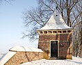
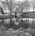
English: The Boerenboom, a water gate in the Dutch town of Enkhuizen
Nederlands: De Boerenboom, een waterpoort in de Nederlandse plaats Enkhuizen die uitkomt op de Noorder Boerenvaart
|
This is a category about rijksmonument number 464871
|
| Address |
|
Media in category "Waterpoort Boerenboom, Enkhuizen"
The following 9 files are in this category, out of 9 total.
-
 20100613 Boerenboom Enkhuizen Stadszijde.jpg 3,264 × 2,448; 2.79 MB
-
 20100613 Boerenboom Enkhuizen.jpg 3,264 × 2,448; 2.66 MB
-
 Boereboom - Enkhuizen - 20071197 - RCE.jpg 1,200 × 952; 247 KB
-
 Boerenboom b.4 - Enkhuizen - 20070243 - RCE.jpg 958 × 1,200; 203 KB
-
 Boerenboom.jpg 3,498 × 2,784; 3.15 MB
-
 De Boerenboom, Enkhuizen.JPG 960 × 1,280; 259 KB
-

-
 Vesting, Boereboom - Enkhuizen - 20070051 - RCE.jpg 1,190 × 1,200; 455 KB
-
 Waterpoorthuisje Boerenboom Enkhuizen.jpg 3,672 × 4,896; 2.51 MB


