Category:Walfriduskerk
Jump to navigation
Jump to search
| Object location | | View all coordinates using: OpenStreetMap |
|---|
church in Bedum, Netherlands  | |||||
| Upload media | |||||
| Instance of | |||||
|---|---|---|---|---|---|
| Named after |
| ||||
| Location | Bedum, Het Hogeland, Groningen, Netherlands | ||||
| Street address |
| ||||
| Located on street |
| ||||
| Architectural style | |||||
| Has part(s) |
| ||||
| Heritage designation |
| ||||
| Angle from vertical |
| ||||
| official website | |||||
 | |||||
Nederlands: Walfriduskerk
|
This is a category about rijksmonument number 8728
|
| Address |
|
Media in category "Walfriduskerk"
The following 200 files are in this category, out of 266 total.
(previous page) (next page)-
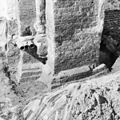
 Aangebouwde steunberen, toren - Bedum - 20028670 - RCE.jpg 874 × 1,200; 298 KB
-
 Bedum - Walfriduskerk - schuin van achteren.jpg 3,736 × 2,802; 4.66 MB
-
 Bedum - Walfriduskerk - verbodsbordje.jpg 3,916 × 2,937; 4.16 MB
-
 Bedum - Walfriduskerk - voor links.jpg 4,000 × 3,000; 5.01 MB
-
 Bedum - Walfriduskerk - voor rechts.jpg 4,000 × 3,000; 8.5 MB
-
 Bedum - Walfriduskerk over Boterdiep.jpg 3,868 × 2,901; 3.41 MB
-
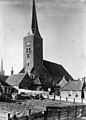
 Bedum Walfriduskerk.jpg 700 × 933; 315 KB
-
 Bouwsporen aan de noordkant van de noordwestgevel - Bedum - 20400591 - RCE.jpg 1,200 × 1,192; 436 KB
-
 Bouwsporen aan de westhoek van de kerk - Bedum - 20400593 - RCE.jpg 1,200 × 1,195; 369 KB
-
 Bovengedeelte van het raam in de zuidgevel boven de ingang - Bedum - 20400625 - RCE.jpg 1,200 × 1,200; 407 KB
-
 Deel van de oostgevel - Bedum - 20400607 - RCE.jpg 1,197 × 1,200; 461 KB
-
 Detail van de oostgevel - Bedum - 20400608 - RCE.jpg 1,195 × 1,200; 463 KB
-
 Detail van de oostgevel - Bedum - 20400609 - RCE.jpg 1,195 × 1,200; 482 KB
-
 Detail van de zuidoosthoek - Bedum - 20400612 - RCE.jpg 1,197 × 1,200; 474 KB
-
 Detail van muurwerk aan de zuidzijde - Bedum - 20400620 - RCE.jpg 1,193 × 1,200; 479 KB
-
 Dorpsgezicht van winkeltjes met op de achtergrond de kerk - Bedum - 20400587 - RCE.jpg 1,195 × 1,200; 319 KB
-
 Exterieur BOUWFRAGMENT - Bedum - 20312232 - RCE.jpg 1,195 × 1,200; 398 KB
-
 Exterieur BOUWFRAGMENT - Bedum - 20312233 - RCE.jpg 1,192 × 1,200; 500 KB
-
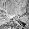
 Exterieur OPGRAVINGEN TEN NOORDWESTEN VAN DE TOREN - Bedum - 20312225 - RCE.jpg 1,176 × 1,200; 471 KB
-
 Exterieur OPGRAVINGEN TEN NOORDWESTEN VAN DE TOREN - Bedum - 20312226 - RCE.jpg 1,192 × 1,200; 454 KB
-
 Exterieur OPGRAVINGEN TEN NOORDWESTEN VAN DE TOREN - Bedum - 20312227 - RCE.jpg 1,197 × 1,200; 496 KB
-
 Exterieur OPGRAVINGEN TEN NOORDWESTEN VAN DE TOREN - Bedum - 20312228 - RCE.jpg 1,190 × 1,200; 497 KB
-
 Exterieur OPGRAVINGEN TEN NOORDWESTEN VAN DE TOREN - Bedum - 20312229 - RCE.jpg 1,181 × 1,200; 468 KB
-
 Exterieur OPGRAVINGEN TEN NOORDWESTEN VAN DE TOREN - Bedum - 20312230 - RCE.jpg 1,172 × 1,200; 452 KB
-
 Exterieur OPGRAVINGEN TEN NOORDWESTEN VAN DE TOREN - Bedum - 20312231 - RCE.jpg 1,179 × 1,200; 432 KB
-
 Exterieur OPGRAVINGEN TEN ZUIDWESTEN VAN DE TOREN - Bedum - 20312235 - RCE.jpg 1,195 × 1,200; 480 KB
-

-
 Exterieur OVERZICHT TOREN - Bedum - 20296586 - RCE.jpg 978 × 1,200; 331 KB
-
 Exterieur TOREN - Bedum - 20296585 - RCE.jpg 949 × 1,200; 230 KB
-
 Exterieur TOREN, ZUIDZIJDE - Bedum - 20296587 - RCE.jpg 957 × 1,200; 246 KB
-
 Exterieur TOREN, ZUIDZIJDE - Bedum - 20296588 - RCE.jpg 985 × 1,200; 372 KB
-
 Exterieur ZUIDGEVEL, RAAMTRACERING - Bedum - 20298956 - RCE.jpg 1,200 × 1,192; 340 KB
-

-
 Exterieur ZUIDGEVEL, VENSTERKOP, PROFILERING, DETAIL - Bedum - 20298957 - RCE.jpg 1,197 × 1,200; 364 KB
-
 Exterieur ZUIDGEVEL, VENSTERKOP, PROFILERING, DETAIL - Bedum - 20298958 - RCE.jpg 1,200 × 1,187; 359 KB
-
 Exterieur ZUIDGEVEL, VENSTERKOP, PROFILERING, DETAIL - Bedum - 20298959 - RCE.jpg 1,188 × 1,200; 365 KB
-
 Exterieur ZUIDGEVEL, VENSTERKOP, PROFILERING, DETAIL - Bedum - 20298960 - RCE.jpg 1,200 × 1,185; 484 KB
-
 Exterieur ZUIDGEVEL, VENSTERKOP, PROFILERING, DETAIL - Bedum - 20298962 - RCE.jpg 1,200 × 1,178; 522 KB
-
 Exterieur ZUIDGEVEL, VENSTERKOP, PROFILERING, DETAIL - Bedum - 20298963 - RCE.jpg 1,200 × 1,199; 408 KB
-
 Exterieur ZUIDGEVEL, VENSTERKOP, PROFILERING, DETAIL - Bedum - 20298964 - RCE.jpg 1,200 × 1,183; 378 KB
-
 Exterieur ZUIDGEVEL, VENSTERKOP, PROFILERING, DETAIL - Bedum - 20298965 - RCE.jpg 1,200 × 1,195; 328 KB
-
 Exterieur ZUIDGEVEL, VENSTERKOP, PROFILERING, DETAIL - Bedum - 20298966 - RCE.jpg 1,200 × 1,188; 380 KB
-
 Exterieur ZUIDGEVEL, VENSTERKOP, PROFILERING, DETAIL - Bedum - 20298967 - RCE.jpg 1,190 × 1,200; 378 KB
-
 Exterieur ZUIDGEVEL, VENSTERKOP, PROFILERING, DETAIL - Bedum - 20298968 - RCE.jpg 1,200 × 1,169; 466 KB
-
 Exterieur, naar het noord-westen - Bedum - 20028685 - RCE.jpg 870 × 1,200; 122 KB
-
 Exterieur, noord gevel - Bedum - 20028688 - RCE.jpg 1,200 × 950; 325 KB
-
 Exterieur, vanuit het noord-oosten - Bedum - 20028686 - RCE.jpg 831 × 1,200; 289 KB
-
 Exterieur, vanuit het zuiden - Bedum - 20028687 - RCE.jpg 1,200 × 827; 279 KB
-
 Exterieur, zuid-oost en zuid-zijde - Bedum - 20028702 - RCE.jpg 970 × 1,200; 242 KB
-
 Exterieur, zuid-oost en zuid-zijde - Bedum - 20028703 - RCE.jpg 858 × 1,200; 216 KB
-
 Het middenraam in de zuidgevel - Bedum - 20400617 - RCE.jpg 1,197 × 1,200; 478 KB
-
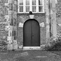
 Ingang (deur) in de zuidzijde bij de oostkant - Bedum - 20400614 - RCE.jpg 1,197 × 1,200; 481 KB
-
 Ingang (deur) in de zuidzijde bij de oostkant - Bedum - 20400616 - RCE.jpg 1,197 × 1,200; 452 KB
-
 Ingang zuidzijde bij de westgevel - Bedum - 20400622 - RCE.jpg 1,200 × 1,197; 397 KB
-
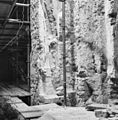
 INT. AANZET GOTISCH VIERINGSGEWELF (TIJDENS ONTMANTELING) - Bedum - 20311660 - RCE.jpg 1,182 × 1,200; 479 KB
-
 INT. AANZET GOTISCH VIERINGSGEWELF (TIJDENS ONTMANTELING) - Bedum - 20311661 - RCE.jpg 1,200 × 1,197; 507 KB
-
 INT. AANZET GOTISCH VIERINGSGEWELF (TIJDENS ONTMANTELING) - Bedum - 20311662 - RCE.jpg 1,183 × 1,200; 440 KB
-
 INT. AANZET GOTISCH VIERINGSGEWELF - Bedum - 20311663 - RCE.jpg 1,200 × 1,180; 398 KB
-
 INT. DWARSPAND, PIJLER - Bedum - 20311673 - RCE.jpg 1,200 × 1,197; 485 KB
-
 INT. MUURPIJLER TUSSEN ZUIDER ZIJBEUK, VOORMALIG BASEMENT - Bedum - 20311657 - RCE.jpg 1,200 × 1,180; 466 KB
-

-
 INT. MUURPIJLER ZUIDER ZIJBEUK, RESTANT BASEMENT - Bedum - 20311659 - RCE.jpg 1,200 × 1,173; 414 KB
-

-
 INT. NOORDBEUK, FUNDERING EERSTE PIJLER - Bedum - 20311671 - RCE.jpg 1,192 × 1,200; 485 KB
-
 INT. NOORDELIJK DWARSPAND, FUNDERING - Bedum - 20311669 - RCE.jpg 1,197 × 1,200; 525 KB
-
 INT. NOORDELIJK DWARSPAND, SCHEIBOOG VIERING, KAPITEEL - Bedum - 20311670 - RCE.jpg 1,192 × 1,200; 458 KB
-
 INT. RECONSTRUCTIE SCHIPPILASTER - Bedum - 20311665 - RCE.jpg 1,200 × 1,187; 404 KB
-

-

-
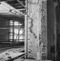 INT. vieringpijler (TIJDENS ONTMANTELING) - Bedum - 20311664 - RCE.jpg 1,177 × 1,200; 342 KB
-

-
 INT. VOORMALIG ZUIDER KOORDOORGANG - Bedum - 20311654 - RCE.jpg 1,197 × 1,200; 463 KB
-

-

-
 INT. ZIJBEUK, PIJLER - Bedum - 20311672 - RCE.jpg 1,200 × 1,197; 463 KB
-

-
 Interieur bouwsporen venster met (vage) traceringen - Bedum - 20323030 - RCE.jpg 1,186 × 1,200; 472 KB
-
 Interieur bouwsporen venster met (vage) traceringen - Bedum - 20323031 - RCE.jpg 1,190 × 1,200; 496 KB
-
 Interieur detail bouwsporen - Bedum - 20323025 - RCE.jpg 1,198 × 1,200; 387 KB
-

-
 Interieur kerk, naar het noord-westen - Bedum - 20381579 - RCE.jpg 1,200 × 1,200; 210 KB
-
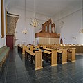
 Interieur kerk, naar het oosten met preekstoel - Bedum - 20381581 - RCE.jpg 1,200 × 1,200; 160 KB
-
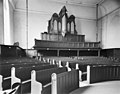
 Interieur kerk, naar het westen met preekstoel en orgel - Bedum - 20381580 - RCE.jpg 1,200 × 1,200; 194 KB
-
 Interieur naar het oosten - Bedum - 20028693 - RCE.jpg 1,200 × 954; 201 KB
-
 Interieur naar het westen - Bedum - 20028695 - RCE.jpg 1,200 × 943; 178 KB
-
 Interieur orgel - Bedum - 20322754 - RCE.jpg 1,200 × 784; 168 KB
-

-

-

-

-
 Interieur toren, oostmuur op 1e verdieping - Bedum - 20381578 - RCE.jpg 1,200 × 1,181; 255 KB
-
 Interieur toren, oostmuur op de begane grond - Bedum - 20381576 - RCE.jpg 1,200 × 1,200; 261 KB
-
 Interieur toren, oostmuur op de begane grond - Bedum - 20381577 - RCE.jpg 1,200 × 1,200; 349 KB
-

-

-

-
 Interieur zijbeuk, deur, tijdens restauratie - Bedum - 20323016 - RCE.jpg 1,190 × 1,200; 361 KB
-
 Interieur zijbeuk, tijdens restauratie - Bedum - 20323009 - RCE.jpg 1,183 × 1,200; 295 KB
-
 Interieur zijbeuk, tijdens restauratie - Bedum - 20323011 - RCE.jpg 1,190 × 1,200; 304 KB
-
 Interieur zijbeuk, tijdens restauratie - Bedum - 20323014 - RCE.jpg 1,186 × 1,200; 338 KB
-
 Interieur zijbeuk, tijdens restauratie - Bedum - 20323015 - RCE.jpg 1,200 × 1,197; 312 KB
-
 INTERIEUR, BASEMENT VAN TRIOMFBOOG, PILASTER - Bedum - 20294449 - RCE.jpg 1,188 × 1,200; 289 KB
-
 Interieur, detail restant van console - Bedum - 20381941 - RCE.jpg 1,200 × 1,200; 208 KB
-
 INTERIEUR, DICHTGEZETTE PISCINIANIS IN DE ZUIDMUUR - Bedum - 20298937 - RCE.jpg 1,200 × 1,183; 555 KB
-
 INTERIEUR, GEDEELTE VAN DE NOORDMUUR (NA ONTPLEISTERING) - Bedum - 20298927 - RCE.jpg 1,200 × 1,187; 416 KB
-
 INTERIEUR, GEDEELTE VAN DE NOORDMUUR (NA ONTPLEISTERING) - Bedum - 20298928 - RCE.jpg 1,200 × 1,199; 451 KB
-
 INTERIEUR, GEDEELTE VAN DE NOORDMUUR (NA ONTPLEISTERING) - Bedum - 20298929 - RCE.jpg 1,200 × 1,174; 503 KB
-
 INTERIEUR, GEDEELTE VAN DE NOORDMUUR - Bedum - 20298930 - RCE.jpg 1,193 × 1,200; 481 KB
-
 INTERIEUR, GEOPENDE PISCINIANIS IN DE ZUIDMUUR - Bedum - 20298936 - RCE.jpg 1,191 × 1,200; 466 KB
-
 INTERIEUR, KAPCONSTRUCTIE IN SLECHTE STAAT - Bedum - 20269809 - RCE.jpg 1,192 × 1,200; 406 KB
-
 INTERIEUR, KAPCONSTRUCTIE IN SLECHTE STAAT - Bedum - 20269810 - RCE.jpg 1,188 × 1,200; 374 KB
-
 INTERIEUR, KAPCONSTRUCTIE IN SLECHTE STAAT - Bedum - 20269811 - RCE.jpg 1,190 × 1,200; 384 KB
-
 INTERIEUR, KAPCONSTRUCTIE IN SLECHTE STAAT - Bedum - 20269812 - RCE.jpg 1,186 × 1,200; 352 KB
-
 INTERIEUR, KAPCONSTRUCTIE IN SLECHTE STAAT - Bedum - 20269813 - RCE.jpg 1,188 × 1,200; 357 KB
-
 INTERIEUR, KAPCONSTRUCTIE IN SLECHTE STAAT - Bedum - 20269814 - RCE.jpg 1,188 × 1,200; 354 KB
-
 INTERIEUR, KAPCONSTRUCTIE IN SLECHTE STAAT - Bedum - 20269815 - RCE.jpg 1,185 × 1,200; 364 KB
-
 INTERIEUR, KAPCONSTRUCTIE IN SLECHTE STAAT - Bedum - 20269816 - RCE.jpg 1,193 × 1,200; 349 KB
-
 INTERIEUR, KAPCONSTRUCTIE IN SLECHTE STAAT - Bedum - 20269817 - RCE.jpg 1,188 × 1,200; 460 KB
-
 INTERIEUR, KAPCONSTRUCTIE IN SLECHTE STAAT - Bedum - 20269818 - RCE.jpg 1,190 × 1,200; 426 KB
-
 INTERIEUR, KAPCONSTRUCTIE IN SLECHTE STAAT - Bedum - 20269819 - RCE.jpg 1,193 × 1,200; 399 KB
-
 INTERIEUR, KAPCONSTRUCTIE IN SLECHTE STAAT - Bedum - 20269820 - RCE.jpg 1,190 × 1,200; 334 KB
-
 INTERIEUR, KAPCONSTRUCTIE IN SLECHTE STAAT - Bedum - 20269821 - RCE.jpg 1,195 × 1,200; 431 KB
-
 INTERIEUR, KAPCONSTRUCTIE IN SLECHTE STAAT - Bedum - 20269822 - RCE.jpg 1,195 × 1,200; 468 KB
-
 INTERIEUR, KAPCONSTRUCTIE IN SLECHTE STAAT - Bedum - 20269823 - RCE.jpg 1,190 × 1,200; 369 KB
-
 INTERIEUR, KAPCONSTRUCTIE IN SLECHTE STAAT - Bedum - 20269824 - RCE.jpg 1,195 × 1,200; 365 KB
-
 INTERIEUR, KOLOM IN HET MIDDEN VAN DE OOSTMUUR - Bedum - 20298942 - RCE.jpg 1,197 × 1,200; 521 KB
-
 INTERIEUR, KOLOM IN NOORDMUUR (KEUKENZIJDE) - Bedum - 20298940 - RCE.jpg 1,186 × 1,200; 331 KB
-

-
 INTERIEUR, KOLOMVOET (BASEMENT) IN NOORDOOST HOEK - Bedum - 20298946 - RCE.jpg 1,198 × 1,200; 462 KB
-
-

-

-

-

-

-
 INTERIEUR, KOLOMVOET IN MUURWERK ZUIDOOST HOEK - Bedum - 20298939 - RCE.jpg 1,197 × 1,200; 530 KB
-
 INTERIEUR, KOOROMGANG, KAPITEEL MET CONSOLE - Bedum - 20294407 - RCE.jpg 1,183 × 1,200; 302 KB
-
 INTERIEUR, KOOROMGANG, KAPITEEL MET CONSOLE - Bedum - 20294408 - RCE.jpg 1,185 × 1,200; 264 KB
-
 INTERIEUR, KOOROMGANG, NOORDER TRANSEPT - Bedum - 20294406 - RCE.jpg 1,200 × 1,195; 304 KB
-
 INTERIEUR, KOOROMGANG, NOORDER TRANSEPT, BOOGAANZET - Bedum - 20294404 - RCE.jpg 1,200 × 1,200; 313 KB
-
 INTERIEUR, KOOROMGANG, NOORDER TRANSEPT, ZUIDOOST HOEK - Bedum - 20294405 - RCE.jpg 1,195 × 1,200; 291 KB
-
 INTERIEUR, KOOROMGANG, ZUIDELIJK PILASTER, KAPITEEL - Bedum - 20294454 - RCE.jpg 1,200 × 1,200; 288 KB
-
 INTERIEUR, METSELWERK BOVEN DOORGANG NOORDMUUR - Bedum - 20298955 - RCE.jpg 1,200 × 1,188; 505 KB
-
 INTERIEUR, MIDDENBEUK, NOORDMUUR - Bedum - 20294439 - RCE.jpg 1,200 × 1,192; 432 KB
-
 INTERIEUR, MIDDENBEUK, NOORDMUUR - Bedum - 20294440 - RCE.jpg 1,200 × 1,192; 374 KB
-

-

-
 INTERIEUR, MIDDENBEUK, NOORDMUUR, VIERDE SCHIPVENSTER - Bedum - 20294425 - RCE.jpg 1,185 × 1,200; 421 KB
-
 INTERIEUR, MIDDENBEUK, WESTMUUR - Bedum - 20294418 - RCE.jpg 1,200 × 1,197; 457 KB
-
 INTERIEUR, MUURSCHILDERING OP NOORDMUUR - Bedum - 20295477 - RCE.jpg 1,196 × 1,200; 250 KB
-
 INTERIEUR, MUURSCHILDERING OP NOORDMUUR - Bedum - 20295478 - RCE.jpg 1,196 × 1,200; 273 KB
-
 INTERIEUR, MUURSCHILDERING OP NOORDMUUR - Bedum - 20295479 - RCE.jpg 1,198 × 1,200; 298 KB
-

-
 INTERIEUR, NOORDBEUK, AANZICHT WESTGEVEL - Bedum - 20294443 - RCE.jpg 1,200 × 1,197; 352 KB
-
 INTERIEUR, NOORDBEUK, BOVENGEDEELTE SCHOORBOOG IN WESTGEVEL - Bedum - 20294444 - RCE.jpg 1,200 × 1,190; 352 KB
-
 INTERIEUR, NOORDBEUK, DERDE SCHEIBOOG - Bedum - 20294446 - RCE.jpg 1,188 × 1,200; 333 KB
-
 INTERIEUR, NOORDBEUK, WESTMUUR, EERSTE SCHEIBOOG - Bedum - 20294447 - RCE.jpg 1,185 × 1,200; 323 KB
-
 INTERIEUR, NOORDBEUK, WESTMUUR, SCHEIBOOG - Bedum - 20294445 - RCE.jpg 1,188 × 1,200; 374 KB
-
 INTERIEUR, NOORDER TRANSEPT, AANZET SCHEIBOOG - Bedum - 20294415 - RCE.jpg 1,197 × 1,200; 349 KB
-
 INTERIEUR, NOORDER TRANSEPT, BASEMENT - Bedum - 20294403 - RCE.jpg 1,200 × 1,200; 297 KB
-

-
 INTERIEUR, NOORDER TRANSEPT, NOORDMUUR, GOTHISCHE CONSOLE - Bedum - 20294401 - RCE.jpg 1,192 × 1,200; 316 KB
-
 INTERIEUR, NOORDER TRANSEPT, NOORDWEST HOEK - Bedum - 20294400 - RCE.jpg 1,197 × 1,200; 407 KB
-

-
 INTERIEUR, NOORDER TRANSEPT, OOSTWAND - Bedum - 20294402 - RCE.jpg 1,195 × 1,200; 241 KB
-
 INTERIEUR, NOORDER TRANSEPT, SCHEIBOOG NAAR VIERING - Bedum - 20294411 - RCE.jpg 1,190 × 1,200; 339 KB
-
 INTERIEUR, NOORDER TRANSEPT, WESTMUUR - Bedum - 20294420 - RCE.jpg 1,190 × 1,200; 400 KB
-
-
 INTERIEUR, NOORDER TRANSEPT, ZUIDOOST HOEK, BOUWNAAD - Bedum - 20294410 - RCE.jpg 1,190 × 1,200; 448 KB
-

-
 INTERIEUR, NOORDER TRANSEPT, ZUIDWEST HOEK, KOLONNET - Bedum - 20294398 - RCE.jpg 1,192 × 1,200; 354 KB
-
 INTERIEUR, NOORDER ZIJBEUK - Bedum - 20294416 - RCE.jpg 1,185 × 1,200; 416 KB
-
 INTERIEUR, NOORDER ZIJBEUK - Bedum - 20294417 - RCE.jpg 1,183 × 1,200; 425 KB
-
 INTERIEUR, NOORDER ZIJBEUK - Bedum - 20294419 - RCE.jpg 1,190 × 1,200; 496 KB
-
 INTERIEUR, NOORDER ZIJBEUK - Bedum - 20294422 - RCE.jpg 1,200 × 1,178; 397 KB
-

-

-

-
 INTERIEUR, NOORDER ZIJBEUK, VIERDE SCHEIBOOG - Bedum - 20294442 - RCE.jpg 1,200 × 1,197; 231 KB
-
 INTERIEUR, NOORDMUUR MIDDENBEUK - Bedum - 20294424 - RCE.jpg 1,200 × 1,200; 519 KB
-
 INTERIEUR, NOORDMUUR MIDDENBEUK TEN WESTEN VAN SCHOORMUUR - Bedum - 20294436 - RCE.jpg 1,200 × 1,200; 459 KB
-

-
 INTERIEUR, NOORDMUUR, MIDDENBEUK - Bedum - 20294421 - RCE.jpg 1,195 × 1,200; 390 KB
-
 INTERIEUR, NOORDMUUR, MIDDENBEUK - Bedum - 20294423 - RCE.jpg 1,200 × 1,195; 436 KB
-

-
-
 INTERIEUR, NOORDMUUR, MIDDENBEUK MET TWEEDE SCHIPVENSTER - Bedum - 20294430 - RCE.jpg 1,197 × 1,200; 421 KB
-
 INTERIEUR, NOORDMUUR, MIDDENBEUK, TWEEDE SCHIPVENSTER - Bedum - 20294431 - RCE.jpg 1,200 × 1,200; 440 KB
-
 INTERIEUR, NOORDMUUR, MIDDENBEUK, TWEEDE SCHIPVENSTER - Bedum - 20294433 - RCE.jpg 1,185 × 1,200; 455 KB
-
 INTERIEUR, NOORDMUUR, MIDDENBEUK, TWEEDE SCHIPVENSTER - Bedum - 20294434 - RCE.jpg 1,195 × 1,200; 464 KB
-
 INTERIEUR, OOSTELIJKE TRAVEE - Bedum - 20294441 - RCE.jpg 1,192 × 1,200; 244 KB
-
 INTERIEUR, OOSTMUUR BIJ NOORDMUUR - Bedum - 20298931 - RCE.jpg 951 × 1,200; 308 KB
-
 INTERIEUR, OOSTMUUR BIJ ZUIDMUUR - Bedum - 20298932 - RCE.jpg 954 × 1,200; 318 KB
-
 INTERIEUR, OOSTMUUR, AANZET GEWELFBOOG - Bedum - 20298943 - RCE.jpg 1,200 × 1,192; 484 KB
-
 INTERIEUR, OOSTMUUR, VENSTER BOVEN WESTELIJKE GORDELBOOG - Bedum - 20294396 - RCE.jpg 1,200 × 1,200; 544 KB
-

-
 INTERIEUR, ORGEL - Bedum - 20275581 - RCE.jpg 1,200 × 960; 173 KB
-
 INTERIEUR, OVERZICHT NAAR HET NOORDWESTEN - Bedum - 20298924 - RCE.jpg 946 × 1,200; 279 KB
-
 INTERIEUR, OVERZICHT NAAR HET OOSTEN - Bedum - 20298920 - RCE.jpg 1,195 × 1,200; 288 KB
-


_in_de_zuidzijde_bij_de_oostkant_-_Bedum_-_20400614_-_RCE.jpg)
_in_de_zuidzijde_bij_de_oostkant_-_Bedum_-_20400616_-_RCE.jpg)

_-_Bedum_-_20311660_-_RCE.jpg)
_-_Bedum_-_20311661_-_RCE.jpg)
_-_Bedum_-_20311662_-_RCE.jpg)


_-_Bedum_-_20311655_-_RCE.jpg)

_-_Bedum_-_20311656_-_RCE.jpg)


_-_Bedum_-_20311666_-_RCE.jpg)

_-_Bedum_-_20311664_-_RCE.jpg)


_traceringen_-_Bedum_-_20323030_-_RCE.jpg)
_traceringen_-_Bedum_-_20323031_-_RCE.jpg)


_-_Bedum_-_20298927_-_RCE.jpg)
_-_Bedum_-_20298928_-_RCE.jpg)
_-_Bedum_-_20298929_-_RCE.jpg)


_-_Bedum_-_20298940_-_RCE.jpg)
_IN_HET_MIDDEN_VAN_DE_OOSTMUUR_-_Bedum_-_20298944_-_RCE.jpg)
_IN_NOORDOOST_HOEK_-_Bedum_-_20298946_-_RCE.jpg)
_IN_NOORMUUR_BIJ_VOORMALIGE_SCHEIDINGSMUUR_-_Bedum_-_20298954_-_RCE.jpg)
_IN_VOORMALIGE_SCHEIDINGSMUUR_-_Bedum_-_20298951_-_RCE.jpg)
_IN_VOORMALIGE_SCHEIDINGSMUUR_-_Bedum_-_20298952_-_RCE.jpg)
_IN_VOORMALIGE_SCHEIDINGSMUUR_-_Bedum_-_20298953_-_RCE.jpg)
_IN_VOORMALIGE_SCHEIDINGSMUUR_OOSTZIJDE_-_Bedum_-_20298950_-_RCE.jpg)


_GEWELF_-_Bedum_-_20294414_-_RCE.jpg)