Category:Vredebest (Pijnacker)
Jump to navigation
Jump to search
| Object location | | View all coordinates using: OpenStreetMap |
|---|
| Upload media | |||||
| Instance of | |||||
|---|---|---|---|---|---|
| Location | Pijnacker, Pijnacker | ||||
| Has part(s) | |||||
| Heritage designation |
| ||||
 | |||||
Nederlands: Boerderij Vredebest
|
This is a category about rijksmonumentcomplex number 525175
|
Boerderij
|
This is a category about rijksmonument number 32262
|
Wagenschuur
|
This is a category about rijksmonument number 525176
|
Toegangshek
|
This is a category about rijksmonument number 525177
|
Hooiberg
|
This is a category about rijksmonument number 525178
|
| Address |
|
Media in category "Vredebest (Pijnacker)"
The following 13 files are in this category, out of 13 total.
-
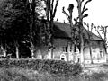
 Aanzicht - Pijnacker - 20182471 - RCE.jpg 1,200 × 814; 314 KB
-
 Overzicht - Pijnacker - 20182472 - RCE.jpg 1,200 × 791; 306 KB
-
 Overzicht - Pijnacker - 20182473 - RCE.jpg 1,200 × 822; 313 KB
-

-
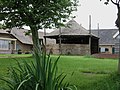
 Pijnacker - Overgauwseweg 50 (boerderij).jpg 2,592 × 1,944; 1.5 MB
-
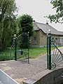 Pijnacker - Overgauwseweg 50 (hek).jpg 1,944 × 2,592; 1.59 MB
-
 Pijnacker - Overgauwseweg 50 (hooiberg).jpg 2,592 × 1,944; 1.52 MB
-
 Pijnacker - Overgauwseweg 50 (wagenschuur).jpg 1,944 × 2,592; 1.2 MB
-
 Voor- en zijgevel inrijhek nr. QB 3 - Pijnacker - 20466182 - RCE.jpg 1,200 × 900; 268 KB
-
 Voor- en zijgevel repro fotonr. 2895, J.Verheul - Pijnacker - 20466185 - RCE.jpg 1,200 × 900; 142 KB
-
 Voorgevel - Pijnacker - 20182474 - RCE.jpg 1,200 × 804; 279 KB
-
 Voorgevel woongedeelte nr. QB 4 - Pijnacker - 20466183 - RCE.jpg 1,200 × 900; 245 KB
-
 Voorgevel woongedeelte nr. QB 5 - Pijnacker - 20466184 - RCE.jpg 1,200 × 900; 229 KB


.jpg)
.jpg)
.jpg)
.jpg)


