Category:Vorderstoder
Jump to navigation
Jump to search
municipality in Kirchdorf District, Upper Austria, Austria   | |||||
| Upload media | |||||
| Instance of |
| ||||
|---|---|---|---|---|---|
| Location | Kirchdorf District, Upper Austria, Austria | ||||
| Population |
| ||||
| Area |
| ||||
| Elevation above sea level |
| ||||
| official website | |||||
 | |||||
Subcategories
This category has the following 4 subcategories, out of 4 total.
Media in category "Vorderstoder"
The following 14 files are in this category, out of 14 total.
-
 Bücherzelle-Vorderstoder.jpg 4,128 × 3,096; 5.98 MB
-
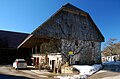 Farmhouse, Vorderstoder.jpg 2,984 × 1,968; 2.58 MB
-
 Fire station Vorderstoder.jpg 2,872 × 1,940; 3.96 MB
-
 Map at vorderstoder.png 400 × 240; 3 KB
-
 Pfarrhof-vorderstoder-austria.jpg 3,035 × 2,561; 4.28 MB
-
 Täglich geöffnet - Mittwoch Ruhetag.jpg 2,000 × 3,008; 3.68 MB
-
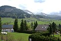 Vorderstoder 0002.jpg 1,900 × 1,272; 518 KB
-
 Vorderstoder im Bezirk KI.png 645 × 645; 25 KB
-
 Vorderstoder Ortsansicht-10492.jpg 6,000 × 3,375; 8.03 MB
-
 Vorderstoder Schafferteich.JPG 4,288 × 2,848; 2.66 MB
-
 Vorderstoder Steyrsbergerreith Spitzmauer.JPG 4,288 × 2,848; 3.41 MB
-
 Vorderstoder, Franz Josef I. memorial.jpg 1,695 × 2,954; 861 KB
-
 Vorderstoder, Kleiner Priel.jpg 2,996 × 1,944; 2.97 MB
-
 Wappen at vorderstoder.jpg 166 × 207; 26 KB


