Category:Vorden Castle
Jump to navigation
Jump to search
| Object location | | View all coordinates using: OpenStreetMap |
|---|
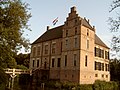
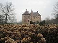
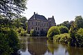
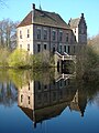
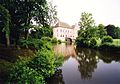
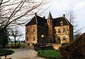
house in Bronckhorst, Netherlands  | |||||
| Upload media | |||||
| Instance of | |||||
|---|---|---|---|---|---|
| Part of | |||||
| Location | Vorden, Gelderland, Netherlands | ||||
| Street address |
| ||||
| Located on street |
| ||||
| Heritage designation |
| ||||
 | |||||
Voormalig rijksmonumentnummer:
|
This is a category about rijksmonument number 38137
|
Complex:
|
This is a category about rijksmonument number 526291
|
Kasteel:
|
This is a category about rijksmonument number 526292
|
Historische aanleg:
|
This is a category about rijksmonument number 526293
|
Brug:
|
This is a category about rijksmonument number 526294
|
Koetshuis:
|
This is a category about rijksmonument number 526295
|
Boerderij van het losse hoes-type:
|
This is a category about rijksmonument number 526296
|
Boerderij van het hallenhuistype:
|
This is a category about rijksmonument number 526297
|
Grot:
|
This is a category about rijksmonument number 526291
|
| Address |
|
Media in category "Vorden Castle"
The following 102 files are in this category, out of 102 total.
-
 2006-09-06 17.40 Vorden, kasteel Vorden foto3.JPG 2,272 × 1,704; 1.52 MB
-
 7251 Vorden, Netherlands - panoramio (10).jpg 2,048 × 1,148; 493 KB
-
 7251 Vorden, Netherlands - panoramio (11).jpg 2,048 × 1,148; 492 KB
-
 7251 Vorden, Netherlands - panoramio (13).jpg 1,148 × 2,048; 500 KB
-
 7251 Vorden, Netherlands - panoramio (14).jpg 2,048 × 1,148; 411 KB
-
 7251 Vorden, Netherlands - panoramio (15).jpg 2,048 × 1,148; 750 KB
-
 7251 Vorden, Netherlands - panoramio (23).jpg 1,148 × 2,048; 555 KB
-
 7251 Vorden, Netherlands - panoramio (27).jpg 2,048 × 1,148; 871 KB
-
 7251 Vorden, Netherlands - panoramio (32).jpg 2,048 × 1,148; 737 KB
-
 7251 Vorden, Netherlands - panoramio (48).jpg 4,896 × 3,264; 3.09 MB
-
 7251 Vorden, Netherlands - panoramio (49).jpg 4,896 × 3,264; 3.49 MB
-
 7251 Vorden, Netherlands - panoramio (50).jpg 4,896 × 3,264; 3.08 MB
-
 7251 Vorden, Netherlands - panoramio (51).jpg 4,896 × 3,264; 3.48 MB
-
 7251 Vorden, Netherlands - panoramio (52).jpg 4,896 × 3,264; 3.02 MB
-
 7251 Vorden, Netherlands - panoramio (53).jpg 4,896 × 3,264; 3.45 MB
-
 7251 Vorden, Netherlands - panoramio (54).jpg 4,896 × 3,264; 3.37 MB
-
 7251 Vorden, Netherlands - panoramio (55).jpg 4,896 × 3,264; 3.62 MB
-
 7251 Vorden, Netherlands - panoramio (56).jpg 4,896 × 3,264; 2.92 MB
-
 7251 Vorden, Netherlands - panoramio (57).jpg 4,896 × 3,264; 2.41 MB
-
 Begraafplaats Vorden.jpg 4,000 × 3,000; 4.17 MB
-
 Beschilderde houten wand op 1e verdieping - Vorden - 20246915 - RCE.jpg 1,192 × 1,200; 243 KB
-
 Beschilderde houten wand op 1e verdieping. - Vorden - 20246914 - RCE.jpg 1,190 × 1,200; 254 KB
-
 Beschilderde houten wand op 1e verdieping. - Vorden - 20357294 - RCE.jpg 1,200 × 1,193; 220 KB
-
 Bramel vorden.jpg 500 × 793; 85 KB
-
 Castle Vorden 01.JPG 4,320 × 3,240; 3.21 MB
-
 Castle Vorden 02.JPG 4,183 × 3,080; 2.59 MB
-
 Castle Vorden 03.JPG 4,320 × 3,240; 3.05 MB
-
 Castle Vorden 04.JPG 4,320 × 3,240; 3.24 MB
-
 Castle Vorden 05.JPG 4,320 × 3,240; 3.58 MB
-
 Castle Vorden 06.JPG 4,320 × 3,240; 3.94 MB
-
 Castle Vorden 07.JPG 4,320 × 3,240; 3.71 MB
-
 Castle Vorden 08.JPG 4,320 × 3,240; 3.53 MB
-
 Castle Vorden 09.JPG 4,320 × 3,240; 3.84 MB
-
 Castle Vorden 10.JPG 4,320 × 3,240; 2.69 MB
-
 Castle Vorden 11.JPG 4,320 × 3,240; 2.79 MB
-
 Castle Vorden 12.JPG 4,320 × 3,240; 3.47 MB
-
 Castle Vorden for visiting and tearoom at Saturday 24 August 2013 - panoramio.jpg 4,928 × 3,264; 8.96 MB
-
 Castle Vorden Holland in spring with nice reflection - panoramio.jpg 3,552 × 2,368; 3.45 MB
-
 Exterieur - Vorden - 20246906 - RCE.jpg 950 × 1,200; 305 KB
-
 Exterieur BRUG BIJ HET PARK - Vorden - 20291658 - RCE.jpg 1,200 × 1,200; 476 KB
-
 Exterieur HEKWERK OP VOORPLEIN, NAAST BRUG - Vorden - 20291657 - RCE.jpg 1,188 × 1,200; 423 KB
-
 Exterieur HOOFDINGANG - Vorden - 20291654 - RCE.jpg 1,192 × 1,200; 416 KB
-
 Exterieur IJZEREN VOETSCHRAPER - Vorden - 20291659 - RCE.jpg 1,200 × 1,200; 399 KB
-
 Exterieur OVERZICHT - Vorden - 20291651 - RCE.jpg 1,183 × 1,200; 360 KB
-
 Exterieur OVERZICHT BESTRATING NAAR BIJGEBOUWEN - Vorden - 20291655 - RCE.jpg 1,188 × 1,200; 406 KB
-
 Exterieur OVERZICHT BESTRATING VOORPLEIN - Vorden - 20291656 - RCE.jpg 1,190 × 1,200; 408 KB
-
 Exterieur OVERZICHT VOORZIJDE - Vorden - 20291649 - RCE.jpg 1,200 × 1,195; 401 KB
-
 Exterieur OVERZICHT VOORZIJDE - Vorden - 20291650 - RCE.jpg 1,200 × 1,195; 403 KB
-
 Exterieur OVERZICHT VOORZIJDE - Vorden - 20291652 - RCE.jpg 1,200 × 1,198; 332 KB
-
 Exterieur OVERZICHT VOORZIJDE - Vorden - 20291653 - RCE.jpg 1,197 × 1,200; 399 KB
-
 Exterieur VOORGEVEL - Vorden - 20265806 - RCE.jpg 868 × 1,200; 283 KB
-
 Gevels - Vorden - 20246898 - RCE.jpg 1,200 × 955; 321 KB
-
 Gevels - Vorden - 20246899 - RCE.jpg 1,200 × 958; 230 KB
-
 Gevels - Vorden - 20246900 - RCE.jpg 959 × 1,200; 296 KB
-
 Gevels - Vorden - 20246901 - RCE.jpg 971 × 1,200; 374 KB
-
 Grafkelder Huize Vorden.jpg 4,000 × 3,000; 4.43 MB
-
-
 Ingang zuid-zijde - Vorden - 20246902 - RCE.jpg 971 × 1,200; 348 KB
-
 INT. ZAAL, SCHOUW MET HAARDPLAAT - Vorden - 20339721 - RCE.jpg 1,183 × 1,200; 276 KB
-
 Interieur detail - Vorden - 20246913 - RCE.jpg 1,192 × 1,200; 309 KB
-
 Interieur schouw - Vorden - 20246911 - RCE.jpg 1,192 × 1,200; 377 KB
-
 Interieur schouw - Vorden - 20246912 - RCE.jpg 1,200 × 1,192; 348 KB
-
 Kasteel te vorden.jpg 3,037 × 1,925; 3.69 MB
-
 Kasteel Vorden (Explore) (7101249145).jpg 3,877 × 3,530; 13.77 MB
-
 Kasteel Vorden 2018.jpg 4,000 × 6,000; 9.53 MB
-
 Kasteel Vorden achterzijde brug.jpg 4,000 × 3,000; 3.08 MB
-
 Kasteel Vorden bijgebouw.jpg 4,000 × 3,000; 2.24 MB
-
 Kasteel Vorden Harnas 01.jpg 4,000 × 3,000; 2.29 MB
-
 Kasteel Vorden in de mist.jpg 3,024 × 4,032; 3.96 MB
-
 Kasteel Vorden Provinciaal besluit 1823.jpg 4,000 × 3,000; 2.15 MB
-
 Kasteel Vorden voorzijde.jpg 4,000 × 3,000; 2.97 MB
-
 Kasteel Vorden Vorden Castle Bronckhorst Achterhoek Netherlands 1315 Schloss Vorden 2.jpg 6,016 × 4,000; 13.86 MB
-
 Kasteel Vorden Vorden Castle Bronckhorst Achterhoek Netherlands 1315 Schloss Vorden 4.jpg 6,016 × 4,000; 16.25 MB
-
 Kasteel Vorden Vorden Castle Bronckhorst Achterhoek Netherlands 1315 Schloss Vorden.jpg 6,016 × 4,000; 3.71 MB
-
 Kasteel Vorden Wapen van Vorden in glas.jpg 4,000 × 3,000; 2.17 MB
-
 Kasteel Vorden Wapen van Vorden.jpg 4,000 × 3,000; 2.6 MB
-
 Kasteel Vorden zijkant.jpg 4,000 × 3,000; 3.52 MB
-
 Kasteel Vorden.jpg 1,600 × 1,200; 609 KB
-
 Kasteel Vorden1.jpg 374 × 464; 29 KB
-
 KasteelVorden.jpg 778 × 606; 214 KB
-

-
 Overzicht met gracht - Vorden - 20246907 - RCE.jpg 894 × 1,200; 233 KB
-
 Overzicht met toegangsbrug en gracht - Vorden - 20246908 - RCE.jpg 1,200 × 894; 253 KB
-

-

-

-
-

-
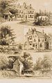
 Reproductie van tekening van J.de Beyer - Vorden - 20246909 - RCE.jpg 1,200 × 958; 206 KB
-
 Restant schouw in de kamer boven traptorentje - Vorden - 20246916 - RCE.jpg 800 × 1,200; 281 KB
-
 Vorden 038.JPG 2,448 × 3,264; 2.25 MB
-
 Vorden 041.JPG 3,264 × 2,448; 2.6 MB
-
 Vorden 046.JPG 2,448 × 3,264; 2.53 MB
-
 Vorden koetshuis.jpg 2,135 × 1,469; 587 KB
-
 Vorden park.jpg 2,124 × 1,482; 653 KB
-
 Vorden, huis Vorden RM526292 IMG 5859 2020-06-01 08.44.jpg 4,650 × 3,111; 9.09 MB
-
 Vorden, kasteel - panoramio.jpg 5,287 × 2,245; 3.68 MB
-
 Vorden,Huis Vorden RM526292.jpg 3,648 × 2,736; 10.07 MB
-
 Vorden.jpg 2,136 × 1,470; 596 KB
-
 Zandstenen trapspil - Vorden - 20246904 - RCE.jpg 956 × 1,200; 144 KB
-
 Zandstenen trapspil - Vorden - 20246905 - RCE.jpg 946 × 1,200; 142 KB
-
 Zwarte Piet bij Kasteel Vorden.JPG 3,240 × 4,320; 2.61 MB

.jpg)
.jpg)
.jpg)
.jpg)
.jpg)
.jpg)
.jpg)
.jpg)
.jpg)
.jpg)
.jpg)
.jpg)
.jpg)
.jpg)
.jpg)
.jpg)
.jpg)
.jpg)


_(7101249145).jpg)


