Category:Voorstraat 485, Dordrecht
Jump to navigation
Jump to search
| Object location | | View all coordinates using: OpenStreetMap |
|---|
 | |||||
| Upload media | |||||
| Instance of |
| ||||
|---|---|---|---|---|---|
| Location | Dordrecht, South Holland, Netherlands | ||||
| Street address |
| ||||
| Heritage designation |
| ||||
 | |||||
|
This is a category about rijksmonument number 13843
|
| Address |
|
Media in category "Voorstraat 485, Dordrecht"
The following 14 files are in this category, out of 14 total.
-
 Boogjes, 3311 Dordrecht, Netherlands - panoramio.jpg 2,048 × 1,375; 362 KB
-
 Gevels - Dordrecht - 20063000 - RCE.jpg 963 × 1,200; 228 KB
-
 Overzicht - Dordrecht - 20063002 - RCE.jpg 955 × 1,200; 192 KB
-
 Overzicht - Dordrecht - 20063004 - RCE.jpg 954 × 1,200; 231 KB
-
 Overzicht - Dordrecht - 20063005 - RCE.jpg 965 × 1,200; 249 KB
-
 Overzicht - Dordrecht - 20063006 - RCE.jpg 1,200 × 957; 273 KB
-
 Pottenkade.jpg 800 × 600; 87 KB
-
 RM13842 Dordrecht - Voorstraat 483.jpg 2,448 × 3,264; 2.17 MB
-
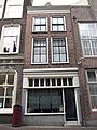 RM13843 Dordrecht - Voorstraat 485.jpg 2,448 × 3,264; 2.19 MB
-
 Voorgevel - Dordrecht - 20062999 - RCE.jpg 804 × 1,200; 204 KB
-
 Voorgevels - Dordrecht - 20062997 - RCE.jpg 953 × 1,200; 264 KB
-
 Voorstraat - Dordrecht - 20060191 - RCE.jpg 1,197 × 1,200; 295 KB
-
 Wijnstraat, 3311 Dordrecht, Netherlands - panoramio (13).jpg 2,048 × 1,148; 501 KB
-
 Zicht in de Voorstraat, straatbeeld - Dordrecht - 20062730 - RCE.jpg 897 × 1,200; 249 KB


.jpg)
