Category:Ville close de Bellême
Jump to navigation
Jump to search
|
This building is inscrit au titre des monuments historiques de la France. It is indexed in the base Mérimée, a database of architectural heritage maintained by the French Ministry of Culture, under the reference PA00110744
|
| Object location | | View all coordinates using: OpenStreetMap |
|---|
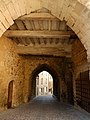
.jpg) La porte Saint-Sauveur, appelé aujourd'hui le porche, vue depuis le sud-ouest. | |||||
| Upload media | |||||
| Instance of | |||||
|---|---|---|---|---|---|
| Location | Bellême, canton of Bellême | ||||
| Owned by | |||||
| Heritage designation |
| ||||
 | |||||
Media in category "Ville close de Bellême"
The following 7 files are in this category, out of 7 total.
-
 Bellême - Gate.JPG 3,264 × 2,448; 3.56 MB
-
 Bellême - porche en 2016.jpg 2,448 × 3,264; 1.72 MB
-
 Bellême - porte fortifiée de la ville close (2).jpg 2,112 × 2,816; 2.4 MB
-
 Bellême - porte fortifiée de la ville close (3).jpg 2,112 × 2,816; 2.48 MB
-
 Bellême - porte fortifiée de la ville close.jpg 2,497 × 2,067; 1.87 MB
-
 Bellême, la rue ville close.JPG 3,456 × 2,304; 3.45 MB
-
 Bellême, le porche de l'ancien château.jpg 4,928 × 3,264; 7.28 MB


.jpg)


