Category:Villa Brakkenstein
Jump to navigation
Jump to search
| Object location | | View all coordinates using: OpenStreetMap |
|---|
 | |||||
| Upload media | |||||
| Instance of | |||||
|---|---|---|---|---|---|
| Part of | |||||
| Location | Nijmegen, Gelderland, Netherlands | ||||
| Heritage designation |
| ||||
 | |||||
|
This is a category about rijksmonumentcomplex number 522926
|
Brakkesteyn
|
This is a category about rijksmonument number 522927
|
Dressuurstal Brakkenstein
|
This is a category about rijksmonument number 522928
|
Tuinmanswoning
|
This is a category about rijksmonument number 522929
|
Schelpenhuis
|
This is a category about rijksmonument number 522930
|
Waterput
|
This is a category about rijksmonument number 522931
|
Toegangshek
|
This is a category about rijksmonument number 522932
|
Park Brakkenstein
|
This is a category about rijksmonument number 522933
|
| Address |
|
Media in category "Villa Brakkenstein"
The following 21 files are in this category, out of 21 total.
-
 Chalet brakkestein - panoramio.jpg 1,024 × 768; 579 KB
-
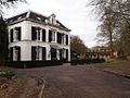
 Driehuizerweg 285 - Villa Brakkenstein (gebouwd 1865) - F26379 - Van der Grinten.jpg 2,085 × 1,497; 550 KB
-
 Driehuizerweg 285 - Villa Brakkenstein (gebouwd 1865) - F78170 - Van der Grinten.jpg 2,952 × 2,025; 463 KB
-
 Driehuizerweg 285 - Villa Brakkenstein (gebouwd 1865) - F78171 - Van der Grinten.jpg 2,958 × 2,004; 550 KB
-
Eerste exemplaar boek Brakkenstein aangeboden.webm 2 min 17 s, 1,920 × 1,080; 37.17 MB
-
 Exterieur OVERZICHT VOORGEVEL, LINKER ZIJGEVEL - Nijmegen - 20339504 - RCE.jpg 1,190 × 1,200; 357 KB
-
 Exterieur STALGEBOUW, POORT - Nijmegen - 20339503 - RCE.jpg 1,181 × 1,200; 376 KB
-
 Het Chalet Brakkenstein F21359.jpeg 1,152 × 1,436; 273 KB
-
 Het Chalet Brakkenstein, aan de d' Almarasweg; -2 december 1965 F21360.jpeg 2,120 × 1,415; 460 KB
-
 Nijmegen plantenbak landgoed Brakkesteijn.jpg 3,648 × 2,736; 4.29 MB
-
 Nijmegen Rijksmonument 522927 Villa langdoed Brakkesteijn.JPG 3,648 × 2,736; 4.13 MB
-
 Nijmegen Rijksmonument 522928 dressuurstal langoed Brakkesteijn.JPG 3,648 × 2,736; 4.24 MB
-
 Nijmegen Rijksmonument 522929 tuinmanshuis landgoed Brakkesteijn.JPG 3,648 × 2,736; 4.26 MB
-
 Nijmegen Rijksmonument 522930 schelpenhuisje landgoed Brakkesteijn, detail.JPG 2,736 × 3,648; 3.46 MB
-
 Nijmegen Rijksmonument 522930 schelpenhuisje landgoed Brakkesteijn.JPG 3,648 × 2,736; 4.21 MB
-
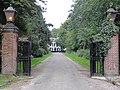 Nijmegen Rijksmonument 522932 toegangshekken landgoed Brakkesteijn.JPG 3,648 × 2,736; 4.18 MB
-
 Overzicht voorgevel stalgebouw met tuinmanswoning - Nijmegen - 20359506 - RCE.jpg 1,178 × 1,200; 323 KB
-
 Stalgebouw met koetshuis, landgoed Brakkesteyn, Architect A. Jacot, Nijmegen 1906.jpg 6,063 × 3,852; 14.13 MB
-
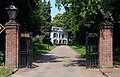 Toegangshekken landgoed Brakkesteyn Nijmegen.jpg 5,736 × 3,685; 10.81 MB
-
 Villa Brakkensteyn, huize Brakkesteyn Heyendaal, Nijmegen 1865.jpg 5,977 × 3,809; 12.41 MB
-
 Waterput Landgoed Brakkensteyn, Driehuizerweg 285, Nijmegen.jpg 2,578 × 3,317; 3.38 MB

_-_F26379_-_Van_der_Grinten.jpg)
_-_F78170_-_Van_der_Grinten.jpg)
_-_F78171_-_Van_der_Grinten.jpg)


