Category:Vijverhof, Nieuwersluis
Jump to navigation
Jump to search
| Object location | | View all coordinates using: OpenStreetMap |
|---|
 | |||||
| Upload media | |||||
| Instance of |
| ||||
|---|---|---|---|---|---|
| Location | Nieuwersluis, Stichtse Vecht, Utrecht, Netherlands | ||||
| Street address |
| ||||
| Located on street |
| ||||
| Heritage designation |
| ||||
 | |||||
Nederlands: Vijverhof, buitenplaats bij het Nederlandse dorp Nieuwersluis, gesticht circa 1670.
|
This is a category about rijksmonument number 520405
|
| Address |
|
Media in category "Vijverhof, Nieuwersluis"
The following 14 files are in this category, out of 14 total.
-
 Albert van Spiers - A floral frontispiece with a portrait medallion of Agnes Block.jpg 1,085 × 1,412; 262 KB
-

-

-
 Daniel Stoopendael - Vijverhof in Loenen aan de Vecht.jpg 1,200 × 923; 188 KB
-
 David van der Plas - Magdalena Poulle with Nephew Pieter 1683.jpg 320 × 320; 46 KB
-

-
 HUA-107507-Gezicht op de Vecht bij Loenen met rechts het huis Vijverhof.jpg 4,018 × 2,753; 2.85 MB
-

-
 HUA-135626-Gezicht op de Vecht bij Loenen met rechts het huis Vijverhof.jpg 3,733 × 2,983; 4.21 MB
-
 HUA-135730-Gezicht op de Vecht bij Loenen met rechts het huis Vijverhof.jpg 3,811 × 3,044; 4.66 MB
-
 HUA-135814-Gezicht op de Vecht bij Loenen met rechts het huis Vijverhof.jpg 3,860 × 2,932; 3.98 MB
-
 HUA-202037-Gezicht op de Vecht bij Loenen met rechts het huis Vijverhof.jpg 1,983 × 1,560; 872 KB
-
 Jan Weenix - Agneta Block and garden Flora Batava.jpg 1,171 × 873; 141 KB
-
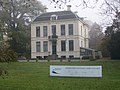 Nieuwersluis NIOO.JPG 2,816 × 2,112; 1.93 MB


