Category:Verbois dam
Jump to navigation
Jump to search
| Object location | | View all coordinates using: OpenStreetMap |
|---|
bridge  | |||||
| Upload media | |||||
| Instance of | |||||
|---|---|---|---|---|---|
| Location |
| ||||
| Located in or next to body of water | |||||
| Owned by | |||||
| Service entry |
| ||||
| Inception |
| ||||
| Nominal power capacity |
| ||||
| Length |
| ||||
| Elevation above sea level |
| ||||
 | |||||
Subcategories
This category has the following 4 subcategories, out of 4 total.
Media in category "Verbois dam"
The following 44 files are in this category, out of 44 total.
-
 1288 Aire-la-Ville, Switzerland - panoramio (2).jpg 2,272 × 1,704; 916 KB
-
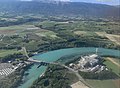
 20100829-Verbois.jpg 1,583 × 526; 273 KB
-
 Barrage de Verbois (12900328553).jpg 5,184 × 3,456; 7.69 MB
-
 Barrage de Verbois (12900332163).jpg 5,184 × 3,456; 7.98 MB
-
 Barrage de Verbois (12900647914).jpg 5,184 × 3,456; 7.32 MB
-
 Barrage de Verbois - panoramio (1).jpg 5,184 × 3,456; 6.42 MB
-
 Barrage de Verbois - panoramio (2).jpg 5,184 × 3,456; 7.57 MB
-
 Barrage de Verbois - panoramio (3).jpg 5,184 × 3,456; 7.13 MB
-
 Barrage de Verbois - panoramio.jpg 5,184 × 3,456; 7.26 MB
-
 Barrage de Verbois @ Aire-la-Ville @ Geneva (50401899258).jpg 6,240 × 4,160; 12.06 MB
-
 Barrage de Verbois @ Aire-la-Ville @ Geneva (50402595471).jpg 6,240 × 4,160; 15.43 MB
-
 Barrage de Verbois @ Russin (51479044331).jpg 4,896 × 3,672; 6.12 MB
-
 Barrage de Verbois @ Russin (51479044466).jpg 6,240 × 4,160; 9.23 MB
-
 Barrage de Verbois @ Russin (51479275183).jpg 6,240 × 4,160; 8.36 MB
-
 Barrage de Verbois @ Russin @ Geneva (50401894543).jpg 6,240 × 4,160; 13.32 MB
-
 Barrage de Verbois @ Russin @ Geneva (50401904648).jpg 6,240 × 4,160; 15.66 MB
-
 Barrage de Verbois @ Russin @ Geneva (50401906263).jpg 6,240 × 4,160; 14.85 MB
-
 Barrage de Verbois @ Russin @ Geneva (50402599961).jpg 6,240 × 4,160; 12.81 MB
-
 Barrage de Verbois @ Russin @ Geneva (50402601251).jpg 6,240 × 4,160; 13.92 MB
-
 Barrage de Verbois @ Russin @ Geneva (50402602151).jpg 6,240 × 4,160; 15.07 MB
-
 Barrage de Verbois @ Russin @ Geneva (50402602871).jpg 6,240 × 4,160; 14.58 MB
-
 Barrage de Verbois @ Russin @ Geneva (50402605676).jpg 6,240 × 4,160; 14.65 MB
-
 Barrage de Verbois @ Russin @ Geneva (50402750687).jpg 6,240 × 4,160; 13.59 MB
-
 Cheneviers et Verbois.jpg 3,582 × 2,640; 2.81 MB
-
 Dam turbine @ Barrage de Verbois @ Russin @ Geneva (50397233798).jpg 6,240 × 4,160; 16.54 MB
-
 Dam turbine @ Barrage de Verbois @ Russin @ Geneva (50402769212).jpg 4,160 × 6,240; 12.77 MB
-
 Dam turbine @ Barrage de Verbois @ Russin @ Geneva (50402770177).jpg 6,240 × 4,160; 15.9 MB
-
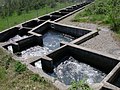 Echelle-poisson-verbois.JPG 2,016 × 1,512; 723 KB
-

-
 Empty fish ladder (2).jpg 2,448 × 3,264; 3.2 MB
-
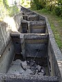 Empty fish ladder.jpg 2,448 × 3,264; 3.38 MB
-
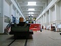 Interieur du Barrage de Verbois.jpg 640 × 480; 99 KB
-
 Plane @ Barrage de Verbois @ Aire-la-Ville @ Geneva (50401899813).jpg 6,240 × 4,160; 9.89 MB
-
 Solar panels @ Barrage de Verbois @ Teppes de Verbois @ Russin @ Geneva (50403194318).jpg 6,240 × 4,160; 15.83 MB
-
 Turbine du Barrage de Verbois.jpg 640 × 480; 99 KB
-
 Verbois-Dam.JPG 4,000 × 3,000; 5.25 MB
-
 Verbois-KKW.jpg 2,276 × 1,636; 1.05 MB
-
 Verbois06.jpg 2,304 × 3,072; 2.14 MB
-
 Verbois07.jpg 3,072 × 2,304; 2.22 MB
-
 Verboix01.jpg 3,072 × 2,304; 2.31 MB
-
 Verboix02.jpg 3,072 × 2,304; 2.18 MB
-
 Verboix03.jpg 3,072 × 2,304; 2.28 MB
-
 Verboix04.jpg 3,072 × 2,304; 2.17 MB
-
 Verboix05.jpg 2,304 × 3,072; 2.18 MB
.jpg)
.jpg)
.jpg)
.jpg)
.jpg)
.jpg)
.jpg)

.jpg)
.jpg)
.jpg)
.jpg)
.jpg)
.jpg)
.jpg)
.jpg)
.jpg)
.jpg)
.jpg)
.jpg)
.jpg)
.jpg)

.jpg)
.jpg)
.jpg)


.jpg)
.jpg)


.jpg)
.jpg)