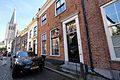
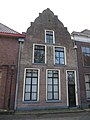
Category:Veerpoortstraat 19, Doesburg
Jump to navigation
Jump to search
| Object location | | View all coordinates using: OpenStreetMap |
|---|
building in Doesburg, Netherlands  | |||||
| Upload media | |||||
| Instance of | |||||
|---|---|---|---|---|---|
| Location | Doesburg, Gelderland, Netherlands | ||||
| Street address |
| ||||
| Located on street | |||||
| Heritage designation |
| ||||
 | |||||
|
This is a category about rijksmonument number 13066
|
| Address |
|
Media in category "Veerpoortstraat 19, Doesburg"
The following 8 files are in this category, out of 8 total.
-
 Doesburg, Netherlands - panoramio (32).jpg 2,048 × 1,375; 619 KB
-
 Doesburg, Netherlands - panoramio (70).jpg 4,896 × 3,264; 2.13 MB
-
 Doesburg, Netherlands - panoramio - Ben Bender (14).jpg 4,896 × 3,264; 2.76 MB
-
 Doesburg, Veerpoortstraat 19 matig.jpg 1,536 × 2,048; 849 KB
-
 Doesburg, Veerpoortstraat 19.jpg 1,536 × 2,048; 745 KB
-
 RM13066 Doesburg - Veerpoortstraat 19.jpg 1,944 × 2,592; 1.12 MB
-
 Voorgevel - Doesburg - 20058381 - RCE.jpg 805 × 1,200; 171 KB
-
 Zuid wand vanuit het westen - Doesburg - 20058364 - RCE.jpg 800 × 1,200; 179 KB
.jpg)
.jpg)
.jpg)


