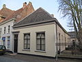
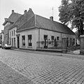
Category:Veerpoortstraat 18, Doesburg
Jump to navigation
Jump to search
| Object location | | View all coordinates using: OpenStreetMap |
|---|
house in Doesburg, Netherlands  | |||||
| Upload media | |||||
| Instance of | |||||
|---|---|---|---|---|---|
| Location | Doesburg, Gelderland, Netherlands | ||||
| Street address |
| ||||
| Located on street | |||||
| Heritage designation |
| ||||
 | |||||
|
This is a category about rijksmonument number 13070
|
| Address |
|
Media in category "Veerpoortstraat 18, Doesburg"
The following 9 files are in this category, out of 9 total.
-
 Doesburg, Netherlands - panoramio (131).jpg 2,048 × 1,155; 735 KB
-
 Doesburg, Netherlands - panoramio (25).jpg 2,048 × 1,375; 614 KB
-
 Doesburg, Netherlands - panoramio (68).jpg 4,896 × 3,264; 2.82 MB
-
 Doesburg, Netherlands - panoramio - Ben Bender (11).jpg 4,896 × 3,264; 3.91 MB
-
 Doesburg, Netherlands - panoramio - Ben Bender (12).jpg 4,896 × 3,264; 3.86 MB
-
 RM13070 Doesburg - Veerpoortstraat 18.jpg 2,592 × 1,944; 1.4 MB
-
 Van af naar het westen - Doesburg - 20058378 - RCE.jpg 1,200 × 1,200; 270 KB
-
 Voor- en rechter zijgevel - Doesburg - 20058380 - RCE.jpg 1,200 × 1,200; 344 KB
-
 Voor- en zijgevel - Doesburg - 20058379 - RCE.jpg 1,200 × 807; 178 KB
.jpg)
.jpg)
.jpg)
.jpg)
.jpg)


