Category:Van Houten Kerkje (Weesp)
Jump to navigation
Jump to search
| Object location | | View all coordinates using: OpenStreetMap |
|---|
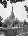
church building in Weesp, Netherlands  | |||||
| Upload media | |||||
| Instance of | |||||
|---|---|---|---|---|---|
| Part of | |||||
| Location | Weesp, Amsterdam, North Holland, Netherlands | ||||
| Street address |
| ||||
| Located on street |
| ||||
| Connects with | |||||
| Architect | |||||
| Heritage designation |
| ||||
| Inception |
| ||||
| Significant event |
| ||||
| Religion or worldview | |||||
 | |||||
|
This is a category about rijksmonument number 512906
|
Media in category "Van Houten Kerkje (Weesp)"
The following 10 files are in this category, out of 10 total.
-
 512906 Van Houten kerkje.jpg 3,388 × 4,517; 10.41 MB
-
 Achtergevel - Weesp - 20252556 - RCE.jpg 954 × 1,200; 233 KB
-
 Interieur - Weesp - 20252557 - RCE.jpg 950 × 1,200; 303 KB
-

-
 RM512906 Weesp - Oudegracht 69.jpg 2,352 × 3,152; 1.83 MB
-
 Van Houten Kerkje (Weesp).JPG 3,264 × 4,928; 5.94 MB
-
 Van Houtenkerk Plaat.jpg 2,890 × 2,167; 869 KB
-
 Voorgevel toren kerk - Weesp - 20252555 - RCE.jpg 960 × 1,200; 252 KB
-
 W - panoramio.jpg 2,000 × 3,008; 1.57 MB
-
 Weesp - panoramio - Rokus C (11).jpg 2,000 × 3,008; 1.46 MB


.JPG)


.jpg)