Category:Utah State Route 78 (1935-1969)
Jump to navigation
Jump to search
former state highway in Orem and Provo in Utah, United States   | |||||
| Upload media | |||||
| Instance of | |||||
|---|---|---|---|---|---|
| Location | |||||
| Transport network | |||||
| Owned by |
| ||||
| Maintained by |
| ||||
| Start time |
| ||||
| Dissolved, abolished or demolished date |
| ||||
| Length |
| ||||
| Terminus |
| ||||
| |||||
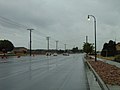
English: Media related to Utah State Route 78 (1935-1969), a former 1.6-mile (2.6 km) state highway in southeastern Orem and northern Provo in Utah, United States, that ran along East 800 South (Orem) and 3700 North (Provo) from Utah State Route 8 (U.S. Route 89/North State Street) in Orem to Utah State Route 7 (U.S. Route 189/North Canyon Road) in Provo.
When originally established in 1935, the route was 4.2 miles (6.8 km) long and began at Utah State Route 114 (Geneva Road), but the section west of State Street in Orem was deleted in 1953 in preparation for the construction of Interstate 15. In 1967, Utah State Route 7 (U.S. Route 189) was rerouted from Canyon Road west to North University Avenue, thus truncating the eastern end of the route by 0.4 miles (0.64 km).
When originally established in 1935, the route was 4.2 miles (6.8 km) long and began at Utah State Route 114 (Geneva Road), but the section west of State Street in Orem was deleted in 1953 in preparation for the construction of Interstate 15. In 1967, Utah State Route 7 (U.S. Route 189) was rerouted from Canyon Road west to North University Avenue, thus truncating the eastern end of the route by 0.4 miles (0.64 km).
Subcategories
This category has only the following subcategory.
Media in category "Utah State Route 78 (1935-1969)"
The following 13 files are in this category, out of 13 total.
-
 East at level crossing on W 800 S, Orem, Utah, Jun 16.jpg 2,592 × 1,944; 2.39 MB
-
 East at SR-114 & W 800 S intersection in Orem, Utah, Jun 16.jpg 2,592 × 1,944; 2.32 MB
-
 East at US-189 & E 3700 N in Provo, Utah, Jun 16.jpg 2,592 × 1,944; 2.39 MB
-
 North at SR-114 & W 800 S intersection in Orem, Utah, Jun 16.jpg 2,592 × 1,944; 2.35 MB
-
 North at US-189 & E 3700 N in Provo, Utah, Jun 16.jpg 2,592 × 1,944; 2.34 MB
-
 South at SR-114 & W 800 S intersection in Orem, Utah, Jun 16.jpg 2,592 × 1,944; 2.33 MB
-
 South at US-189 & E 3700 N in Provo, Utah, Jun 16.jpg 2,592 × 1,944; 2.37 MB
-
 Utah 78.svg 600 × 600; 12 KB
-
 Utah SR 78.svg 385 × 385; 9 KB
-
 West at SR-114 & W 800 S intersection in Orem, Utah, Jun 16.jpg 2,592 × 1,944; 2.35 MB
-
 West at US-189 & E 3700 N in Provo, Utah, Jun 16.jpg 2,592 × 1,944; 2.37 MB
-
 West on E 3700 N in Provo, Utah, Jun 16.jpg 2,592 × 1,944; 2.25 MB
-
 West on W 800 S in Orem, Utah, Jun 16.jpg 2,592 × 1,944; 2.35 MB


