Category:Utah State Route 293
Jump to navigation
Jump to search
 | number: | (two hundred ninety-three) |
|---|---|---|
| State highways in Utah: | 273 · 274 · 275 · 276 · 279 · 280 · 281 · 282 · 284 · 285 · 286 · 287 · 288 · 289 · 290 · 291 · 292 · 293 · 294 · 295 · 296 · 297 · 298 · 299 · 300 · 301 · 302 · 303 · 304 · 305 · 306 · 307 · 308 · 309 · 310 · 311 · 312 · 313 |
state highway in Salt Lake City, Utah, United States | |||||
| Upload media | |||||
| Instance of | |||||
|---|---|---|---|---|---|
| Location | Capitol Hill Historic District, Salt Lake City, Salt Lake County, Utah | ||||
| Transport network | |||||
| Connects with | |||||
| Owned by |
| ||||
| Maintained by |
| ||||
| Inception |
| ||||
| Length |
| ||||
 | |||||
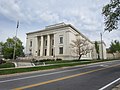
English: Media related to Utah State Route 293, the designation for the 1.1668 miles (1.8778 km) of roads and parking area at the state capitol building in north Salt Lake City, Utah, United States, and includes "all roads and parking areas within the capitol grounds".
Subcategories
This category has the following 2 subcategories, out of 2 total.
S
Media in category "Utah State Route 293"
The following 7 files are in this category, out of 7 total.
-
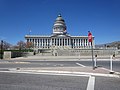 Salt Lake City, Utah (2021) - 014.jpg 4,000 × 3,000; 2.51 MB
-
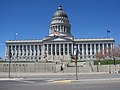 Salt Lake City, Utah (2021) - 015.jpg 4,000 × 3,000; 2.53 MB
-
 Salt Lake City, Utah (2021) - 311.jpg 4,000 × 3,000; 2.44 MB
-
 Salt Lake City, Utah (2021) - 321.jpg 4,000 × 3,000; 2.26 MB
-
 Utah 293.svg 750 × 600; 74 KB
-
 Utah SR 293.svg 385 × 385; 10 KB
-
 White Memorial Chapel (Salt Lake City)3.JPG 2,048 × 1,536; 1.58 MB
_-_014.jpg)
_-_015.jpg)
_-_311.jpg)
_-_321.jpg)

3.JPG)