Category:United States presidential election maps by electoral college vote (set)
Jump to navigation
Jump to search
This category is an image set. It should contain only images that have the same style, and should have a parent category that is purely topical.
This is a set category for nationwide electoral college result SVGs. This should only contain SVGs with consistent coloring and naming (conventions described at Commons:WikiProject Elections and Referendums/USA election map naming conventions).
Pages in category "United States presidential election maps by electoral college vote (set)"
This category contains only the following page.
Media in category "United States presidential election maps by electoral college vote (set)"
The following 62 files are in this category, out of 62 total.
-
 Electoral College 2028.svg 1,020 × 593; 32 KB
-
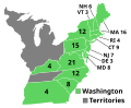
 ElectoralCollege1789.svg 542 × 446; 49 KB
-
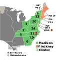
 ElectoralCollege1792.svg 542 × 446; 39 KB
-
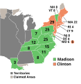
 ElectoralCollege1796.svg 542 × 446; 44 KB
-
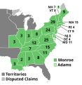
 ElectoralCollege1800.svg 542 × 446; 44 KB
-
 ElectoralCollege1804.svg 577 × 593; 121 KB
-
 ElectoralCollege1808.svg 577 × 593; 122 KB
-
 ElectoralCollege1812.svg 577 × 593; 118 KB
-
 ElectoralCollege1816.svg 577 × 593; 162 KB
-
 ElectoralCollege1820.svg 577 × 593; 170 KB
-
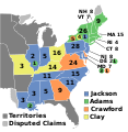 ElectoralCollege1824.svg 577 × 593; 190 KB
-
 ElectoralCollege1828.svg 577 × 593; 172 KB
-
 ElectoralCollege1832.svg 577 × 593; 172 KB
-
 ElectoralCollege1836.svg 577 × 593; 175 KB
-
 ElectoralCollege1840.svg 577 × 593; 167 KB
-
 ElectoralCollege1844.svg 577 × 593; 166 KB
-
 ElectoralCollege1848.svg 1,020 × 593; 170 KB
-
 ElectoralCollege1852.svg 1,020 × 593; 122 KB
-
 ElectoralCollege1856.svg 1,020 × 593; 85 KB
-
 ElectoralCollege1860.svg 1,020 × 593; 85 KB
-
 ElectoralCollege1864.svg 1,020 × 593; 69 KB
-
 ElectoralCollege1868.svg 1,020 × 593; 78 KB
-
 ElectoralCollege1872.svg 1,020 × 593; 80 KB
-
 ElectoralCollege1876.svg 1,020 × 593; 78 KB
-
 ElectoralCollege1880.svg 1,020 × 593; 79 KB
-
 ElectoralCollege1884.svg 1,020 × 593; 78 KB
-
 ElectoralCollege1888.svg 1,020 × 593; 80 KB
-
 ElectoralCollege1892.svg 1,020 × 593; 108 KB
-
 ElectoralCollege1896.svg 1,020 × 593; 25 KB
-
 ElectoralCollege1900.svg 1,020 × 593; 25 KB
-
 ElectoralCollege1904.svg 1,020 × 593; 25 KB
-
 ElectoralCollege1908.svg 989 × 572; 83 KB
-
 ElectoralCollege1912.svg 1,020 × 593; 25 KB
-
 ElectoralCollege1916.svg 1,020 × 593; 25 KB
-
 ElectoralCollege1920.svg 1,020 × 593; 25 KB
-
 ElectoralCollege1924.svg 1,020 × 593; 25 KB
-
 ElectoralCollege1928.svg 1,020 × 593; 25 KB
-
 ElectoralCollege1932.svg 1,020 × 593; 25 KB
-
 ElectoralCollege1936.svg 1,020 × 593; 25 KB
-
 ElectoralCollege1940.svg 1,020 × 593; 25 KB
-
 ElectoralCollege1944.svg 1,020 × 593; 25 KB
-
 ElectoralCollege1948.svg 1,020 × 593; 25 KB
-
 ElectoralCollege1952.svg 1,020 × 593; 25 KB
-
 ElectoralCollege1956.svg 1,020 × 593; 25 KB
-
 ElectoralCollege1960.svg 1,020 × 593; 29 KB
-
 ElectoralCollege1964.svg 1,020 × 593; 28 KB
-
 ElectoralCollege1968.svg 1,020 × 593; 29 KB
-
 ElectoralCollege1972.svg 1,020 × 593; 28 KB
-
 ElectoralCollege1976.svg 1,020 × 593; 29 KB
-
 ElectoralCollege1980.svg 1,020 × 593; 28 KB
-
 ElectoralCollege1984.svg 1,020 × 593; 28 KB
-
 ElectoralCollege1988.svg 1,020 × 593; 28 KB
-
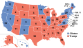
 ElectoralCollege1992.svg 1,020 × 593; 28 KB
-
 ElectoralCollege1996.svg 1,020 × 593; 28 KB
-
 ElectoralCollege2000.svg 1,020 × 593; 28 KB
-
 ElectoralCollege2004.svg 1,020 × 593; 29 KB
-
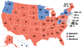
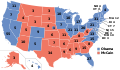 ElectoralCollege2008.svg 1,020 × 593; 29 KB
-
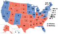 ElectoralCollege2012.svg 1,020 × 593; 29 KB
-
 ElectoralCollege2016(projected).svg 1,020 × 593; 29 KB
-
 ElectoralCollege2016.svg 1,020 × 593; 30 KB
-
 ElectoralCollege2020.svg 1,020 × 593; 29 KB
-
 ElectoralCollege2024.svg 1,020 × 593; 29 KB


.svg)


