Category:United Kingdom photographs taken on 2007-06-13
Jump to navigation
Jump to search
Countries of Europe: Austria · Belgium · Finland · France‡ · Germany · Greece · Hungary · Iceland · Republic of Ireland · Italy · Kazakhstan‡ · Luxembourg · Netherlands‡ · Norway · Poland · Russia‡ · Spain‡ · Sweden · Switzerland · Ukraine · United Kingdom
‡: partly located in Europe
‡: partly located in Europe
| ← | 13 June 2007 | → | ||
| ← | June 2007 | → | ||

United Kingdom photographs taken on 13 June 2007.
Image files should be categorized here automatically using {{taken on}} template. Direct categorisation is also possible, if automatic is impossible.
Subcategories
This category has the following 2 subcategories, out of 2 total.
L
S
Media in category "United Kingdom photographs taken on 2007-06-13"
The following 200 files are in this category, out of 433 total.
(previous page) (next page)-
 "Energy" on Fileys Coble Landing - geograph.org.uk - 469004.jpg 640 × 480; 60 KB
-
 'Lady' in red. - geograph.org.uk - 502849.jpg 428 × 640; 106 KB
-
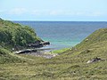
 A beach on South Uist - geograph.org.uk - 466399.jpg 640 × 418; 86 KB
-
 A bit of old Falmouth - geograph.org.uk - 691680.jpg 640 × 410; 76 KB
-
 A303 on edge of Andover - geograph.org.uk - 465872.jpg 640 × 425; 73 KB
-
 A3057 heading down to Cottonworth - geograph.org.uk - 468665.jpg 640 × 425; 86 KB
-
 A5, Kilburn High Road - geograph.org.uk - 479145.jpg 640 × 480; 106 KB
-
 Water tower and wheat field, Clay Lane - geograph.org.uk - 466980.jpg 640 × 480; 107 KB
-
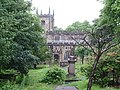
 Across the fields to church - geograph.org.uk - 465720.jpg 640 × 480; 108 KB
-
 All Saints Church, Chalbury - geograph.org.uk - 465801.jpg 640 × 480; 71 KB
-
 An Tuail, Colonsay - geograph.org.uk - 470740.jpg 640 × 480; 75 KB
-

-
-

-

-
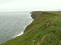
 Beach and cliffs at Highcliffe - geograph.org.uk - 469082.jpg 640 × 480; 68 KB
-
 Belfast Saab dealer Agnew - panoramio.jpg 2,592 × 1,944; 2.09 MB
-
 Belsize Road - geograph.org.uk - 467285.jpg 640 × 480; 87 KB
-
 Benenden Hospital from Green Lane - geograph.org.uk - 484174.jpg 640 × 427; 121 KB
-
 Black Gutter Bottom, New Forest - geograph.org.uk - 467907.jpg 640 × 427; 90 KB
-
 Black Gutter, New Forest - geograph.org.uk - 466240.jpg 640 × 427; 100 KB
-

-
 Boundary Road, NW8 - geograph.org.uk - 466960.jpg 640 × 480; 85 KB
-
 Bridleway beside the River Allen - geograph.org.uk - 466492.jpg 640 × 480; 135 KB
-

-
 Bridleway near Crichel Mill - geograph.org.uk - 466510.jpg 640 × 480; 92 KB
-
 Bull in field^ - geograph.org.uk - 465598.jpg 640 × 480; 103 KB
-

-
 Butcher Lane - geograph.org.uk - 482288.jpg 427 × 640; 62 KB
-
 Butterfly Orchid, Barra - geograph.org.uk - 654996.jpg 480 × 640; 47 KB
-
 Caister Water Tower - geograph.org.uk - 467246.jpg 640 × 425; 80 KB
-
 Canada Geese family at Drummonds Dub - geograph.org.uk - 465958.jpg 640 × 503; 402 KB
-
 Cemetery awaiting occupants - geograph.org.uk - 466012.jpg 640 × 480; 120 KB
-
 Church at Crossbost - geograph.org.uk - 465762.jpg 640 × 480; 40 KB
-
 Church at Leurbost - geograph.org.uk - 465758.jpg 640 × 480; 52 KB
-
 Church Lane, Oxted - geograph.org.uk - 479072.jpg 640 × 480; 104 KB
-
 Cleared area in Tyning Wood - geograph.org.uk - 466288.jpg 640 × 480; 139 KB
-

-
 Coble Landing Filey - geograph.org.uk - 468980.jpg 640 × 480; 70 KB
-

-
 Coire Lair path - geograph.org.uk - 1128034.jpg 640 × 480; 95 KB
-
 Lane to the Church - geograph.org.uk - 465693.jpg 640 × 427; 87 KB
-
 Cottages, Swindon Road, Stratton, Swindon - geograph.org.uk - 465580.jpg 640 × 480; 150 KB
-
 Creagorry Post Office - geograph.org.uk - 642117.jpg 640 × 480; 62 KB
-
 Crops and Trees - geograph.org.uk - 466543.jpg 640 × 427; 76 KB
-

-
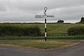 Crossroads sign - geograph.org.uk - 466404.jpg 640 × 427; 42 KB
-
 Cuaig - geograph.org.uk - 496559.jpg 640 × 480; 121 KB
-
 Cuaig Bay - geograph.org.uk - 496564.jpg 640 × 480; 86 KB
-
 Deane Parish Church.jpg 622 × 466; 205 KB
-
 Derelict house on the old A19 - geograph.org.uk - 465679.jpg 640 × 427; 77 KB
-

-
 Ditch and Water Forget-Me-Knot - geograph.org.uk - 466024.jpg 640 × 480; 144 KB
-
 East window - geograph.org.uk - 482264.jpg 427 × 640; 57 KB
-
 Eastgate - geograph.org.uk - 482267.jpg 640 × 427; 65 KB
-
 Eastgate view - geograph.org.uk - 482261.jpg 427 × 640; 60 KB
-
 Eden Roc, Hessle - geograph.org.uk - 466476.jpg 475 × 640; 119 KB
-
 Edimbourg The Unicorn of Scotland (2).jpg 891 × 1,507; 1.05 MB
-
 Edimbourg The Unicorn of Scotland.jpg 878 × 1,538; 385 KB
-
 Edinburgh The royal Mill (2).jpg 1,600 × 1,200; 1.68 MB
-
 Edinburgh The royal Mill.jpg 1,600 × 1,200; 2.18 MB
-
 Eilean Olmsa, Colonsay - geograph.org.uk - 470719.jpg 640 × 480; 85 KB
-
 Endsleigh Hotel - geograph.org.uk - 468013.jpg 600 × 412; 56 KB
-
 Falkirk wheel in Scotland.jpg 1,600 × 1,199; 710 KB
-
 Farfield Lane - geograph.org.uk - 466849.jpg 640 × 360; 60 KB
-
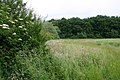 Field, Hedge and Woodland - geograph.org.uk - 466536.jpg 640 × 427; 116 KB
-
 Filey Beach looking to Coble Landing - geograph.org.uk - 468977.jpg 640 × 480; 56 KB
-
 Filey Sea Wall. - geograph.org.uk - 469009.jpg 640 × 480; 67 KB
-
 Flax - geograph.org.uk - 465995.jpg 640 × 427; 72 KB
-
 Footpath - geograph.org.uk - 468404.jpg 640 × 359; 71 KB
-
 Footpath and Track - geograph.org.uk - 466576.jpg 640 × 427; 100 KB
-
 Footpath and Track - geograph.org.uk - 466655.jpg 640 × 427; 94 KB
-
 Footpath^ - geograph.org.uk - 466553.jpg 640 × 427; 76 KB
-

-
 Funland on Coble Landing - geograph.org.uk - 469007.jpg 640 × 474; 80 KB
-
 Garland Ward, Benenden Hospital - geograph.org.uk - 484172.jpg 640 × 359; 59 KB
-
 Gate, and footpath through wheat - geograph.org.uk - 466069.jpg 640 × 480; 85 KB
-
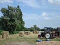
 Giant hay bales on Swains Farm - geograph.org.uk - 465993.jpg 640 × 480; 54 KB
-
 Goathland Station - geograph.org.uk - 1195045.jpg 640 × 414; 104 KB
-
 Golden Lion Hotel - geograph.org.uk - 465844.jpg 640 × 383; 38 KB
-
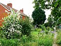
 Greenhill Cottage - geograph.org.uk - 466530.jpg 640 × 427; 112 KB
-
 Harbour Cruise Boats-Falmouth - geograph.org.uk - 742111.jpg 640 × 373; 50 KB
-
 Hartleton Water - geograph.org.uk - 465690.jpg 640 × 494; 463 KB
-
 Harvester Ant - geograph.org.uk - 467531.jpg 515 × 640; 214 KB
-
 Hay making at Denton Farm - geograph.org.uk - 467492.jpg 640 × 480; 92 KB
-
 Haymaking on hold - geograph.org.uk - 465714.jpg 640 × 427; 49 KB
-
 Headless woman - geograph.org.uk - 465760.jpg 640 × 480; 74 KB
-
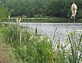
 Heron by the lake - geograph.org.uk - 465684.jpg 640 × 471; 445 KB
-
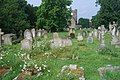
 Hessle Cemetery - geograph.org.uk - 466464.jpg 453 × 640; 123 KB
-
 Sundial and 17th century memorial stone - geograph.org.uk - 465994.jpg 640 × 480; 149 KB
-
 HMS Edinburgh Falklands.jpg 3,800 × 2,410; 5.98 MB
-
 HMS Edinburgh's Lynx Helicopter Opens Fire with her .50 Cal Machine Gun MOD 45150160.jpg 1,754 × 2,438; 1.34 MB
-
 Village sign and church, Holme - geograph.org.uk - 467485.jpg 640 × 480; 136 KB
-
 Home Guard memorial, River Ray, Blunsdon - geograph.org.uk - 465672.jpg 480 × 640; 137 KB
-
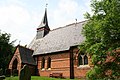
 St John the Evangelist, Hopwood - geograph.org.uk - 467275.jpg 632 × 474; 148 KB
-
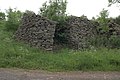
 House ruin with short chimneys - geograph.org.uk - 466371.jpg 640 × 426; 103 KB
-
 Water tower at Sapley - geograph.org.uk - 467376.jpg 640 × 480; 67 KB
-
 Hurstbourne Viaduct - geograph.org.uk - 608048.jpg 640 × 427; 109 KB
-
 Hôtel de ville d'Édimbourg.jpg 1,600 × 1,200; 920 KB
-

-
 Inverewe Gardens (33300902336).jpg 2,048 × 1,536; 750 KB
-
 Istanbul - geograph.org.uk - 482276.jpg 640 × 427; 77 KB
-
 Jenny Brough Lane, Hessle - geograph.org.uk - 466467.jpg 480 × 640; 123 KB
-
 Junction of B5500 and Pear Tree Lane - geograph.org.uk - 465793.jpg 640 × 480; 29 KB
-
 Kite Feeding Centre - geograph.org.uk - 1302086.jpg 640 × 480; 100 KB
-
 Little Butcher Lane - geograph.org.uk - 482295.jpg 427 × 640; 82 KB
-
 Little Cawthorpe Manor House - geograph.org.uk - 466033.jpg 640 × 427; 87 KB
-
 Llandanwg Halt.jpg 3,008 × 2,000; 2.79 MB
-
 Looking East from Greymore - geograph.org.uk - 465887.jpg 640 × 480; 51 KB
-

-
 Looking North-East from Greymore - geograph.org.uk - 465922.jpg 640 × 480; 53 KB
-
 Looking South-West from Greymore - geograph.org.uk - 465931.jpg 640 × 480; 85 KB
-
 Loverley Mill - geograph.org.uk - 466515.jpg 640 × 480; 130 KB
-
 Lynx Helicopter of HMS Edinburgh MOD 45148195.jpg 3,800 × 2,525; 6.19 MB
-
 Lynx Mk8 helicopter of HMS Edinburgh MOD 45148202.jpg 3,153 × 2,162; 5.23 MB
-
 Lynx Mk8 helicopter of HMS Edinburgh MOD 45148204.jpg 2,849 × 1,961; 4.38 MB
-
 M62 - geograph.org.uk - 467281.jpg 620 × 464; 162 KB
-
 M62 going east - geograph.org.uk - 467280.jpg 640 × 480; 145 KB
-
 Mallyan Spout, Goathland - geograph.org.uk - 1376189.jpg 427 × 640; 135 KB
-
 Manby tank - geograph.org.uk - 466026.jpg 640 × 427; 54 KB
-
 Maritime Festival 2007 - geograph.org.uk - 555349.jpg 640 × 482; 88 KB
-
 Market Clock (Detail), Wolverhampton - geograph.org.uk - 466013.jpg 640 × 481; 147 KB
-
 Market Day - geograph.org.uk - 482291.jpg 640 × 427; 86 KB
-
 Modern Housing in Rowthorne - geograph.org.uk - 468382.jpg 640 × 358; 71 KB
-
 More apartments^ - geograph.org.uk - 539973.jpg 528 × 640; 132 KB
-
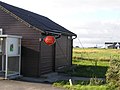
 New house in South Uist - geograph.org.uk - 940303.jpg 640 × 501; 88 KB
-

-

-
 North Cliff Country Park caravan site - geograph.org.uk - 468976.jpg 640 × 472; 62 KB
-
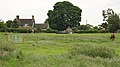
 North Reston farmland - geograph.org.uk - 465900.jpg 640 × 427; 60 KB
-
 Old car - geograph.org.uk - 465616.jpg 640 × 480; 94 KB
-
 Old station platform - geograph.org.uk - 466375.jpg 640 × 427; 71 KB
-
 Orasaigh.jpg 640 × 480; 55 KB
-
 Pen-y-ghent in the mist - geograph.org.uk - 465885.jpg 640 × 391; 19 KB
-
 Pigeon Post - geograph.org.uk - 465901.jpg 480 × 640; 96 KB
-
 Pond Cottage Endsleigh - geograph.org.uk - 468021.jpg 600 × 407; 52 KB
-
 Ponies on Deadman Hill, New Forest - geograph.org.uk - 467922.jpg 640 × 320; 60 KB
-
 Post box on Dark Lane - geograph.org.uk - 466508.jpg 640 × 471; 51 KB
-
 Postbox in Gorsley, near to Sugar Tump - geograph.org.uk - 465393.jpg 640 × 490; 372 KB
-
 Postbox in New Town - geograph.org.uk - 466211.jpg 640 × 602; 163 KB
-
 Priory Road - geograph.org.uk - 466967.jpg 640 × 480; 108 KB
-
 Public Footpath^ - geograph.org.uk - 466549.jpg 640 × 427; 79 KB
-
 Rectory Farm, Brampton Hut - geograph.org.uk - 467602.jpg 640 × 480; 104 KB
-
 Redundant Oil Jetty, Canvey Island - geograph.org.uk - 1031457.jpg 640 × 480; 47 KB
-
 River Allen near Crichel Mill - geograph.org.uk - 466502.jpg 640 × 480; 155 KB
-
 River Allen, Crichel Estate - geograph.org.uk - 466334.jpg 640 × 480; 132 KB
-
 Riverside Cottage - geograph.org.uk - 466652.jpg 640 × 427; 94 KB
-
 Rock art on sofa, June 2007 - geograph.org.uk - 1112583.jpg 640 × 480; 101 KB
-
 Rock in the forest - geograph.org.uk - 465998.jpg 640 × 480; 67 KB
-
 Rockart near Gardom's Edge - geograph.org.uk - 551476.jpg 640 × 480; 160 KB
-
 Rowthorne Lane - geograph.org.uk - 470205.jpg 640 × 360; 74 KB
-
 Rowthorne Lane - geograph.org.uk - 470209.jpg 640 × 360; 65 KB
-
 Rowthorne Lane - geograph.org.uk - 470220.jpg 640 × 360; 93 KB
-
 Rowthorne Lane - geograph.org.uk - 470911.jpg 640 × 360; 84 KB
-
 Ruined Clachan, Colonsay - geograph.org.uk - 470702.jpg 640 × 480; 77 KB
-
 Ruined lime kiln - geograph.org.uk - 465726.jpg 640 × 427; 83 KB
-
 Safety Notice - geograph.org.uk - 469013.jpg 640 × 480; 85 KB
-

-

-
 Shadwell Basin.jpg 3,399 × 2,094; 1.06 MB
-
 Slime mould - geograph.org.uk - 466077.jpg 640 × 480; 91 KB
-
 Soho Cottage - geograph.org.uk - 1129894.jpg 640 × 481; 103 KB
-
 Spruce tree, burial ground Oxted - geograph.org.uk - 479110.jpg 640 × 480; 149 KB
-
 St Mary's church, Llanfair-nant-y-gof - geograph.org.uk - 465990.jpg 640 × 480; 115 KB
-
 St Oswald's Church - Horton - geograph.org.uk - 465878.jpg 640 × 424; 42 KB
-
 St Peter and St Paul Church, Headcorn - geograph.org.uk - 484189.jpg 640 × 427; 102 KB
-
 St.Edith's church, North Reston - geograph.org.uk - 465891.jpg 640 × 427; 70 KB
-
 St.Helen's church - geograph.org.uk - 466042.jpg 640 × 427; 85 KB
-
 Farmhouse, Church Street, Stilton - geograph.org.uk - 467498.jpg 640 × 480; 80 KB
-
 Storm Debris - geograph.org.uk - 466346.jpg 640 × 442; 75 KB
-

-

-

-
 Tank - geograph.org.uk - 466023.jpg 640 × 427; 55 KB
-
 Teasdale Motorcycles - geograph.org.uk - 465675.jpg 640 × 427; 57 KB
-
 Thatched cottage in New Town - geograph.org.uk - 466231.jpg 640 × 480; 96 KB
-
 The Cannyreagh Road, Donaghadee (3) - geograph.org.uk - 465494.jpg 640 × 427; 95 KB
-

-

-
 The Cleveland Way looking to Filey - geograph.org.uk - 468963.jpg 640 × 480; 97 KB
-
-

-
 The Cock Tavern, Kilburn High Road - geograph.org.uk - 466950.jpg 480 × 640; 98 KB
-
 The Dairy Endsleigh Gardens - geograph.org.uk - 468031.jpg 600 × 450; 73 KB
-

-
 The ex Rotherhithe Police Station - geograph.org.uk - 1460605.jpg 640 × 480; 100 KB
-
 The Hidden Footbridge - geograph.org.uk - 466564.jpg 640 × 427; 155 KB
-
 The Horton Inn - geograph.org.uk - 465765.jpg 640 × 480; 56 KB
-

-
 The New Market Clock, Wolverhampton - geograph.org.uk - 466003.jpg 640 × 438; 150 KB
-
 The Northern approach to Helmsley - geograph.org.uk - 466383.jpg 640 × 427; 62 KB
-

-
 The Road to Pilsworth Fishery - geograph.org.uk - 467282.jpg 640 × 480; 106 KB
-
 The road to Snishival - geograph.org.uk - 467211.jpg 640 × 426; 51 KB
-
 The Swan public house, Old Weston - geograph.org.uk - 467558.jpg 640 × 480; 98 KB
-
 The Wade (with Landrover at low tide) - geograph.org.uk - 665199.jpg 640 × 480; 88 KB
-
 The White Hart - geograph.org.uk - 467279.jpg 640 × 480; 143 KB
-
 There is a Brook Here - geograph.org.uk - 466566.jpg 427 × 640; 148 KB
-
 Three Arrows - geograph.org.uk - 467283.jpg 640 × 480; 103 KB
-
 Town's Pit, Hessle - geograph.org.uk - 466471.jpg 459 × 640; 146 KB


_in_flower,_Black_Gutter_Bottom,_New_Forest_-_geograph.org.uk_-_466283.jpg)


.jpg)

.jpg)


.jpg)


,_Wolverhampton_-_geograph.org.uk_-_466013.jpg)


_-_geograph.org.uk_-_465494.jpg)


_-_geograph.org.uk_-_665199.jpg)


