Category:United Kingdom photographs taken on 2006-04-22
Jump to navigation
Jump to search
Countries of Europe: Austria · Belgium · Czech Republic · Denmark · Finland · France‡ · Germany · Greece · Hungary · Republic of Ireland · Italy · Latvia · Netherlands‡ · Poland · Portugal‡ · Russia‡ · Slovakia · Spain‡ · Sweden · Ukraine · United Kingdom
‡: partly located in Europe
‡: partly located in Europe
| ← | 22 April 2006 | → | ||
| ← | April 2006 | → | ||

United Kingdom photographs taken on 22 April 2006.
Image files should be categorized here automatically using {{taken on}} template. Direct categorisation is also possible, if automatic is impossible.
Subcategories
This category has only the following subcategory.
S
Media in category "United Kingdom photographs taken on 2006-04-22"
The following 200 files are in this category, out of 750 total.
(previous page) (next page)-
 14632 Hull - Flickr - megabus13601.jpg 2,048 × 1,536; 1,003 KB
-
 A Country Lane - geograph.org.uk - 157329.jpg 640 × 427; 108 KB
-

-
 A19 road bridge over the River Wear - geograph.org.uk - 165066.jpg 640 × 480; 44 KB
-
 A41 Langley Bypass - geograph.org.uk - 156572.jpg 640 × 480; 96 KB
-
 A41 Langley Bypass - geograph.org.uk - 156652.jpg 640 × 480; 107 KB
-
 Abbey Wall, St Andrews - geograph.org.uk - 157000.jpg 640 × 426; 265 KB
-
 Across the estuary to Eskmeals - geograph.org.uk - 156835.jpg 640 × 480; 21 KB
-
 Across the estuary towards Saltcoats - geograph.org.uk - 156839.jpg 640 × 480; 28 KB
-
 Across the Valley - geograph.org.uk - 156997.jpg 640 × 480; 351 KB
-
 Afon Marchlyn Mawr - geograph.org.uk - 223790.jpg 640 × 480; 77 KB
-
 Alexandra Close - geograph.org.uk - 157016.jpg 640 × 480; 118 KB
-
 All Saints Churchyard - geograph.org.uk - 160061.jpg 640 × 480; 134 KB
-

-
 All Saints, High Kelling, Norfolk - geograph.org.uk - 320401.jpg 640 × 430; 139 KB
-
 All Saints, Oxwick, Norfolk - Ruin - geograph.org.uk - 320419.jpg 640 × 480; 172 KB
-
 All Saints, Oxwick, Norfolk - Ruin - geograph.org.uk - 320420.jpg 640 × 480; 169 KB
-
 All Saints, Oxwick, Norfolk - Ruin - geograph.org.uk - 320421.jpg 480 × 640; 147 KB
-

-
 Altruighe in spring - geograph.org.uk - 157512.jpg 640 × 479; 119 KB
-

-
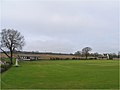
 Antenna and cricket pavilion - geograph.org.uk - 160366.jpg 640 × 480; 50 KB
-
 Anything to post^ - geograph.org.uk - 156857.jpg 640 × 480; 98 KB
-
 Approaching the Summit of Y Fronllwyd - geograph.org.uk - 223806.jpg 480 × 640; 70 KB
-
 Arrow Valley Lake, Redditch - geograph.org.uk - 156842.jpg 640 × 480; 275 KB
-
 Ashford Park - geograph.org.uk - 156979.jpg 640 × 480; 60 KB
-
 Ashford Park - geograph.org.uk - 160079.jpg 640 × 480; 135 KB
-
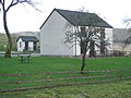
 Barn and Goods van, Mundham - geograph.org.uk - 156728.jpg 640 × 480; 114 KB
-
 Barn conversion, Kingstone Farmhouse - geograph.org.uk - 157137.jpg 640 × 480; 100 KB
-
 Barnard Castle - geograph.org.uk - 1254069.jpg 640 × 480; 77 KB
-
 Barrhead Fire Station - geograph.org.uk - 156884.jpg 640 × 480; 136 KB
-
 BBC Wales mobile studio - geograph.org.uk - 171944.jpg 640 × 480; 98 KB
-
 Beach and sandunes at Drigg. - geograph.org.uk - 156829.jpg 640 × 409; 30 KB
-
 Beach at Drigg Point. - geograph.org.uk - 156831.jpg 640 × 430; 22 KB
-
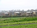
 BedZED tulips.jpg 2,560 × 1,920; 739 KB
-
 BedZED tulips2.jpg 2,560 × 1,920; 747 KB
-
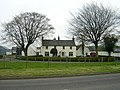
 Belsize, Flaunden Lane - geograph.org.uk - 156587.jpg 640 × 480; 148 KB
-
 Beoley Garage - geograph.org.uk - 159266.jpg 640 × 480; 253 KB
-
 Bergh Apton Village Hall - geograph.org.uk - 156605.jpg 640 × 480; 107 KB
-
 Beyond the Boundary Rope - geograph.org.uk - 156702.jpg 640 × 480; 95 KB
-
 Bickenhall.jpg 640 × 480; 81 KB
-
 Birley Edge - geograph.org.uk - 156734.jpg 640 × 480; 151 KB
-
 Blackbyres Farm, Barrhead - geograph.org.uk - 156867.jpg 640 × 480; 171 KB
-
 Blacksmith's Lane - geograph.org.uk - 160021.jpg 640 × 480; 121 KB
-
 Blacksmith's Lane - geograph.org.uk - 160022.jpg 640 × 480; 120 KB
-
 Blockfield on Y Fronllwyd - geograph.org.uk - 223805.jpg 640 × 480; 126 KB
-

-
 Book and Candle - geograph.org.uk - 159679.jpg 640 × 480; 305 KB
-
 Bough Beech Railway Arch - geograph.org.uk - 160096.jpg 640 × 480; 164 KB
-
 Boulder on Ingleborough Common - geograph.org.uk - 157297.jpg 640 × 480; 137 KB
-
 Brentford canal basin - geograph.org.uk - 582742.jpg 640 × 480; 93 KB
-
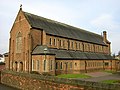
 Bretby Church - geograph.org.uk - 156896.jpg 640 × 426; 126 KB
-
 Bridge at Amulree - geograph.org.uk - 157424.jpg 640 × 480; 196 KB
-
 Bridge on the road to Brunant, Glanaman - geograph.org.uk - 959304.jpg 480 × 640; 145 KB
-
 Bridleway below Dunfell Hush - geograph.org.uk - 159114.jpg 640 × 480; 122 KB
-
 Bridleway by Ingsbury Cottage - geograph.org.uk - 156957.jpg 640 × 426; 109 KB
-
 Brock Burn - geograph.org.uk - 156725.jpg 640 × 480; 158 KB
-
 Brock Burn - geograph.org.uk - 156732.jpg 640 × 480; 217 KB
-
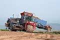 Brompton Ralph, beet crop harvester - geograph.org.uk - 157049.jpg 640 × 427; 123 KB
-
 Brompton Ralph, swede crop - geograph.org.uk - 157044.jpg 640 × 427; 143 KB
-
 Burial Chamber - geograph.org.uk - 156861.jpg 640 × 480; 489 KB
-
 Burn and Gorse - geograph.org.uk - 156754.jpg 640 × 480; 167 KB
-
 Busted Bus and United Free - geograph.org.uk - 157046.jpg 640 × 426; 108 KB
-
 Busway, Church Hill - geograph.org.uk - 159684.jpg 640 × 480; 320 KB
-
 Cairn and wonky stone, Stake Beck - geograph.org.uk - 159079.jpg 640 × 480; 102 KB
-
 Cairn on the Summit of Cox Tor - geograph.org.uk - 157553.jpg 640 × 427; 88 KB
-
 Campsite by the River Tavy - geograph.org.uk - 157690.jpg 640 × 427; 112 KB
-
 Canoeist leaving Porth Dafarch - geograph.org.uk - 158826.jpg 640 × 480; 62 KB
-

-
 Carpenter's Hill - geograph.org.uk - 157123.jpg 639 × 477; 314 KB
-
 Cattle in Glen Quaich - geograph.org.uk - 157442.jpg 640 × 480; 136 KB
-
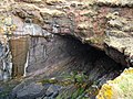 Cave at Siccar Point - geograph.org.uk - 157054.jpg 640 × 480; 123 KB
-
 Chapel at Lower Chapel - geograph.org.uk - 157664.jpg 640 × 480; 170 KB
-
 Cherry Pit Lane - geograph.org.uk - 159281.jpg 640 × 480; 414 KB
-

-

-
 Chipperfield, Croft Meadow - geograph.org.uk - 156583.jpg 640 × 480; 113 KB
-
 Church at Llanwrda - geograph.org.uk - 157517.jpg 640 × 480; 139 KB
-
 Church Farm, Little Birch - geograph.org.uk - 158324.jpg 640 × 426; 103 KB
-
 Church Hill centre, Redditch - geograph.org.uk - 156838.jpg 640 × 480; 263 KB
-
 Church northwest of Beulah - geograph.org.uk - 157285.jpg 640 × 480; 171 KB
-
 Church of St Nicholas, Gunby - geograph.org.uk - 156792.jpg 640 × 480; 83 KB
-
 Church on Peat Road, Priesthill - geograph.org.uk - 156738.jpg 640 × 480; 187 KB
-
 Church Road, Ashford - geograph.org.uk - 156989.jpg 640 × 480; 94 KB
-
 Chwarel y Penrhyn from Y Fronllwyd - geograph.org.uk - 219447.jpg 640 × 480; 101 KB
-

-
 Clapham goods yard - geograph.org.uk - 157332.jpg 640 × 480; 131 KB
-
 Clifton Moor - geograph.org.uk - 156815.jpg 640 × 479; 90 KB
-
 Coastline North of Glengarrisdale Bay - geograph.org.uk - 869412.jpg 640 × 480; 58 KB
-
 Collaton - geograph.org.uk - 157359.jpg 640 × 427; 83 KB
-
 Collaton Lane - geograph.org.uk - 157362.jpg 640 × 427; 123 KB
-
-
 Crannog in Loch Freuchie - geograph.org.uk - 160168.jpg 480 × 640; 57 KB
-
 Currick, Nine Wells Sike - geograph.org.uk - 159059.jpg 640 × 480; 98 KB
-
 Cycleway and Footpath, Blackmarstone - geograph.org.uk - 157008.jpg 640 × 426; 100 KB
-

-
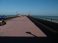 Deal Pier - geograph.org.uk - 347639.jpg 640 × 480; 49 KB
-
 Dereliction - geograph.org.uk - 156818.jpg 640 × 427; 113 KB
-
 Dinedor Church - geograph.org.uk - 157952.jpg 640 × 426; 119 KB
-
 Disused garage kiosk at Amulree - geograph.org.uk - 157503.jpg 480 × 640; 81 KB
-
 Disused railway cycleway, Donyatt - geograph.org.uk - 156980.jpg 640 × 480; 135 KB
-
 DownMillHill2.jpg 800 × 465; 377 KB
-
 Drigg beach. - geograph.org.uk - 156852.jpg 640 × 456; 16 KB
-
 Drover's Arms Inn on Epynt mountain - geograph.org.uk - 157616.jpg 640 × 480; 139 KB
-
 Dumphouse Lane - geograph.org.uk - 159761.jpg 640 × 480; 354 KB
-
 Dyke and Trig Point - geograph.org.uk - 156773.jpg 640 × 480; 99 KB
-
 Earthworks at Dinedor - geograph.org.uk - 159933.jpg 640 × 426; 107 KB
-
 St Mary's Church Eastwell - geograph.org.uk - 941782.jpg 640 × 480; 96 KB
-
 St Edmund's Church, Edmondbyers - geograph.org.uk - 157156.jpg 640 × 480; 99 KB
-
 Egglestone Abbey - geograph.org.uk - 1254039.jpg 640 × 480; 97 KB
-
 Elston Hall Primary School - geograph.org.uk - 156862.jpg 640 × 480; 94 KB
-
 Entrance to Lion Wood Nature reserve - geograph.org.uk - 159256.jpg 640 × 480; 431 KB
-
 Epynt Way - geograph.org.uk - 157640.jpg 480 × 640; 125 KB
-
 Estuary at Ravenglass. - geograph.org.uk - 156836.jpg 640 × 480; 27 KB
-
 Fake tanks on Sennybridge artillery range - geograph.org.uk - 157629.jpg 640 × 480; 148 KB
-
 Farmland - geograph.org.uk - 156948.jpg 640 × 480; 48 KB
-
 Field - geograph.org.uk - 156941.jpg 640 × 480; 67 KB
-
 Field near Idsworth - geograph.org.uk - 416427.jpg 480 × 640; 111 KB
-
 Field Vole (Microtus Agrestis) - geograph.org.uk - 167666.jpg 640 × 480; 122 KB
-
 Fields down to the River Tavy - geograph.org.uk - 157668.jpg 640 × 427; 119 KB
-

-
 Fishing - geograph.org.uk - 160082.jpg 640 × 480; 142 KB
-
 Five-way junction at Cefn Glancamddwr - geograph.org.uk - 157549.jpg 640 × 480; 126 KB
-
 Footbridge over a Dartmoor Stream - geograph.org.uk - 157593.jpg 427 × 640; 159 KB
-
 Footbridge over the River Tavy - geograph.org.uk - 157639.jpg 640 × 427; 148 KB
-
 Footpath - Riding Lane Hildenborough - geograph.org.uk - 156994.jpg 640 × 480; 193 KB
-

-
 Footpath near Waltham on the Wolds - geograph.org.uk - 157152.jpg 640 × 427; 96 KB
-
 Footpath through Greno Wood - geograph.org.uk - 156698.jpg 640 × 480; 277 KB
-
 Footpath to Rowney Green - geograph.org.uk - 159764.jpg 640 × 480; 284 KB
-
 Footpaths from the Car Park - geograph.org.uk - 157402.jpg 427 × 640; 103 KB
-
 Forest park - panoramio.jpg 2,048 × 1,536; 658 KB
-
 Formal Garden at Lanhydrock - geograph.org.uk - 1212725.jpg 480 × 640; 195 KB
-
 Former Council Depot - geograph.org.uk - 165174.jpg 640 × 480; 75 KB
-
 Former Garden Pond and Fountain - geograph.org.uk - 158150.jpg 640 × 480; 82 KB
-
 Former Quarry and Tip - geograph.org.uk - 158146.jpg 640 × 480; 56 KB
-
 FrindsburyChurchGreenChatZoom.JPG 2,848 × 2,136; 1.57 MB
-
 Garden at Newstead Abbey - panoramio - PJMarriott.jpg 2,048 × 1,536; 713 KB
-
 Garden at Newstead Abbey - panoramio.jpg 2,048 × 1,536; 816 KB
-
 Gardin, Vidlin, Shetland - geograph.org.uk - 157825.jpg 640 × 480; 46 KB
-
 Garth (Powys) Railway Station.jpg 640 × 480; 130 KB
-
 Garth Mill - geograph.org.uk - 157583.jpg 640 × 480; 118 KB
-
 Gatherstone Beck - geograph.org.uk - 156715.jpg 480 × 640; 91 KB
-
 Gibside Chapel - geograph.org.uk - 1254079.jpg 640 × 480; 71 KB
-
 Gibside Hall - geograph.org.uk - 1254085.jpg 640 × 480; 71 KB
-
 Gibside Monument - geograph.org.uk - 1254088.jpg 640 × 480; 48 KB
-
 Glebe Farm, Dinedor - geograph.org.uk - 157960.jpg 640 × 426; 148 KB
-
 Glen Quaich - geograph.org.uk - 157521.jpg 640 × 479; 108 KB
-
 Goodyear Factory from the A449 - geograph.org.uk - 156876.jpg 480 × 640; 94 KB
-
 Gordon Anstis House, Redditch - geograph.org.uk - 159671.jpg 640 × 480; 300 KB
-
 Gorge above Turrerich - geograph.org.uk - 157455.jpg 640 × 480; 167 KB
-
 Grand bridge over humble ditch - geograph.org.uk - 160375.jpg 640 × 480; 66 KB
-

-
 Grand Union Canal, at Hemel Hempstead - geograph.org.uk - 156638.jpg 640 × 480; 68 KB
-
 Grand Union Canal, Boxmoor Bottom Lock - geograph.org.uk - 156627.jpg 640 × 480; 119 KB
-
 Great Combe Tor - geograph.org.uk - 157576.jpg 640 × 427; 111 KB
-

-
 Grenoside Crematorium - geograph.org.uk - 156694.jpg 640 × 480; 171 KB
-
 Grieg Street footbridge.jpg 640 × 480; 94 KB
-
 Half way through No Man's Land - geograph.org.uk - 157622.jpg 640 × 480; 111 KB
-
 Halfway there - geograph.org.uk - 386606.jpg 640 × 480; 61 KB
-
 Ham House - geograph.org.uk - 587473.jpg 640 × 480; 84 KB
-
 Hampton Bishop Church - geograph.org.uk - 159938.jpg 426 × 640; 103 KB
-
 Hampton Bishop Village Hall - geograph.org.uk - 159939.jpg 640 × 426; 81 KB
-
 Harryhorse Stone - geograph.org.uk - 157253.jpg 640 × 480; 107 KB
-
 Harryhorse Stone^ - geograph.org.uk - 157255.jpg 640 × 480; 114 KB
-
 Heading for Carnedd y Filiast - geograph.org.uk - 223808.jpg 640 × 480; 60 KB
-
 High Elms - geograph.org.uk - 160017.jpg 640 × 480; 116 KB
-
 High Sheep Pasture west of Dartmoor - geograph.org.uk - 157568.jpg 640 × 427; 127 KB
-

-
 Higham Lake Trout Fishery - geograph.org.uk - 156801.jpg 640 × 480; 158 KB
-
 Higher Shelf Stones - geograph.org.uk - 157314.jpg 640 × 480; 91 KB
-

-

-
 Holkham Hall Park, Norfolk - geograph.org.uk - 320396.jpg 640 × 480; 138 KB
-
 Holme Lacy Road, Hereford - geograph.org.uk - 157015.jpg 640 × 426; 86 KB
-
 Holyhead Maritime Museum - geograph.org.uk - 386599.jpg 640 × 480; 56 KB
-
 Holyhead Maritime Museum - geograph.org.uk - 386614.jpg 640 × 480; 71 KB
-
 House at Ffrwd-wen on Epynt mountain - geograph.org.uk - 157607.jpg 640 × 480; 219 KB
-
 Househill Parks Depot - geograph.org.uk - 156745.jpg 640 × 480; 168 KB
-
 How far to go^ - geograph.org.uk - 156832.jpg 640 × 480; 133 KB
-
 Humford Mill - geograph.org.uk - 157179.jpg 640 × 480; 110 KB
-
 Hutton's Unconformity, Siccar Point - geograph.org.uk - 157014.jpg 640 × 480; 131 KB
-
 I know what this is for - geograph.org.uk - 157085.jpg 640 × 480; 163 KB
-
 In Stathern Wood - geograph.org.uk - 156756.jpg 640 × 427; 221 KB
-
 Intake Channel - geograph.org.uk - 157027.jpg 640 × 480; 75 KB
-
 Inveraray 1 - panoramio.jpg 2,048 × 1,536; 573 KB
-
 Inveraray 2 - panoramio.jpg 2,048 × 1,536; 576 KB
-

-
 Isleworth - geograph.org.uk - 582736.jpg 640 × 480; 73 KB
-
 Itchen Valley Country Park recreation field.jpg 640 × 480; 65 KB
-
 Itchen Valley Country Park visitor centre.jpg 640 × 480; 74 KB
-
 Itchen Valley Country Park woodland trail.jpg 640 × 480; 103 KB
-
 Kilmorack Church - geograph.org.uk - 156897.jpg 640 × 480; 117 KB
-
 Kingford Farm - geograph.org.uk - 157326.jpg 640 × 427; 101 KB
-
 Kingstone church from the south - geograph.org.uk - 157143.jpg 480 × 640; 117 KB
-
 Knock Ore Gill - geograph.org.uk - 158355.jpg 640 × 480; 80 KB
-
 Lady Kirk, Sanday, Orkney - geograph.org.uk - 220173.jpg 640 × 428; 77 KB
-
 Lahill Craig farm - geograph.org.uk - 156682.jpg 640 × 480; 55 KB
-
 Lahill Mains cottage - geograph.org.uk - 156685.jpg 640 × 480; 54 KB


_Chariot_by_Westminster_Bridge_-_geograph.org.uk_-_259570.jpg)


_-_geograph.org.uk_-_167666.jpg)


_Railway_Station.jpg)


