Category:United Kingdom photographs taken on 2004-04-14
Jump to navigation
Jump to search
Countries of Europe: Belgium · France‡ · Germany · Greece · Republic of Ireland · Italy · Malta · Netherlands‡ · Portugal‡ · Russia‡ · Spain‡ · United Kingdom
‡: partly located in Europe
‡: partly located in Europe
| ← | 14 April 2004 | → | ||
| ← | April 2004 | → | ||

United Kingdom photographs taken on 14 April 2004.
Image files should be categorized here automatically using {{taken on}} template. Direct categorisation is also possible, if automatic is impossible.
Media in category "United Kingdom photographs taken on 2004-04-14"
The following 91 files are in this category, out of 91 total.
-
 "Rough masonry" - Tantallon Castle - geograph.org.uk - 46758.jpg 640 × 480; 127 KB
-
 Abandoned lime kilns near Trefil - geograph.org.uk - 83879.jpg 640 × 480; 93 KB
-
 Archway, Peterborough - geograph.org.uk - 468425.jpg 480 × 640; 85 KB
-
 Arnold, Nottinghamshire - geograph.org.uk - 32042.jpg 640 × 480; 137 KB
-
 Barge on the Grand Union Canal - geograph.org.uk - 1189977.jpg 640 × 464; 81 KB
-
 Barry Docks - geograph.org.uk - 22009.jpg 640 × 512; 129 KB
-
 Bass Rock from Tantallon Castle.jpg 480 × 640; 29 KB
-
 Bass Rock Tantallon Castle.jpg 640 × 480; 32 KB
-
 Bourton-on-the-Water - geograph.org.uk - 138688.jpg 640 × 480; 126 KB
-
 Burnsall Bridge looking north east - geograph.org.uk - 429621.jpg 640 × 480; 47 KB
-
 Carlton Bank Summit - geograph.org.uk - 12964.jpg 640 × 374; 32 KB
-
 Cathedral Square, Peterborough - geograph.org.uk - 468407.jpg 640 × 480; 84 KB
-

-
 Chillesford Church - geograph.org.uk - 84423.jpg 640 × 480; 85 KB
-
-
 Cwm Hirnant from Goel Goch - geograph.org.uk - 647080.jpg 640 × 480; 72 KB
-

-
 Doocot at Tantallon Castle - geograph.org.uk - 46759.jpg 640 × 480; 88 KB
-
 Drake Howe - geograph.org.uk - 862337.jpg 640 × 480; 64 KB
-
 Dun Troddan broch - geograph.org.uk - 741836.jpg 640 × 480; 106 KB
-
 Father Thames Statue - geograph.org.uk - 97657.jpg 640 × 480; 100 KB
-
 Felled area, Greenhow Plantation - geograph.org.uk - 862330.jpg 640 × 480; 74 KB
-
 Foel Cwm Sian Llwyd from Cyrniau Nod - geograph.org.uk - 647878.jpg 640 × 480; 80 KB
-
 Foel Goch summit - geograph.org.uk - 647069.jpg 640 × 480; 82 KB
-
 Foel y Geifr - geograph.org.uk - 647852.jpg 640 × 480; 63 KB
-

-
 Grouse grit on Round Hill - geograph.org.uk - 862323.jpg 640 × 393; 61 KB
-
 Grouse on Urra Moor. - geograph.org.uk - 12957.jpg 640 × 413; 106 KB
-
 Harewood House - geograph.org.uk - 252613.jpg 640 × 480; 93 KB
-
 Kintraw Standing Stone looking SW - geograph.org.uk - 2232.jpg 480 × 640; 29 KB
-
 Low Force - geograph.org.uk - 2694.jpg 480 × 640; 125 KB
-
 Maize Beck - geograph.org.uk - 2683.jpg 640 × 480; 80 KB
-
 Marwell Zoo Station - geograph.org.uk - 1115.jpg 640 × 480; 55 KB
-
 No Trains passing today - geograph.org.uk - 354139.jpg 640 × 422; 128 KB
-
 Number 2 Dunstone Cottages - geograph.org.uk - 1466337.jpg 640 × 480; 112 KB
-
 Party Fire Engine in Bathgate 14-04-2004. - panoramio.jpg 1,280 × 960; 463 KB
-
 Path junction on the Carr Ridge - geograph.org.uk - 862319.jpg 640 × 393; 46 KB
-
 Path on Cringle Moor - geograph.org.uk - 862334.jpg 639 × 384; 47 KB
-
 Paved path, Cringle Moor - geograph.org.uk - 862336.jpg 640 × 480; 55 KB
-
 Railway viaduct - geograph.org.uk - 38674.jpg 640 × 476; 114 KB
-
 Red means "DON'T CROSS" - geograph.org.uk - 354147.jpg 426 × 640; 140 KB
-
 Richmond Park (near Bog Lodge) - geograph.org.uk - 1664.jpg 640 × 480; 64 KB
-
 River Thames at Lechlade - geograph.org.uk - 97660.jpg 640 × 480; 61 KB
-
 Road near Trefil Quarries - geograph.org.uk - 83873.jpg 640 × 480; 43 KB
-
 Scarp slope of Urra Moor - geograph.org.uk - 862325.jpg 640 × 480; 57 KB
-
 Snail Mail - Capel St Andrew - geograph.org.uk - 84422.jpg 640 × 480; 75 KB
-
 Stone sign marking Bryn Oer Tramroad - geograph.org.uk - 83603.jpg 640 × 480; 132 KB
-
 Tantallon Castle - geograph.org.uk - 46763.jpg 480 × 640; 114 KB
-
 Temple Newsam Hall - panoramio - PJMarriott (1).jpg 2,048 × 1,536; 711 KB
-
 Temple Newsam Hall - panoramio - PJMarriott (2).jpg 1,536 × 2,048; 964 KB
-
 Temple Newsam Hall - panoramio - PJMarriott (3).jpg 2,048 × 1,536; 764 KB
-
 Temple Newsam Hall - panoramio - PJMarriott.jpg 1,536 × 2,048; 856 KB
-
 Temple Newsam Hall - panoramio.jpg 2,048 × 1,536; 766 KB
-
 Thatched cottage, Great Tew - geograph.org.uk - 138697.jpg 640 × 480; 110 KB
-

-

-

-
 The N Promenade at Oban - geograph.org.uk - 3523.jpg 640 × 480; 40 KB
-
 The Street, Butley - geograph.org.uk - 84420.jpg 640 × 480; 78 KB
-
 The Town Hall, Peterborough - geograph.org.uk - 468431.jpg 640 × 480; 91 KB
-
 Top of the Gorge - geograph.org.uk - 16124.jpg 426 × 640; 120 KB
-
 Trackbed of the Bryn Oer Tramroad - geograph.org.uk - 83872.jpg 640 × 480; 116 KB
-
 Turbine pump, Sutton Poyntz - geograph.org.uk - 1424225.jpg 415 × 640; 75 KB
-
 View indicator, Cringle Moor - geograph.org.uk - 862335.jpg 640 × 480; 93 KB
-

-
 View of Teign valley from hut circles - geograph.org.uk - 105406.jpg 640 × 480; 78 KB
-
 Waterfall in spate near Glenelg - geograph.org.uk - 545348.jpg 480 × 640; 116 KB
-
 Waverley St Fire engine. - panoramio.jpg 1,280 × 960; 463 KB
-
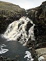
 White Lady Falls in Lydford Gorge - geograph.org.uk - 16122.jpg 427 × 640; 124 KB
-
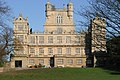 Wollaton Hall - geograph.org.uk - 11651.jpg 640 × 427; 126 KB
-
-
 Arch Hill, Red Hill, Arnold - geograph.org.uk - 34203.jpg 640 × 480; 105 KB
-
 Butley High Corner - geograph.org.uk - 84421.jpg 640 × 480; 90 KB
-
 Cauldron Snout - geograph.org.uk - 2686.jpg 480 × 640; 115 KB
-
 Cleveland Way on Urra Moor. - geograph.org.uk - 12958.jpg 640 × 400; 51 KB
-
 Cringle Moor from Lord's Stones. - geograph.org.uk - 12962.jpg 640 × 253; 40 KB
-
 Cringle Moor scarp. - geograph.org.uk - 12960.jpg 640 × 429; 86 KB
-
 Cronkley - geograph.org.uk - 2690.jpg 640 × 480; 105 KB
-
-
 Farm in Dyffryn Crawnon - geograph.org.uk - 83875.jpg 640 × 480; 71 KB
-
 Gleann Beag from Dun Troddan - geograph.org.uk - 741835.jpg 640 × 480; 76 KB
-

-
 Ogmore Castle - geograph.org.uk - 20635.jpg 640 × 512; 96 KB
-
 Old Spot Public House - geograph.org.uk - 34690.jpg 640 × 480; 113 KB
-
 Paddley Water near Chillesford - geograph.org.uk - 84424.jpg 640 × 480; 69 KB
-
 Path restoration, Carlton Bank. - geograph.org.uk - 12963.jpg 640 × 480; 101 KB
-
 Pen Rhiw Caich - geograph.org.uk - 83785.jpg 640 × 480; 63 KB
-
 Plantations on Cringle Moor. - geograph.org.uk - 12961.jpg 640 × 480; 98 KB
-
 Road below Tor-y-foel - geograph.org.uk - 83878.jpg 640 × 480; 44 KB
-
 Round Hill - geograph.org.uk - 12959.jpg 640 × 420; 43 KB
-
 Stile above Duffyrn Crawnon - geograph.org.uk - 83874.jpg 640 × 480; 64 KB


_-_geograph.org.uk_-_1664.jpg)


.jpg)
.jpg)
.jpg)


