Category:US National Archives series: World War II Records, ca. 1941 - ca. 1947
Jump to navigation
Jump to search
Subcategories
This category has only the following subcategory.
Media in category "US National Archives series: World War II Records, ca. 1941 - ca. 1947"
The following 25 files are in this category, out of 25 total.
-
-
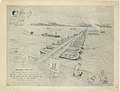
 1st Army Ordnance Installations 31 August 1944 - 1 September 1944 - NARA - 100384819.jpg 10,239 × 6,272; 10.41 MB
-

-
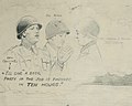
 General Pays Off - NARA - 12007749.jpg 8,736 × 6,623; 9.03 MB
-
 Japan Electric Power Map No. 4 - DPLA - d90590a33ec2bbbb9f253814e5821a0e.jpg 8,474 × 6,600; 8.09 MB
-
 Japan Electric Power Map No. 6 - DPLA - 58b0aa0b5529bd7f93eba77470fd67dd.jpg 8,461 × 6,600; 9.39 MB
-
 Map of Minefield - Houfalize - DPLA - 55bcfb6a4d3427b53148a04cd3ff3404.jpg 8,752 × 6,608; 5.14 MB
-
 Map of Okstinder - DPLA - d50ea4676655d70e9383ea6826c88c33.jpg 5,508 × 7,721; 4.19 MB
-
 Map of the Landing of the Alligators - DPLA - b2f25aa80a874993cb19558abb0cd36d.jpg 2,412 × 3,125; 568 KB
-
 Martian Defense Map - Anse de Vauville (South) - NARA - 100384359 (page 1).jpg 7,920 × 6,270; 4.18 MB
-
 Martian Defense Map - Havre de Portbail - NARA - 100384353 (page 1).jpg 7,940 × 6,257; 4.1 MB
-

-

-

-

-
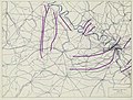 Situation Map 2 August 1944 Evreux - Paris - NARA - 100384793.jpg 8,704 × 6,633; 4.38 MB
-

-
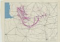
 Situation Map No. 2 November 1944 Düren - Eschweiler - Stolberg - NARA - 100385139.jpg 6,608 × 8,750; 5.37 MB
-

-
-
 Special Map - NARA - 100385279.jpg 5,400 × 6,494; 3.07 MB
-
 Special Road Study - Saarbrüken - NARA - 100384470 (page 1).jpg 6,600 × 8,774; 6.84 MB
-
 Special Road Study - Saarbrüken - NARA - 100384470 (page 2).jpg 6,600 × 8,769; 2.95 MB
-
 Study of Dams of the Roer River and its Tributaries 10 June 1944 - NARA - 100385085.jpg 7,632 × 5,715; 2.54 MB
-
 Study of Dams of the Roer River and its Tributaries 10 September 1944 - NARA - 100385087.jpg 8,048 × 6,038; 2.45 MB
_(cropped).jpg)

.jpg)


_-_NARA_-_100384359_(page_1).jpg)
.jpg)
_(Operations_21-23_December_1944)_to_Accompany_Report_of_Operations_1-31_December_1944_-_DPLA_-_ddd1b9601880e0eae6d63ab8f26e8123.jpg)


_(cropped).jpg)


.jpg)

.jpg)
.jpg)

