Category:USGS ShakeMaps of earthquakes in the United States
Jump to navigation
Jump to search
Subcategories
This category has only the following subcategory.
Media in category "USGS ShakeMaps of earthquakes in the United States"
The following 38 files are in this category, out of 38 total.
-
 2010 Utah shakemap.jpg 612 × 667; 144 KB
-
 2010NewMexico.jpg 612 × 726; 108 KB
-
 2016 Oklahoma earthquake ShakeMap.jpg 612 × 718; 132 KB
-
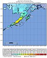
 2016 Old Iliamna earthquake shakemap.png 719 × 1,020; 756 KB
-
 2018-11-30 Anchorage, Alaska M7 earthquake shakemap (USGS).jpg 612 × 721; 141 KB
-
 2018-12-31 Cold Bay, Alaska M6 earthquake shakemap (USGS).jpg 894 × 1,093; 180 KB
-
 2019-04-02 Kiska Volcano, Alaska M6.4 earthquake shakemap (USGS).jpg 935 × 1,080; 159 KB
-
 2019-04-02 Kiska Volcano, Alaska M6.5 earthquake shakemap (USGS).jpg 995 × 1,078; 161 KB
-
 2019-05-23 Amatignak Island, Alaska M6 earthquake shakemap (USGS).jpg 891 × 1,081; 181 KB
-
 2019-05-23 Amatignak Island, Alaska M6.1 earthquake shakemap (USGS).jpg 892 × 1,083; 173 KB
-
 2020-01-23 Tanaga Volcano, Alaska M6.2 earthquake shakemap (USGS).jpg 815 × 1,027; 149 KB
-
 2020-03-31 Challis, Idaho M6.5 earthquake shakemap (USGS).jpg 779 × 1,005; 444 KB
-
-
 2020-05-15 Tonopah, Nevada M6.4 earthquake shakemap (nn).jpg 612 × 726; 156 KB
-
 2020-05-15 Tonopah, Nevada M6.4 earthquake shakemap (USGS).jpg 787 × 1,003; 389 KB
-
 2020-05-15 Tonopah, Nevada M6.5 earthquake shakemap (nn).jpg 612 × 726; 159 KB
-
 2020-05-15 Tonopah, Nevada M6.5 earthquake shakemap (USGS).jpg 787 × 1,003; 394 KB
-
 2020-07-22 Perryville, Alaska M7.8 earthquake shakemap (ak).jpg 612 × 658; 66 KB
-
 2020-07-22 Perryville, Alaska M7.8 earthquake shakemap (USGS).jpg 787 × 998; 201 KB
-
 2020-07-22 Sand Point, Alaska M6.1 earthquake shakemap (USGS).jpg 804 × 1,001; 162 KB
-
 2020-07-28 Sand Point, Alaska M6.1 earthquake shakemap (USGS).jpg 804 × 1,001; 212 KB
-
 2020-10-06 Sand Point, Alaska M6 earthquake shakemap (USGS).jpg 785 × 1,016; 196 KB
-
 2020-10-19 Alaska M7.5 earthquake shakemap (USGS).jpg 828 × 995; 199 KB
-
 2020-10-19 Sand Point, Alaska M7.5 earthquake shakemap (USGS).jpg 828 × 995; 200 KB
-
 2020-10-19 Sand Point, Alaska M7.6 earthquake shakemap (USGS).jpg 787 × 992; 206 KB
-
 2020-12-01 Nikolski, Alaska M6.3 earthquake shakemap (USGS).jpg 785 × 1,001; 160 KB
-
 2020-12-01 Nikolski, Alaska M6.4 earthquake shakemap (USGS).jpg 786 × 1,001; 160 KB
-
 2021-01-03 Adak, Alaska M6.1 earthquake shakemap (USGS).jpg 787 × 1,000; 143 KB
-
 2021-05-31 Chickaloon, Alaska M6.1 earthquake shakemap (ak).jpg 787 × 979; 429 KB
-
 2021-05-31 Chickaloon, Alaska M6.1 earthquake shakemap (USGS).jpg 783 × 1,001; 379 KB
-
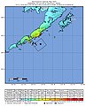
 2021-07-29 Perryville, Alaska M8.2 earthquake shakemap (ak).jpg 808 × 951; 257 KB
-
 2021-07-29 Perryville, Alaska M8.2 earthquake shakemap (USGS).jpg 787 × 968; 249 KB
-
 Anchorage earthquake shakemap.jpg 1,700 × 2,053; 2.67 MB
-
 M 7.8 - 105 km SSE of Perryville, Alaska - ShakeMap.jpg 803 × 991; 212 KB
-
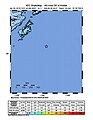 M 7.9 - 280km SE of Kodiak, Alaska - intensity.jpg 612 × 792; 63 KB
-
 USGS 2011 Oklahoma intensity.jpg 612 × 724; 146 KB
-
 USGS Shakemap - 1993 Scotts Mills earthquake.jpg 612 × 720; 191 KB
-
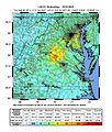 Virginia earthquake, Aug 23.jpg 612 × 720; 165 KB


.jpg)
.jpg)
.jpg)
.jpg)
.jpg)
.jpg)
.jpg)
.jpg)
.jpg)
.jpg)
.jpg)
.jpg)
.jpg)
.jpg)
.jpg)
.jpg)
.jpg)
.jpg)
.jpg)
.jpg)
.jpg)
.jpg)
.jpg)
.jpg)
.jpg)
.jpg)
.jpg)
.jpg)


