Category:Tuma Casti
Jump to navigation
Jump to search
| Object location | | View all coordinates using: OpenStreetMap |
|---|
tuma at Domat/Ems, Graubünden, Switzerland   | |||||
| Upload media | |||||
| Instance of | |||||
|---|---|---|---|---|---|
| Located in protected area |
| ||||
| Location | Domat/Ems, Grisons, Switzerland | ||||
| Height |
| ||||
| Area |
| ||||
| Elevation above sea level |
| ||||
 | |||||
Subcategories
This category has the following 2 subcategories, out of 2 total.
- Views from Tuma Casti (6 F)
C
Media in category "Tuma Casti"
The following 12 files are in this category, out of 12 total.
-
 Domat Sogn Pieder Kapelle.jpg 3,456 × 2,304; 3.3 MB
-
 Domat-Ems Com FC09-7013-019.jpg 3,431 × 2,400; 7.55 MB
-
 DomatEms StPeter1.JPG 2,352 × 1,568; 1.59 MB
-
 Ems (Domat), Switzerland (8391290701).jpg 1,024 × 663; 324 KB
-
 Graubuenden-02-Domat Ems-Kirchen-2006-gje.jpg 3,072 × 2,048; 2.78 MB
-
 Graubuenden-04-Domat Ems-Kirchen-2006-gje.jpg 3,072 × 2,048; 2.15 MB
-
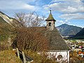 Kapelle St. Antonius (Domat-Ems).jpg 3,264 × 2,448; 4.78 MB
-
 Kraftwerk Reichenau.jpg 1,375 × 754; 483 KB
-
 Mittelhozer Domat-Ems.JPG 2,018 × 1,340; 1.68 MB
-
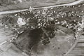
 Tuma Casti, Domat-Ems, 1991 (Com FC09-7013-019).jpg 543 × 325; 209 KB
-
 Tuma Landschaft.jpg 4,608 × 3,456; 4.9 MB
-
 Tumalandschaft Domat-Ems, Tuma Tschelli im Zentrum, 1991 (Com FC09-7013-019).jpg 2,456 × 1,082; 2.58 MB


,_Switzerland_(8391290701).jpg)


.jpg)


.jpg)

.jpg)