Category:Trees in South Ferriby
Jump to navigation
Jump to search
Media in category "Trees in South Ferriby"
The following 15 files are in this category, out of 15 total.
-

-
 Copse near North Wold Farm - geograph.org.uk - 1574249.jpg 640 × 431; 300 KB
-
 Entering South Ferriby - geograph.org.uk - 848883.jpg 640 × 480; 62 KB
-
 Humber Defence Pillbox - geograph.org.uk - 223112.jpg 640 × 480; 167 KB
-
 Lifting Bridge at Ferriby Sluice - geograph.org.uk - 495401.jpg 640 × 485; 115 KB
-
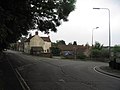
 Main road junction in South Ferriby - geograph.org.uk - 400692.jpg 640 × 431; 98 KB
-
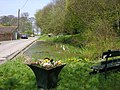
 Sluice Road (from east end) - geograph.org.uk - 400678.jpg 640 × 450; 105 KB
-
 South Ferriby Hall - geograph.org.uk - 225791.jpg 640 × 480; 128 KB
-
 South Ferriby Hall - geograph.org.uk - 231238.jpg 640 × 482; 158 KB
-
 South Ferriby War Memorial - geograph.org.uk - 1083140.jpg 640 × 427; 83 KB
-
 St.Nicholas' church - geograph.org.uk - 1083143.jpg 640 × 427; 58 KB
-
 The Hall, South Ferriby - geograph.org.uk - 537860.jpg 640 × 377; 109 KB
-
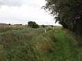 The Public Footpath to Winterton - geograph.org.uk - 293364.jpg 640 × 480; 118 KB
-
 Track Junction on the Viking Way - geograph.org.uk - 405103.jpg 640 × 385; 122 KB
-
 Village Pond - geograph.org.uk - 400709.jpg 640 × 480; 136 KB


_-_geograph.org.uk_-_400678.jpg)


