Category:Town hall in Kremnica
Jump to navigation
Jump to search
| Object location | | View all coordinates using: OpenStreetMap |
|---|
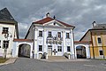
English: Townhall (Radnica) in Kremnica
Slovenčina: Radnica v Kremnici
| This category shows the protected monument with the number 613-2272/4 (other) in the Slovak Republic. |
Media in category "Town hall in Kremnica"
The following 10 files are in this category, out of 10 total.
-
 Kremnica - Radnica - pam. tabuľa.jpg 4,608 × 3,072; 3.92 MB
-
 Kremnica - Radnica.jpg 4,608 × 3,072; 3.79 MB
-
 Kremnica - Rímsko-katolícka fara (1).jpg 4,608 × 3,072; 3.55 MB
-
 Kremnica - Štefánikovo námestie (3).jpg 4,287 × 2,862; 3.33 MB
-
 Kremnica, radnica.jpg 3,968 × 2,976; 2.42 MB
-
 Kremnica4.jpg 3,456 × 5,184; 7.61 MB
-
 Körmöcbánya09.JPG 1,728 × 2,304; 604 KB
-
 Radnica v kremnici.jpg 720 × 960; 67 KB
-
 RadnicaKremnica.JPG 2,560 × 1,920; 1.75 MB
-
 SK-Kremnica-Rathaus.jpg 3,084 × 2,560; 1.98 MB


.jpg)
.jpg)


