Category:Touring Club Italiano maps showing history
Jump to navigation
Jump to search
Media in category "Touring Club Italiano maps showing history"
The following 40 files are in this category, out of 40 total.
-
 Esportazioni tessili a Bologna 1670-1800.jpg 684 × 474; 79 KB
-
 Map Ancient Egypt 1928-1940 - Touring Club Italiano CART-TRC-34.jpg 4,551 × 6,298; 2.78 MB
-
 Map Ancient Palestine 1928-1940 - Touring Club Italiano CART-TRC-36.jpg 4,196 × 6,414; 2.61 MB
-
 Map Austria and the spartitions of Poland 1928-1940 - Touring Club Italiano CART-TRC-60.jpg 6,290 × 6,846; 4.53 MB
-
 Map Austria in the napoleonic age 1928-1940 - Touring Club Italiano CART-TRC-61.jpg 5,056 × 6,579; 3.63 MB
-
 Map Europe around 560 AD - Touring Club Italiano CART-TRC-50 01.jpg 3,873 × 3,205; 1.52 MB
-
 Map Europe in 1660- Touring Club Italiano CART-TRC-51 01.jpg 3,853 × 3,195; 1.58 MB
-
 Map Europe in 1789- Touring Club Italiano CART-TRC-51 02.jpg 3,836 × 3,065; 1.53 MB
-
 Map Europe in 1810- Touring Club Italiano CART-TRC-52 01.jpg 3,787 × 3,209; 1.56 MB
-
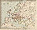 Map Europe in 1815- Touring Club Italiano CART-TRC-52 02.jpg 3,871 × 3,094; 1.56 MB
-
 Map Europe in 1878 1928-1940 - Touring Club Italiano CART-TRC-58 01.jpg 3,909 × 3,145; 1.6 MB
-
 Map Europe in 1914 1928-1940 - Touring Club Italiano CART-TRC-58 02.jpg 3,863 × 3,050; 1.58 MB
-
 Map Europe in 814- Touring Club Italiano CART-TRC-50 02.jpg 3,826 × 3,086; 1.51 MB
-

-
-

-
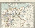
 Map Germany in 1520 1928-1940 - Touring Club Italiano CART-TRC-54 02.jpg 4,147 × 3,028; 1.63 MB
-
 Map Germany in 1815 1928-1940 - Touring Club Italiano CART-TRC-57 01.jpg 4,161 × 3,281; 1.68 MB
-
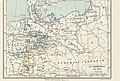 Map Germany in 1870 1928-1940 - Touring Club Italiano CART-TRC-57 02.jpg 4,507 × 3,040; 1.75 MB
-
 Map Italy around 1300- Touring Club Italiano CART-TRC-47.jpg 6,052 × 6,640; 4.72 MB
-
 Map Italy around 500 b.C. - Touring Club Italiano CART-TRC-40.jpg 6,046 × 6,651; 4.22 MB
-
 Map Italy at the time of Augustus- Touring Club Italiano CART-TRC-44.jpg 6,034 × 6,689; 4.97 MB
-
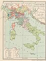
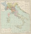 Map Italy in 1454- Touring Club Italiano CART-TRC-46.jpg 6,135 × 6,668; 4.74 MB
-
 Map Italy in 1559 - Touring Club Italiano CART-TRC-48 01.jpg 3,189 × 4,222; 3 MB
-
 Map Italy in 1748- Touring Club Italiano CART-TRC-48 02.jpg 3,010 × 4,139; 2.91 MB
-
 Map Italy in 1815- Touring Club Italiano CART-TRC-49 01.jpg 3,230 × 4,205; 1.65 MB
-
 Map Italy in the second half of 10th century- Touring Club Italiano CART-TRC-43 02.jpg 3,013 × 4,100; 1.46 MB
-
 Map Longobard-Byzantine Italy- Touring Club Italiano CART-TRC-43 01.jpg 2,999 × 4,224; 1.48 MB
-
 Map Map of the Persian Empire 1928-1940 - Touring Club Italiano CART-TRC-35.jpg 6,528 × 4,485; 3.45 MB
-

-

-
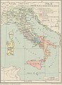
 Map of Italy in 1861 - Touring Club Italiano CART-TRC-49 02.jpg 3,030 × 4,159; 1.53 MB
-
 Map Rome in the Imperial Era- Touring Club Italiano CART-TRC-41.jpg 6,646 × 6,366; 3.82 MB
-
 Map The Acropolis of Athens and its slopes 1928-1940 - Touring Club Italiano CART-TRC-37.jpg 8,279 × 6,007; 31.78 MB
-
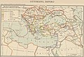
 Map The decadence of the Ottoman Empire- Touring Club Italiano CART-TRC-45 02.jpg 4,874 × 3,102; 1.82 MB
-

-

-

-
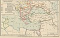
 Map The Ottoman Empire- Touring Club Italiano CART-TRC-45 01.jpg 4,877 × 3,317; 1.94 MB
-
 Map The Roman Empire under Trajan and Adrian- Touring Club Italiano CART-TRC-42.jpg 6,816 × 5,069; 4.02 MB


